|
|
|
|
|
This page last updated March 8, 2024 |
Below are historical plans for the San Antonio area freeway system. The general citywide plans are followed by proposals for specific interchanges or routes that were eventually not implemented. The images were sourced from the TxDOT photo library, the San Antonio TxDOT district office, and San Antonio-Bexar County Urban Transportation Study (SABCUTS) planning documents.
Click on each photo for an enlarged view.
Click here to return to the historical photo galleries page.
|
ADVERTISEMENT |
|
1955 proposed locations for Interstate Highways Map of proposed locations for Interstates in San Antonio from the Bureau of Public Road's "General Location of National System of Interstate Highways" publication, also known as the "Yellow Book" because of its yellow cover. Published in 1955, it was essentially the blueprint for the Interstate Highway System. Notice the proposed routing for I‑10 East through the East Side and downtown — I believe this represents a proposal at the time that would have routed that expressway through King William, Southtown, and the Indiana St. and Aransas Ave. corridors. Also, note the proposed route for I‑10 West was along Fredericksburg Rd. — this one looks like it may have been a "placeholder" alignment since I have not found any other proposal for this route. Lastly, note the omission of the northern stretch of Loop 410 — due to a design disagreement between the state and federal highway officials, it would not be added to the Interstate system until 1969. (Wikipedia.org) |
|
1955 proposed locations for Interstate Highways Map of proposed locations for Interstates in San Antonio from the Bureau of Public Road's "General Location of National System of Interstate Highways" publication, also known as the "Yellow Book" because of its yellow cover. Published in 1955, it was essentially the blueprint for the Interstate Highway System. Notice the proposed routing for I‑10 East — roughly the Nueva St. corridor downtown and Commerce St. through the East Side. Also, the proposed route for I‑10 West was along Fredericksburg Rd. In both of these cases, these were probably "placeholder" alignments while the routings for each were finalized. Lastly, note the omission of the northern stretch of Loop 410; due to a design disagreement between the state and federal highway officials, it would not be added to the Interstate system until 1969. (Wikipedia.org) |
|
|
|
|
|
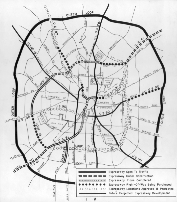
1956 expressway plan This was the first plan for a comprehensive citywide freeway system and the first proposal for what would become Loop 1604. Also note the proposals for expressways along Bandera Rd., Roosevelt Ave., and Zarzamora St. (TxDOT) |
|
1956 expressway plan This was the first plan for a comprehensive citywide freeway system and the first proposal for what would become Loop 1604. Also note the proposals for expressways along Bandera Rd., Roosevelt Ave., and Zarzamora St. (TxDOT) |
|
|
|
|
|
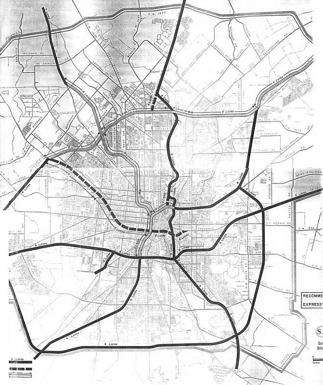
1964 expressway plan Note the connectors from US 281 to Loop 410 along San Pedro and from US 281 to I‑35 along St. Mary's as well as the updated Bandera Freeway proposal. (SABCUTS) |
|
1964 expressway plan Note the connectors from US 281 to Loop 410 along San Pedro and from US 281 to I‑35 along St. Mary's as well as the updated Bandera Freeway proposal. (SABCUTS) |
|
|
|
|
|
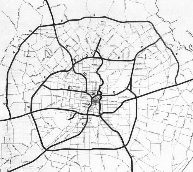
1975 expressway plan This shows the final iteration of the Bandera Freeway along Culebra before it was cancelled. (SABCUTS) |
|
1975 expressway plan This shows the final iteration of the Bandera Freeway along Culebra before it was cancelled. (SABCUTS) |
|
|
|
|
|
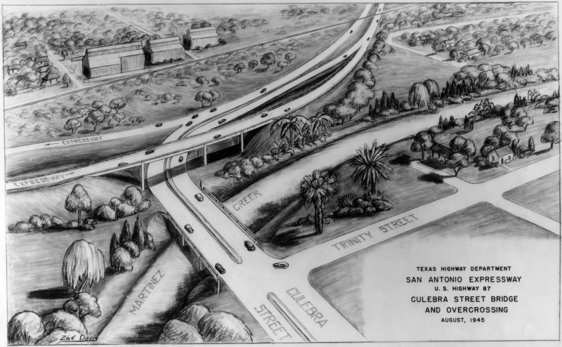
Proposed I‑10 (US 87) and Culebra interchange (1945) (TxDOT) |
|
Proposed I‑10 (US 87) and Culebra interchange (1945) (TxDOT) |
|
|
|
|
|
Proposed routing for I‑10 (US 87) from Hildebrand Ave. to Fredericksburg Rd. (1953) This was the first proposal to route I‑10 West. It would have run significantly further east than the eventual alignment. (Due to the size of this image, it will open in a separate window that you can scroll and zoom.) (TxDOT) |
|
|
|
|
|
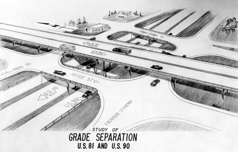
Proposed interchange for US 90 and I‑35 (1953) This was the first proposal for the US 90 expressway. It would have run substantially further north than the eventual alignment, generally following Guadalupe St. through the West Side and crossing I‑35 (US 81) at El Paso St. Notice that this would have only been a three-level interchange requiring traffic to exit and use the access roads to go from one freeway to the other. (TxDOT) |
|
|
|
|
|
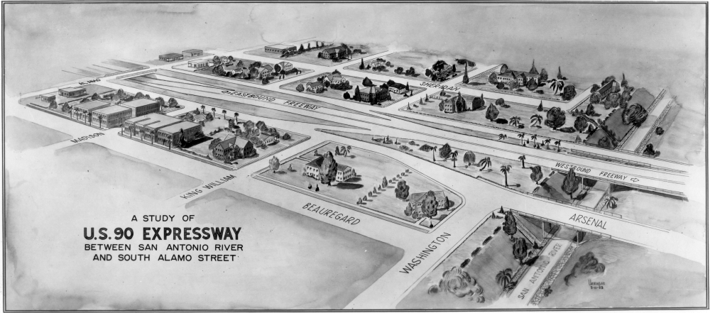
Proposed routing for US 90 through King William (1953) Continuing east from the interchange at I‑35, the proposed US 90 expressway would have sliced through King William and Southtown between Beauregard St. and Sheridan St. Heading east, it would have crossed I‑37 at Indiana St. and followed the Indiana St. and Aransas Ave. corridors through the East Side. (TxDOT) |
|
|
|
|
|
Proposed Fratt Interchange (I‑35/Loop 410 North) (ca. 1954) This was the first proposal for the Fratt Interchange. This plan also shows that the initial proposed route for I‑35 north of the interchange was along Randolph Blvd. (Due to the size of this image, it will open in a separate window that you can scroll and zoom.) (TxDOT) |
|
|
|
|
|
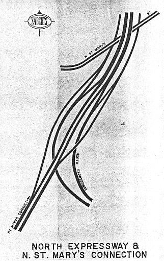
Proposed US 281/St. Mary's Connection interchange (1964) The St. Mary's Connector was a proposed short freeway connecting from US 281 into downtown. (SABCUTS) |
|
Proposed US 281/St. Mary's Connection interchange (1964) The St. Mary's Connector was a proposed short freeway connecting from US 281 into downtown. (SABCUTS) |
|
|
|
|
|
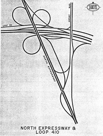
Proposed US 281/Loop 410 interchange (1964) This interchange was never built due to escalating costs after the freeway was delayed by lawsuits for a decade. (SABCUTS) |
|
Proposed US 281/Loop 410 interchange (1964) This interchange was never built due to escalating costs after the freeway was delayed by lawsuits for a decade. (SABCUTS) |
|
|
|
|
|
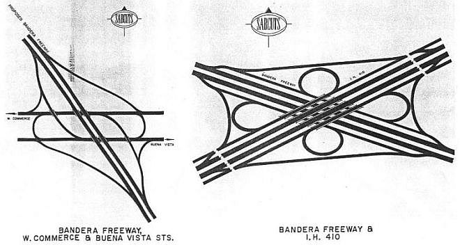
Proposed Bandera Freeway interchanges (1964) (SABCUTS) |
|
Proposed Bandera Freeway interchanges (1964) (SABCUTS) |
|
|
|
|
|
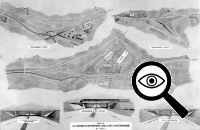
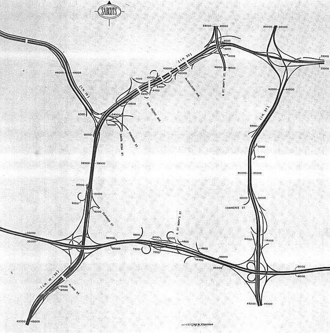
Proposed downtown distribution system (1964) This was a plan for an intricate system of entrance and exit ramps along the downtown freeways. Most of the ramps were never built as proposed. The numbers on the map were projected traffic volumes. Note the location of the freeway across the southern end of downtown; this was the proposed location of the Bandera Expressway (see the 1964 expressway plan above) and was very similar to the earlier proposed routing for US 90. (SABCUTS) |
|
|
|
|