|
||
|
|
||
This page last updated January 30, 2024 |

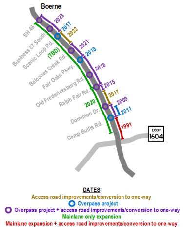
Since the late aughts, TxDOT has been working on a series of projects on I‑10 West between Loop 1604 and SH 46 to improve intersections, add new overpasses and widen existing ones, convert the access roads to one-way operation, and expand the mainlanes. This page contains information about the projects from Ralph Fair Rd. to SH 46 in Boerne.
Note that all this work on I‑10 between Loop 1604 and Boerne has been a series of individual projects, not one continuous project (see Q&A below for why.)
The overarching goal of several of these projects has been to convert the access roads to one-way operation from Leon Springs to Boerne. As this area continues to become more developed, one-way access roads will be safer and more efficient. For optimal operation and convenience, there needs to be a crossover every mile or so. Otherwise, someone turning onto a one-way access road just past an intersection and wanting to go the opposite direction could have to travel several miles out of their way; having a crossover every mile or so both minimizes this inconvenience and provides better access for emergency vehicles. This is the reason why new overpasses at Old Fredericksburg Road and Balcones Creek Road were included in the plans, and also was the primary reason that the overpass at Dominion Drive was built a decade and a half ago (despite cynical misinformation alleging otherwise).
None of these projects are related to the recent Kendall Gateway study.
The schematics included for each project below are courtesy of TxDOT; the annotations on them are my own.
Here's an analogy: Imagine you want to renovate your house, but you don't have the money to do it all at once. So you make a plan based on your income and figure you can do one project every two years, which means there will be breaks between projects, but it will take eight years or so to get them all done. You start work on the kitchen, but while that's underway, you get an unexpected bonus at work. So you use it to do one of the bathrooms, which is a couple of years earlier than planned. Then a year later, you come into some more money and so now you can do another bathroom three years earlier than you expected, and you can also replace the floors five years earlier than you planned. So now, you have a house that's constantly under construction, but it's getting done faster than you planned. This is essentially what happened on this stretch of I‑10.
The map below shows the timeline of all the projects in this corridor.
|
ADVERTISEMENT |
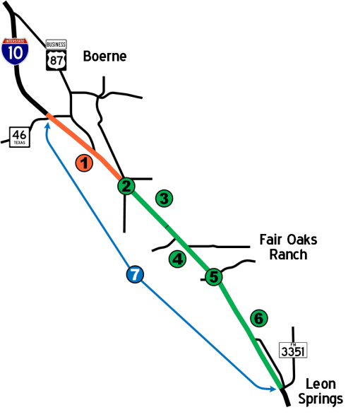
| 1 | SH 46 to Scenic Loop Rd. |
This project overhauled and redesigned the interchanges at SH 46 (W Bandera Road) and at Business 87 (S Main Street), completed the westbound frontage road between Business 87 and Christus Parkway, converted all the frontage roads to one-way, and changed the locations of the entrance and exit ramps.
At SH 46, the existing overpass was replaced with a new overpass consisting of two through lanes and a left turn lane in each direction. The access roads adjacent to the overpass were re-aligned inward toward the mainlanes, and portions of the old access roads at School St. and Upper Balcones Rd. were converted to local service streets to maintain access but re-configured to minimize conflicts. A westbound to eastbound turnaround was also constructed. Although not shown on the schematic below, the park & ride lot was kept but was reconfigured.
The Business 87 interchange was rebuilt as a more conventional intersection. A new, wider overpass replaced the previous overpass and now ends in a "T" intersection at a realigned eastbound access road. (The City of Boerne plans to eventually build a new thoroughfare to serve Buc-ees there.) There are now turnarounds for both directions. A new westbound access road now continues beyond the new intersection and joins with the frontage road near Christus Parkway. The existing entrance and exit ramps were relocated further south from the intersection.
At Scenic Loop, an eastbound to westbound turnaround was built, and the entrance and exit ramps north of Scenic Loop were relocated further north.

|
There was an ongoing rumor on social media "from a credible source" that the first half of the new SH 46 overpass was defective and would have to be torn-down and rebuilt. This was obviously not true as traffic was shifted onto that "defective" new overpass without it being torn-down and rebuilt, and the second half of the new overpass has now also been completed. The moral of the story: don't believe the rumors you read on social media — they're usually wrong. |
- Work started in June 2018
- Estimated completion: Substantially complete!
- Q: Why did this project take so long?
A: I don't work for TxDOT, and I don't have any inside details on this one, so this is strictly my own impression based on what I do know about this project and my experience observing highway projects for decades: The contractor working this project is one I had never heard of before, and they might have bitten off more than they can chew as they didn't seem to be as capable as most of the regular contractors that I've seen work big TxDOT jobs. There certainly were a few issues outside of their control, but frankly it seems like they committed more unforced errors on this job than I've seen in a long time. They paid a penalty in excess $1.1 million for missing the completion deadline. The good news is that this project is finally substantially complete with just final "punch list" items to finish up.
| 2 | At Scenic Loop Rd. |
This project lengthened and increased the height of the I‑10 overpass at Scenic Loop in preparation for future turnarounds and intersection expansion (projects 1 and 3 on this page).
- Completed in 2017
| 3 | Scenic Loop Rd. to Bexar county line |
This project converted the access roads between Scenic Loop Road and Balcones Creek Road to one-way, built a westbound to eastbound turnaround at Scenic Loop, relocated the entrance and exit ramps further south, constructed new entrance and exit ramps for Balcones Creek Road (see project #4 below), and constructed new higher access road bridges over Balcones Creek. The existing "lower" access roads and crossover under I‑10 at Balcones Creek were kept.
- Completed in early 2022
| 4 | Kendall county line to Fair Oaks Pkwy. |
This project constructed a new overpass for I‑10 at Balcones Creek Road and the access roads are were converted to one-way from Balcones Creek Road to Fair Oaks Parkway. An eastbound to westbound turnaround at Fair Oaks Parkway was also built as part of this project. The access roads between Balcones Creek Road and Scenic Loop Road were converted to one-way in a separate project (see #2 above).
- Completed in early 2021
| 5 | At Fair Oaks Pkwy./ |
This project widened the overpass to five lanes and realigned it to join Fair Oaks Parkway directly to Tarpon Drive. The access roads south of Fair Oaks Pkwy were converted to one-way, and the entrance and exit ramps were relocated as part of project #6 below. The current project at Balcones Creek Road (above) converted the access roads north of Fair Oaks Pkwy. to one-way and relocated the entrance and exit ramps north of Fair Oaks Pkwy.
- Completed in 2018
| 6 | Fair Oaks Pkwy./ |
This project built a new overpass at Old Fredericksburg Road connecting it to Buckskin Drive. The access roads were converted to one-way, new entrance and exit ramps for this intersection added, and the exit and entrance ramps for Ralph Fair Road/Boerne Stage Road were relocated.
- Completed in 2018
- Q: Why are the signals at the new Buckskin/Old Fredericksburg intersection still flashing red?
A: At the time this project was planned, Bexar County was planning to close Old Fredericksburg Rd. at Ralph Fair Rd., and planners anticipated doing so would redirect a substantial amount of traffic to this intersection. So the signals were included in the overpass project so they would be ready for use when needed rather than have to come back later and install them. The plans for Old Fredericksburg Rd. have since changed, so for now, traffic volumes at this intersection only necessitate a four-way stop, and the signals are used to supplement that. Engineers are monitoring traffic at this intersection and will switch to full red-yellow-green signal operation if ever traffic volumes warrant.
| 7 | SH 46 to Ralph Fair Rd. |
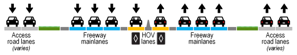
This roughly $250 million project will expand the I‑10 mainlanes to add one general-purpose mainlane in each direction (for a total of three) plus one HOV lane in each direction. All of the projects above were designed with this project in mind.
- This project is currently "penciled-in" to start in 2031, but it is currently unfunded and therefore that date is simply a placeholder.
- This project may be divided into smaller projects/phases to take advantage of available funding.
- Q: Why wasn't this done in conjunction with all of the other projects in this corridor?
A: This is due to funding limitations. Around the turn of the century, TxDOT developed a master plan for improvements to I‑10 from Loop 1604 to Boerne. However, because of funding constraints at that time, that plan had to be broken into multiple smaller projects in order to fit within projected funding levels, with each project being an incremental step toward the larger vision. Although funding levels have improved over the past decade (thus resulting in the flurry of projects seen to date), this final project to compete that master plan has a large enough price tag that it is still in line for funding.
Other sites of interest
|
|
TxDOT - I‑10 Kendall Extension https://www.txdot.gov/ |
|
|
TxDOT - I‑10 and Scenic Loop Road https://www.txdot.gov/ |
|
|
TxDOT - I‑10 from SH 46 to FM 3351 (Ralph Fair Road) https://www.txdot.gov/ |
|
|
TxDOT - I‑10 W Perimeter https://www.txdot.gov/ |