|
|
|
|
|
This page last updated August 9, 2025 |
A "Restricted Crossing U‑turn" intersection (RCUT) — also known as a "superstreet" or "J-turn" — is a divided roadway where the major intersections have been modified to eliminate left turns and straight-through traffic on the road that intersects the main roadway, and where minor intersections are converted to "right-in/right-out", i.e. traffic can only turn right onto or from those streets. Turnarounds are then provided to facilitate left turns and crossovers via a U‑turn instead.
This configuration improves traffic flow and safety. At the signalized intersections, doing this reduces the number of traffic signal phases required to move traffic through the intersections from typically five or more to just two, thereby allowing for longer green times for all movements without extending the overall cycle time, thus reducing wait times and the resulting congestion.
This is one of several "innovative" or "alternative" intersection types used to improve intersection throughput when grade-separation (overpasses or flyovers) is not possible, not warranted, or too expensive.
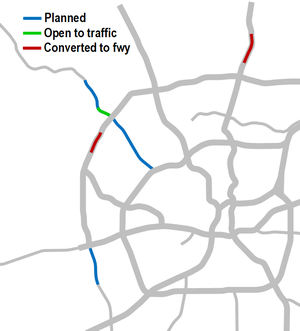
The San Antonio area has had four sections of RCUTs: one on US 281 North (four intersections, replaced when US 281 was upgraded to a freeway), one on Loop 1604 West (two intersections, also replaced with a freeway), one on Bandera Rd. (three intersections), and Loop 337 in New Braunfels (three intersections).
In the 281 and 1604 cases, the RCUTs were in a transition area between freeway and non-freeway sections of those roads, and both were intended to be short-term improvements while the upgrade of those segments to freeways was stalled due to various legal challenges and funding issues. The 281 and 1604 RCUTs were the first two superstreets in Texas.
An RCUT intersection was completed on Bandera Rd. at FM 1560 South in 2018. Two more intersections — at Hausman Rd./Leslie Rd. and at Cedar Trail — were completed in 2024. These were the first two phases of RCUT intersections planned from Loop 1604 to Triana Parkway. Unlike those on US 281 and on Loop 1604, the RCUT plan on Bandera is considered to be a long-term solution for existing and expected congestion. RCUTs are now also planned for Bandera Rd. between Loop 1604 and Loop 410.
Finally, another RCUT section is planned on Loop 1604 between US 90 and Macdona Lacoste Rd., where it is also intended to be a long-term solution.
|
ADVERTISEMENT |
On this page:
Local RCUT history
The MPO approved funding for the project on March 23rd, 2009. Funding came from a combination of funds from the federal stimulus, Advanced Transportation District, and City of San Antonio. On January 14th, 2010, ARMA's board selected Ballenger Construction's bid of $5.2 million to build the project, which was nearly 20% below the final estimates and nearly 50% below initial projections. Ground was broken on the project on March 11th, 2010.
The first intersection (Encino Rio) was completed on August 29th, 2010. Weather delayed work on the Marshall Rd. intersection; it was finally completed on September 26th. The remaining intersections were completed on the weekends of October 2nd and 9th. As planned, the RCUT intersections were subsequently removed when the corridor was upgraded to a freeway in 2021.
In May 2010, ARMA previewed the initial designs and expected benefits. Under the plan, the intersections of New Guilbeau Rd. and Shaenfield Rd. would be reconstructed as RCUT intersections. It was estimated that by doing so, travel speeds could be increased by 36% and delays reduced by 69% during the morning peak, and that average travel speeds could be increased by 65% and delays reduced by 79% during the evening peak period.
The project began construction in March 2011. The New Guilbeau intersection was completed August 18th, followed on September 15th by the Shaenfield intersection. As intended, the RCUT intersections were subsequently removed when the corridor was upgraded to a freeway in 2016.
In 2022, earlier plans for an expansion of Loop 1604 West from US 90 to Macdona Lacoste Rd. to a divided highway were updated to include a full RCUT configuration. Construction is expected to start in 2026.The next section — from Loop 1604 to FM 1560 — was completed in late 2024. The remaining intersections from FM 1560 to Triana Pkwy. are currently unfunded and therefore there is currently no timeline for their completion.
The second proposed segment for Bandera Rd. was between Loop 410 and Loop 1604, but was shelved after Leon Valley declined to endorse it. However, an RCUT corridor is now the recommended alternative after other proposals were studied. Leon Valley has endorsed it this time around. There is currently no funding or timeline for its implementation.

|
Please note that the intersection diagrams below are generalized for the types of intersections involved and not intended to reflect specific existing or future conditions. They are intended instead to illustrate the concepts being discussed. Thanks to "SPUI" for the base RCUT intersection illustration used in the intersection diagrams. |
Conventional intersection operation
Before explaining how an RCUT works, it's important to understand how conventional intersections function, especially with regards to the traffic signal operation. Understanding the signal phasing is vital to grasping the improvements provided by an RCUT.
 What is a signal phase? A signal phase is the green time assigned to a specified movement or collection of simultaneous movements in a traffic signal cycle. In other words, when the signal is green for a specific movement (straight through, left turn, etc.), that's a signal phase. When it changes to red and another movement gets a green signal, that's another phase. The complete rotation through of all of the phases is a cycle. |
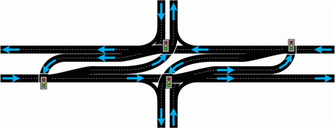
This is how a typical conventional intersection is configured; the road going left-to-right is the main road:
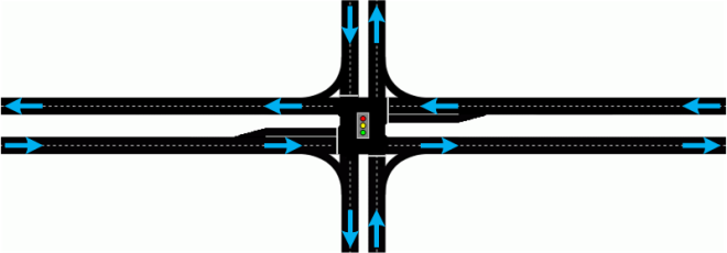
The "split-phase" signal configuration often used at these intersections requires five signal phases (i.e. signal changes) per cycle (or three phases for "T" intersections) to allow for each movement through the intersection:
Phase 1
Phase 2
Phase 3
Phase 4
Phase 5
So, if you get stopped just as the light is turning red, you have to wait for three or four other directions to have a green light before you get to go. Some signal plans can even have as many as eight phases per cycle!
In a congested intersection, the number of phases and the required length of each phase due to heavy traffic volumes causes overall signal cycles to be long, thus causing long queues and congestion, especially during peak periods. Additionally, each signal phase adds up to 10 or so seconds of "lost" time due to yellow and all-way red clearance intervals, as well as the time it takes for stopped motorists to react to a green and to start moving.
Many times, people will say that the signal timings simply need to be adjusted in order to reduce the congestion. In some cases, signal timings can be further optimized to improve conditions. However, in most cases, signals are already optimized as much as they can be, and the laws of physics prevent wringing-out any further efficiency in the existing intersection. When this happens, the intersection must be physically changed.
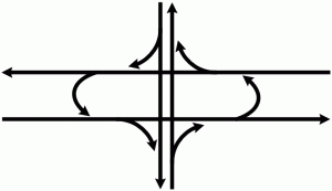
How an RCUT intersection works
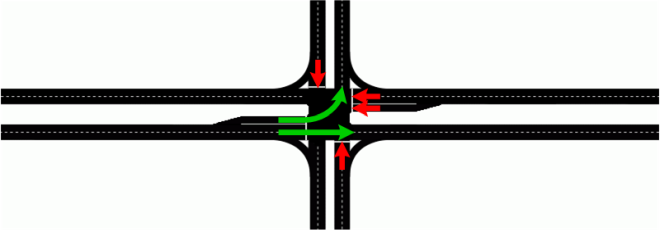
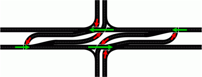
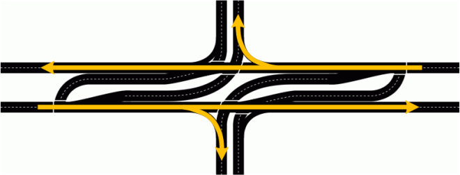
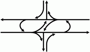
An RCUT reconfigures intersections like this:
At first glance, this looks quite complicated, perhaps overly so. But it actually makes sense once you understand how it works and why.
As you can see on the schematic, an RCUT intersection eliminates the ability of traffic on the cross street to continue straight through the intersection or to turn left (that's the "restricted crossing" part of the name). Instead, all traffic on the cross street must turn right onto the main road, then use a downstream turnaround (the "U‑turn" part of the name) to either go the opposite direction or to return to the cross street to continue on it. Those turnarounds are typically located approximately 1000 feet (about 2⁄10th of a mile) from the intersection they serve to allow sufficient room for merging and storage.
So how does this help? By eliminating the through-traffic and left-turns from the cross streets, the signal phases required for those movements can also be eliminated (or, more specifically, they're combined with the phase for traffic turning left from the main road onto the cross street). It is by eliminating those signal phases that the benefit is derived (keep reading.)
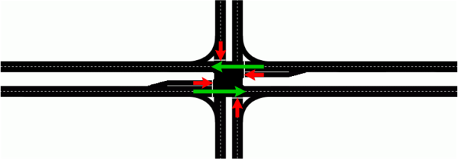
While RCUTs in areas with low traffic volumes can operate fine with stop or yield signs, most RCUTs (including all those in San Antonio to date) are signalized, and, in fact, it actually doubles the number of signals in each direction. Yes, it seems counter-intuitive that adding signals can help improve traffic flow. But it's not the number of signals that causes problems; it's the time required to service each movement at the intersection that causes backups. By eliminating the straight-through and left turn movements on the cross street, the number of signal phases (green time for a movement) is reduced from the previous five phases to just two (or from three to two at "T" intersections):
Phase 1
Phase 2
That's it — just two signal phases! Notice how many movements are accomplished in the second phase. This essentially takes phases 4 and 5 and the left turn movements of phases 1 and 3 of the conventional intersection discussed above and combines them all into one, eliminating all the time required for those individual phases.

|
If all of that sounds like technical gibberish, here's another way of explaining it: At a traditional intersection, drivers who arrive as the light turns red have to wait for three or four other directions to get a green light before their light turns green again. At an RCUT intersection, drivers only have to wait for one signal change before they get a green again. Drivers then needing to use the turnaround may have to subsequently wait for one more signal change, but that's still less than before. |
Furthermore, significant additional time savings is realized because every signal phase inherently includes some "wasted" time in the form of the yellow and all-way red clearance intervals, as well as the time it takes for drivers to start moving when they get a green light. All of that can add 5-10 seconds of lost time per phase.
All of these time savings allow the green time for through traffic on the main road to be increased without having to correspondingly reduce the green time for the cross street or lengthen the total cycle time.
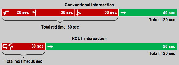
Imagine in the diagrams above that you're on the main road headed from left to right. You reach the conventional intersection just as the light turns red (phase 3). You then have to wait through phase 3 for 20 seconds, phase 4 for 30 seconds, and phase 5 also for 30 seconds before you get a green light again on phase 1, for a total wait time of 80 seconds.
With the RCUT, all of the movements that took 80 seconds before can now move at once and therefore be accomplished in a single 30 second phase, which means that through traffic on the main road is now only stopped for 30 seconds per cycle instead of 80 seconds. The 50 seconds of time that's been freed-up by eliminating two phases can now be added to the green time for the main road. So if through traffic previously was allocated 40 seconds of green time, it can get 90 seconds with the RCUT without any change to the overall two minute cycle time. This an obvious and substantial improvement and is where the benefit of a RCUT is derived. (See the box below for a graphic visualization of these timings.)
In practice, the cycle time is typically able to be reduced so that there are about two cycles at an RCUT intersection for every one cycle at a conventional intersection; this essentially moves twice as much traffic through an RCUT intersection in the same amount of time as compared to a conventional intersection. (Note that the timings I provide here are for illustrative purposes only and do not necessarily reflect any specific actual current or previous phase and cycle times.)
|
Example signal timings Below are simplified timelines showing example signal phase timings for each movement at an intersection from the perspective of through traffic on the main road moving left to right in the diagrams above. Note that these timings are simplified for illustrative purposes only; they do not represent actual timings, and the actual phasing is a bit more complex and can vary throughout the day. In practice, the cycle time for an RCUT is typically able to be significantly shortened, resulting in about two cycles for an RCUT for every one cycle for a conventional intersection. Be sure to read the explanation above. |
|
Note that the 30 seconds for the cross street in the RCUT could then be increased to further reduce congestion on those approaches if necessary and still leave significantly more green time for the main road than it would have in a conventional intersection. For example, the cross street could be allocated 40 seconds of green time, leaving 80 seconds for the main road, which is still twice as much as it had before. This demonstrates the additional flexibility afforded by this design.
If that's still not making sense, below is yet another way of looking at it.
Example Bandera Rd. - Hausman Rd./Leslie Rd. signal timings
|
|
|
Previous (conventional)
|
RCUT*
|
|
Blue sections represent Bandera Rd. traffic * The orange slice in the RCUT used the largest orange slice from the conventional intersection and can be increased if needed. Read the fourth point in the explanation above for more details. |
|
But with an RCUT, all the movements on one side of the intersection don't affect the other side at all, so the signals for traffic going in one direction on the main roadway are completely independent of those for the other direction. In effect, each side of the main road functions like an independent one-way street. This provides the ability to coordinate the signals much more easily and reliably without regards to the number of signals or their spacing, and the signals can react better to the traffic conditions on their side of the road. Essentially, it provides the optimal environment for signal coordination.
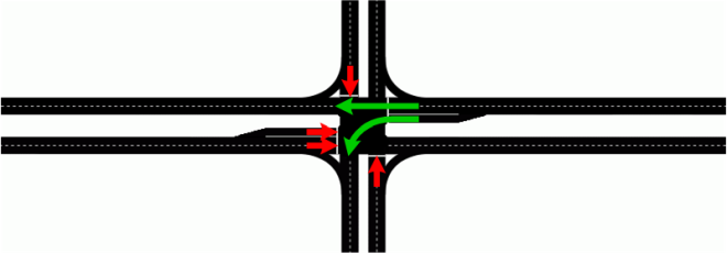
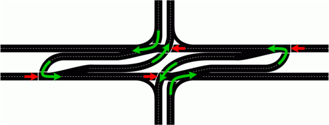
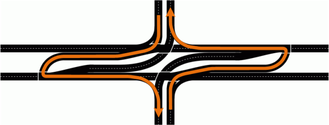
Straight-through traffic on the main road and traffic turning right onto the cross street works just like a conventional intersection:
Traffic turning left from the main road to the cross street also works just like a conventional intersection:
And traffic turning right onto the main road from the cross street works just like a conventional intersection:
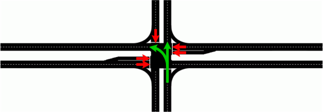
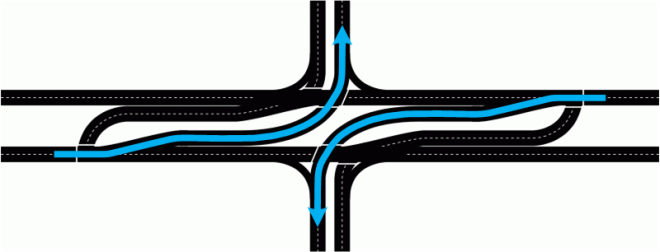
However, traffic wanting to turn left from the cross street onto the main road instead turns right, then uses the downstream turnaround to head the other direction:
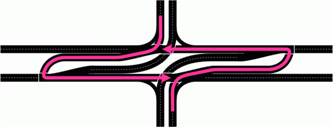
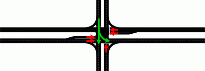
Similarly, traffic wanting to continue straight on the cross street across the main road instead has to turn right, use the downstream turnaround, then turn right again to get back onto the cross street:
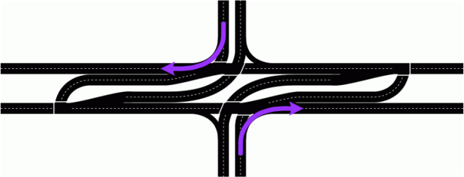
Finally, at an RCUT intersection, U-turns are generally prohibited from the left turn lanes. Therefore, traffic wanting to make a U-turn must go to the dedicated turnaround:

Also, restricting when vehicles can cross helps to create a "platoon" of vehicles when the light turns green. When signals are coordinated, they are timed to more efficiently move platoons of vehicles, so vehicles crossing over individually while the light is red often won't get that benefit (i.e. still have to wait for the signal at the turnaround anyway). Yes, this does inconvenience drivers who just want to turn right and not make the U‑turn, so where possible, the far right lane is allowed to make a right turn on red since drivers in that lane are very unlikely to be headed to the turnaround. This was done at a couple of intersections on US 281 and will be done at two intersections in the Helotes RCUT project. Right on red was also allowed for the Bandera/Circle A Trail intersections in Helotes due to the low traffic volumes there.
|
ADVERTISEMENT |
FAQ
- This is too confusing and will causes lots of accidents.
This is always one of the first visceral assertions made when an unconventional intersection is introduced. With any change — even more conventional changes such as new signals or lanes — it naturally takes drivers a little time to adapt. With an RCUT, because all traffic on the intersecting street is forced to turn right, most confusion is quickly overcome instinctively once the driver has turned or as they follow other more experienced drivers through the intersection. Additionally, because all traffic is flowing in the same direction and is protected by signals, the likelihood of collisions is substantially reduced, even during the adjustment period. RCUTs inherently improve safety by reducing conflict points (the point where vehicle paths cross) by half. And statistics for RCUTs show improved safety. A study for the North Carolina DOT showed that RCUTs reduced traffic collisions by 46% and decreased crashes with injuries by 63%. A study of RCUT intersections in Missouri showed a 54% reduction in injury and fatal crashes. Many people predicted mayhem at the Bandera/1604 displaced left-turn intersection, but crashes decreased 40% in the first nine months the DLT was in operation, and the number of crashes in 2021 was less than half of those in 2016 and 2017 before construction began, despite equivalent traffic volumes. - How does adding even more traffic signals help?/How does this crazy design improve traffic?
This intersection design improves traffic because, by forcing all traffic on the cross street to turn right, the green time for that can be overlapped with the green time for traffic turning left from the main road onto the cross street. This essentially eliminates the green time that would be needed for the through and left turn movements on the cross street, so that time can then be reallocated to the remaining movements, thus moving more traffic through the intersection in the same amount of time. Although there are extra signals, they are all much more efficient because they only have to change twice per cycle instead of the four or five changes required at a traditional intersection. Because of this simplicity, they can also be much more easily synchronized. - It won't be easy or safe to cross over to the turnarounds or turn from the turnaround.
A question often posed by people unfamiliar with RCUTs is how traffic from the cross streets can safely merge onto the main road, then move across the traffic lanes to the turnaround, then merge back into the other direction. The answer is that there are signals that stop the through traffic on the main road to allow that cross street traffic out at both the main intersection and also again at the turnarounds. As discussed above, even though the signals at the main intersections remain and extra signals are added at the turnarounds, the number of signal phases for all the signals is reduced substantially, thus allowing significantly more green time for the main road through traffic and signal synchronization is much easier. - This causes people to have to go out of their way, which is inconvenient and will require more time to get across.
Some folks understandably are peeved that to turn left or go straight from the cross street requires going out of one's way to accomplish. This is true and will always be perceived as an inconvenience by some drivers. While it is true that RCUTs can cause a slight increase in travel time for some movements during off-peak periods, the payoff comes periods of high traffic volumes where they have been shown to significantly decrease congestion and delays, reducing the time it takes to clear the intersection on all approaches, even when taking into account the additional distance required to use the turnaround. Also keep in mind that there are many other examples where traffic wanting to make a left turn is prohibited from doing so due to a median, freeway, or one-way street and must therefore turn right first, then make a downstream U‑turn or series of left turns, so this situation is not unprecedented or unique to RCUTs. - How do pedestrians cross an RCUT?
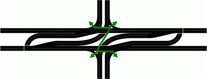
Below is a diagram of the typical pedestrian crosswalks and pathways in an RCUT intersection, all controlled by signals. Crossing the main road here is a bit safer than a conventional intersection because it is actually two much shorter crossings.
How an RCUT differs from a "Michigan Left"
People who have lived in Michigan and other parts of the country may be familiar with an intersection layout known as a "Michigan Left", also known as a "Median U‑turn or "MUT", and some have proffered that an RCUT is the same thing just with a different name. However, while a Michigan Left is similar to a RCUT, there are some significant differences between the two:
- In a Michigan Left, there are no left turns at all. All left turns from both the main road and cross street are made using the turnarounds. In an RCUT, traffic can make left turns from the main road onto the cross street, but left turns from the cross street are made using the turnarounds.
- In a Michigan Left, traffic on the cross street can go straight through. In an RCUT, all traffic on the cross street must turn right onto the main road. Straight-through traffic on the cross street must use the turnaround to return to the intersection, then make a right turn at the intersection to continue in their original direction.
Below are simplified schematics that show the allowed maneuvers in each type of intersection:
 |
 |
|
RCUT ("Superstreet") traffic flow
|
MUT ("Michigan Left") traffic flow
When both roadways have heavy traffic volumes, U‑turns can also be provided on the cross street.
|
|
RCUT ("Superstreet") traffic flow
|
| |
|
MUT ("Michigan Left") traffic flow
When both roadways have heavy traffic volumes, U‑turns can also be provided on the cross street.
|
Local RCUT results
| Metric | Before RCUT | After RCUT |
| Southbound travel time (Bulverde to Loop 1604, morning rush hour) |
23.3 minutes | 19.2 minutes |
| Southbound average speed (morning rush hour) |
16 mph | 19 mph |
| Northbound travel time (Loop 1604 to Bulverde, evening rush hour) |
19.2 minutes | 12.7 minutes |
| Northbound average speed (evening rush hour) |
19 mph | 29 mph |
| Traffic count (north of Evans) | 60,100 vehicles/day | 63,552 vehicles/day |
| Traffic count (south of Evans) | 74,000 vehicles/day | 81,526 vehicles/day |
Anecdotal reports for the first few weeks from motorists in the corridor on social media, from media reports (including this glowing review from an Express-News columnist, and even high praise from vociferous TxDOT antagonist and toll road crusader Terri Hall), and comments on various websites indicated that most of the time, the RCUTs provided some appreciable relief. Recurring traffic signal malfunctions for the first month or so after completion of the project did cause some initial problems; those were later attributed to the fact that the signal controllers used for the project were a new model, and the issues were resolved with assistance from the traffic signal equipment vendor.
Furthermore, because of their ability to better handle traffic, the RCUTs were kept during the construction to upgrade US 281 to a freeway.
Anecdotally, the Loop 1604 superstreet had a more profound reduction in congestion than the one on US 281 due to the lower traffic volumes on Loop 1604. The most glaring example of the improvement was on weekends. Before the superstreet, the entire segment from Braun to Shaenfield was typically congested in both directions most of Saturday and Sunday afternoon; after the superstreet, there was virtually no weekend congestion on that segment.
Other sites of interest