|
|
|
|
|
This page last updated December 7, 2024 |
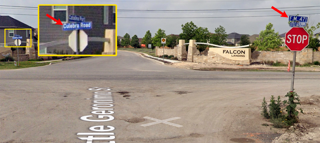
On the far northwest side of San Antonio is the intersection of Culebra Rd., Grissom Rd., and Tezel Rd. While it's not unusual to have three named roads intersect at a four-way intersection, what is unusual is that Culebra Rd. makes a 90-degree turn at this intersection, which many folks find confounding. Some even denounce it as some kind of error or oversight.
Additionally, there is also confusion over where Culebra Rd. ends and FM 471 begins. (Spoiler: They overlap.)
In both cases, today's seemingly odd arrangement is a collection of the artifacts of the various changes made to these roadways over the years. This page explains the history of those roads and why things are the way they are.
|
ADVERTISEMENT |
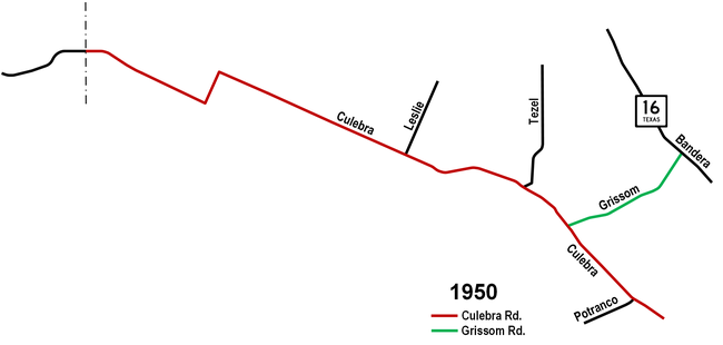
We start our history lesson in 1950 showing the orignial road network in this area. At this time, this area was entirely rural, and there was no Loop 410 (or even its predecessor Loop 13), Loop 1604, or SH 211. In fact, there were not even any FM roads in this area yet; those would be designated in a few years.
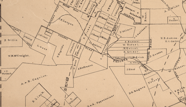
As you can see from the map, Culebra was a single road stretching from San Antonio all the way to the Medina county line. This is why the road west of Tezel Rd. today is named Culebra. And, as the map from 1897 below shows, it has carried that name for more than a century.
Grissom Rd. at this time dead-ended into Culebra Rd. at today's intersection of Culebra and Old Grissom Rd.
A couple of other items of note:
- Culebra Rd. made a couple of hard zig-zags just west of Galm Rd., which was called Hoffman Rd. until sometime in the mid 20th Century. That doglegged section is today's Old FM 471.
- Leslie Rd. ran where today's Loop 1604 crosses Culebra and ended there. After the original two-lane Loop 1604 was built, Leslie Rd. continued to parallel it just to the west. It would eventually be subsumed by the southbound frontage road when Loop 1604 was expanded to a freeway in the mid-2010s.
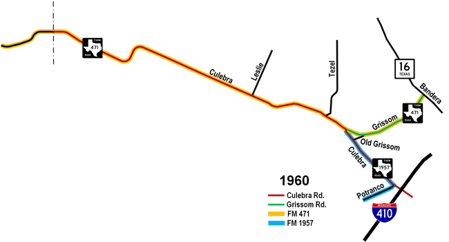
The next timepoint in our journey is 1960. In 1953, FM 471 was designated along Culebra Rd. and Grissom Rd. from Medina County to Bandera Rd. in Leon Valley. A new section of Grissom Rd. was built to streamline this route, connecting with Culebra Rd. at today's intersection of Grissom and Timber Path. Culebra at that time came up from the south to that intersection in the strip of land that is a hike/bike trail today and was slightly realigned to form a "T" intersection with Grissom. This now required making a 90-degree turn to continue along Culebra. The bypassed section of Grissom to the south became Old Grissom Rd.
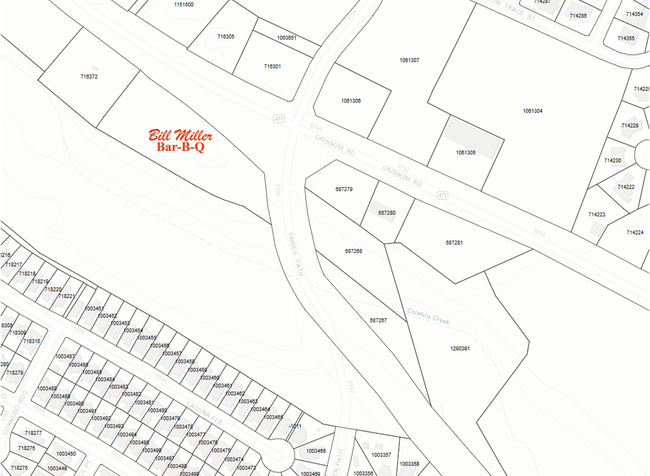
If you look at the intersection of Grissom and Timber Path today, you can still see the old right-of-way for Culebra from before the Grissom extension was built in front of Bill Miller's; it's used for a drainage channel today. (See image below.)
In 1954, FM 1957 was designated from today's intersection of Grissom and Timber Path southeast along Culebra to Potranco Rd., then west along Potranco.
Also of note during this time is that the sharp turns on Culebra west of Galm had been softened, and Loop 410 had been built and opened.
It's important to note that even though Culebra, Grissom, and Potranco were now designated as FM routes, they still also retained their original names, and still do to this day.
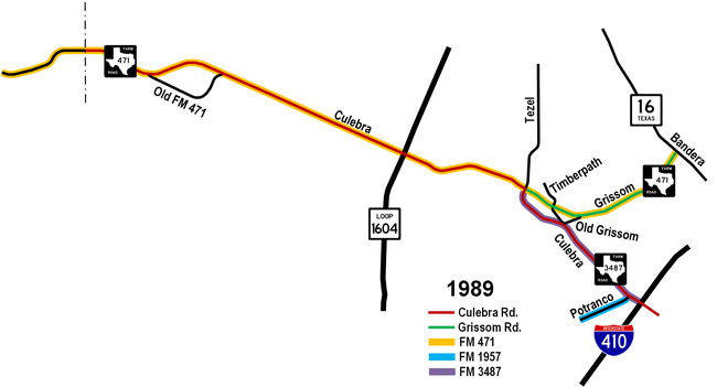
We skip forward now almost 30 years. Suburban development has now fully engulfed this area. As a result, the road system has been modified to better accommodate the new traffic patterns. Around 1987, Culebra was widened and the section north of Old Grissom Rd. was re-routed to the west to meet Tezel Rd., which itself had been straightened a decade or so earlier. The bypassed section of Culebra between Old Grissom and Grissom was simply made an extension of Timber Path.
With Culebra now moved to the west, the section of what was Culebra between Timber Path and Tezel was renamed to be part of Grissom Rd.
The FM road designations had also been modified. The section of FM 1957 along Culebra was re-numbered as FM 3487, with FM 1957 now running only along Potranco.
Other notable changes during this time include:
- FM 471/Culebra Rd. west of Galm had been re-aligned in the early '90s to bypass the doglegged section, which was renamed as Old FM 471.
- Loop 1604 made its appearance in this area in the early '70s.
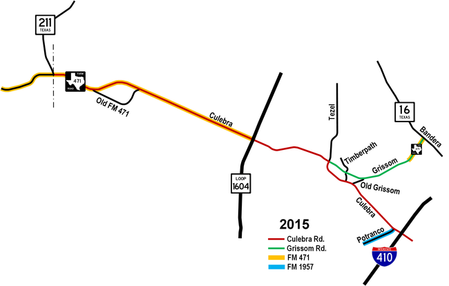
The last stop on our review is 2015, which is the current state of these roads. At the end of 2014, TxDOT made an agreement with the City of San Antonio to transfer ownership of several state roads to the city. One of these was FM 471 from Loop 1604 to the Leon Valley city limits, as well as all of FM 3487, and the FM designations of both of those segments were decommissioned. This means that all of Culebra Rd. inside Loop 1604 is now maintained by the city as well as Grissom Rd. outside of Leon Valley. The remaining section of FM 471 in Leon Valley was officially redesignated as Spur 471, but it remains signed as FM 471.
The other significant roadway change in this area was the realignment of Timber Path, connecting to Culebra about ¼ of a mile north of Old Grissom Rd. The section of Timber Path/old Culebra between Grissom and Old Grissom was then demolished. It is now a hike/bike trail that is part of the Leon Creek Greenway system.
Also during this time, SH 211 was built, with the section north of FM 471 opening in the early 1990s. The section south of 471 opened in 2022.
Summary
So to summarize, Culebra Rd. started as a single road from San Antonio to Medina County, but has been realigned over the years, first when a new section of Grissom was built to carry FM 471, then to meet Tezel Rd. to better accomodate the growing traffic needs of the area. Both of those changes created intersections that resulted in a 90-degree turn for Culebra. Because the road to the west had always been known as Culebra, it retained that name even when it was no longer continuous.
