|
||
|
|
||
This page updated January 19, 2026 |
Texas is a big place. It's nearly 880 miles from the Louisiana border near Orange to the New Mexico border near El Paso, and nearly 550 miles from the Oklahoma border north of Dallas to the Mexican border in Brownsville. That size gives the state a tremendous amount of diversity. A hot, humid sub-tropical climate in the Valley yields to a varying Midwest climate, complete with snow, in Amarillo. There are Piney Woods in East Texas, desert and low mountains in West Texas, and plains, prairies, and the Hill Country in between. The state has some of the nation's biggest metropolitan areas and some of its most desolate ranges. With this size and diversity, a large and rapidly growing population, a booming economy, an increasing role in international trade, and its overwhelming dependence on the automobile, Texas cannot help but have the nation's biggest, most well-developed highway system with nearly 80,000 miles of state-maintained roads.
This primer is designed to give you an overview of the state's highway system and its idiosyncrasies. If you're looking for a route log, check out Texas Highway Routes by David Stanek, a complete listing of all highways in Texas. Both Ron Jackson's TexasFreeway.com and Andy Field's LoneStarRoads sites have lots of in-depth information on freeways and other highways statewide.
|
ADVERTISEMENT |
On this page:
Texas highway facts
Highways in Texas are managed by the Texas Department of Transportation (TxDOT). TxDOT was created in 1991 from the former State Department of Highways and Public Transportation (SDHPT), which itself was created by the merger of the Texas Highway Department and Texas Mass Transportation Commission in 1975. After several earlier failed attempts, the original Texas Highway Department was born in 1917, mainly as a prerequisite in order for the state to receive federal highway funds. Prior to that, counties were responsible for building and maintaining a system of roads that connected county seats. Here are some basic facts about the state highway system in Texas:
| CENTERLINE MILES (2022) |
|
 |
3,466 |
 |
11,852 |
 |
16,443 |
 |
40,865 |
 |
351 |
 Frontage Roads |
7,927 |
| TOTAL STATE SYSTEM MILEAGE | 80,905 |
| TOTAL LANE MILES | 196,307 |
- First highway: Started in 1918 and finished in 1920, between Falfurrias and Encino in Brooks County, along present day US 281
- First Interstate: 1956, I‑45 (then US 75) near Corsicana in Navarro County
- Longest highway: US 83 stretches about 897 miles from the Oklahoma state line near Perryton to the Mexican border near Brownsville
- Shortest highway: Loop 168 in Tenaha, Shelby County, is one block long (~390 feet, 0.07 miles)
- Busiest highway: I‑10/Katy Freeway in Houston just east of Beltway 8 carries over 360,000 vehicles daily
- Highest highway: A spur from Texas 118 at the McDonald Observatory on Mt. Locke in West Texas is 6,791 feet above sea level
- Number of bridges: 54,488 (more than double the number of any other state); 35,676 of those are on the state system (2019)
- Longest bridges: The I‑45 viaduct near downtown Dallas is just under 2½ miles long, and the Queen Isabella Memorial Bridge at South Padre Island is 2.36 miles long
- Rest areas: 76
- Roadside parks: ~600
- Miles traveled daily on state highways: 574 million
State-maintained highways comprise about 25% of the total roadway mileage in Texas but carry about 74% of all traffic.
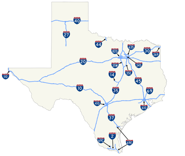
Interstates
In addition to having the nation's largest highway system overall, Texas also has more Interstate mileage than any other state. There are now 19 numbered Interstate Highways in the state:


Two of those are "hidden" or unsigned Interstates: I‑345, which is a short extension of I‑45 on the east side of downtown Dallas, and I‑110, which connects I‑10 to the Mexico border in El Paso.


Texas has two of the three "suffixed" Interstates in the nation (the other being I‑35 in Minneapolis-St. Paul). Coincidentally, I‑35 in Texas is also one of those suffixed routes. It splits at Hillsboro and Denton into I‑35E through Dallas and I‑35W through Ft. Worth. Prior to the early 1970s, several Interstates around the country that branched from primary routes were suffixed in this way, and I‑35 through the DFW area was one of those. However, a new policy in 1973 prohibited these "divided" numbers and required existing suffixed routes to be renumbered. But in the case of I‑35 in the DFW area (as well as in the Minneapolis-St. Paul area), because neither route was objectively the primary route and good arguments could be made for both, and because both forks returned to the main route on each end, I‑35E and I‑35W were allowed to keep their suffixed designations. The mileage and exit numbering for I‑35 follows I‑35E in both Texas and Minnesota, while I‑35W starts with mile 0 at the southern fork.
The second set of suffixed Interstates in Texas is I‑69. It is split three ways: first, it will fork into I‑69E and I69W at Victoria with I‑69E running south to Brownsville along US 77, and I‑69W continuing south to Laredo along US 59. I‑69C will then branch from I‑69W at George West and run along US 281 south to I‑2 at Pharr. Even though new suffixed designations were banned in 1973, the designations for I-69 were actually written into the federal law authorizing the routes. As a result, they were allowed to be numbered accordingly.
Interstates in Texas were generally built by upgrading existing US or State highways. I‑45 replaced US 75, I‑35 replaced US 81, and I‑40 replaced the famed US 66, to name a few. In urban areas, many existing expressways were simply re-signed as Interstates. The first Interstate contract let in Texas was for a segment of I‑45 in Navarro County near Corsicana in 1956. The latest additions to Texas' Interstate inventory are I‑2, I‑14, and I‑69. (See the I‑69 and I‑14 sections below.) Prior to that, the last Interstate to be completed was I‑27 between Lubbock and Amarillo in 1992.
I‑35 from the DFW Metroplex to San Antonio is the busiest Interstate corridor in Texas with no fewer than 65,000 vehicles per day on its rural sections between Hillsboro and Waco and higher counts as you go further south. As a result, this entire corridor has been upgraded to six lanes over the past two decades. A tollway to bypass Austin (SH 130) from Georgetown to I‑10 at Seguin was completed in 2012. TxDOT is also participating a federal study of I‑35 from Laredo to Duluth, Minnesota, which aims to provide comprehensive improvements to the entire corridor.
In addition to I‑35, TxDOT has projects underway or planned to widen the other two legs of the "Texas Triangle" (I‑10 between Houston and San Antonio, and I‑45 between Houston and Dallas) to six lanes over the next decade.
Besides increases in passenger vehicles, truck traffic on I‑35 and other Interstates has grown rapidly as a result of the North American Free Trade Agreement (NAFTA) and a resurgence in oil drilling in the state in the past decade.
Texas, like most states, switched from a sequential exit numbering system to a milepost numbering system in the mid to late '70s and early '80s. The exit number was typically posted on a tab above the exit board, but starting in 2012, signs with the exit number incorporated on the main exit sign began appearing.
In June 2001, the Texas Transportation Commission considered a major policy change that would have eliminated frontage roads from any new freeways unless absolutely necessary. This rocked many Texans to their core — enough so that after considerable pushback, the commission decided to scrap the idea.
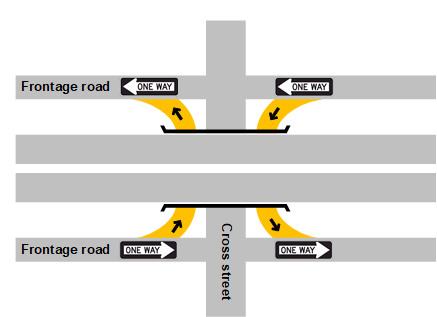
There are several ramp configurations used with frontage roads. The "diamond" interchange is typical, with the on- and off-ramps connecting to the frontage roads in the general shape of a diamond relative to the cross street (see illustration below.) Sometimes, the ramps are reversed in an "X"-interchange with the exit ramp for the next cross street preceding the entrance ramp from the previous cross street. This is generally the new standard in urban areas as it typically improves safety, reduces exit ramp backups onto the main freeways lanes, provides better access to and from frontage properties, and helps reduce through traffic at the the frontage road intersections, thus improving their operation. One drawback to the "X" configuration is a maneuver known as "sling-shotting", where drivers will use the configuration created by the ramps to enter the freeway and then immediately exit to either avoid the signal on the frontage road, or to bypass congestion on the main lanes.
 Frontage roads with diamond interchanges |
 Frontage roads with "X" interchanges |
Frontage roads with diamond interchanges |
Frontage roads with "X" interchanges
|
Occasionally, if space is limited, both the on and off ramps are built at the same location in what is known as a "braided" arrangement where one ramp passes-over the other.
The proximity of frontage roads to the main lanes of the freeway and the general lack of a barrier between the two invites the creation of something known as a "Texit", or "Texas Exit". This is where numerous vehicles have made their own off-ramp, either to avoid congestion, or because there is not an official exit ramp for the nearby intersecting roadway or the official exit is deemed inconvenient by some drivers. It should be noted that crossing the median between the freeway main lanes and a frontage road is illegal.
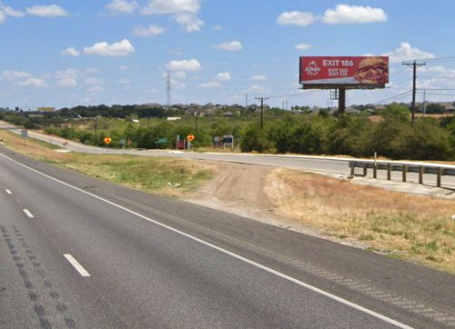
Speed limits on frontage roads generally range from 50-60 mph in rural areas and 40-50 mph in urban areas. In urban areas, frontage roads are typically one-way in the same direction as the adjacent freeway lanes. In rural areas they are generally two-way. By law, traffic leaving or entering the freeway has the right-of-way over traffic already on the frontage road.
It should be noted that frontage roads are not just found on Interstates — you'll find frontage roads on freeways regardless of route classification (i.e. Interstate, US, or SH routes).
Native Texans are frequently surprised when they go to other places and find no frontage roads. A comment many make after their trip to another state is, "they don't have frontage roads on their highways!" But many native Texans don't realize how much of an idiosyncrasy our extensive frontage roads are. Conversely, many out-of-state visitors immediately notice and comment on our frontage roads (with no clear majority observed by this author between thumbs-up and thumbs-down).
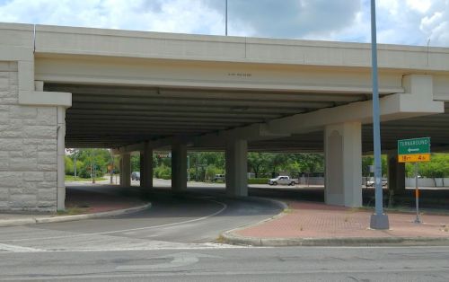
 Going hand-in-hand with frontage roads are the so-called "Texas U‑turns" or "turnarounds". These are separate U‑turn lanes that allow traffic heading in one direction on a one-way frontage road to reverse course and head the other way on the opposite frontage road without having to pass through the two frontage road/cross street intersections (see diagram below.) This reduces congestion and conflicts in those intersections. Where the cross street passes under the freeway, the turnaround is typically in the same underpass. Where the cross street passes over the freeway, turnarounds can either share the same overpass as the cross street (physically separated from the main road) or have their own separate overpasses.
 Turnarounds are only used on one-way frontage roads and therefore are generally found only in urban areas. Like frontage roads, these may have different names in different parts of the state, although "turnaround" seems to be the predominate term. Most of the state uses the "U‑turn ONLY" sign to mark them, although the "turnaround" sign is used in some places. Other terms used for turnarounds are "U‑turn lane" and "crossover", although the later more correctly describes an opening in the median on a divided highway.
 With the growth of NAFTA traffic, Congress approved a High Priority Corridor in the 1991 federal transportation bill that would extend Interstate 69 from Indiana southwestward to and through Texas. In Texas, the corridor would run from Texarkana through Houston and on to Laredo. Two extensions running to the lower Rio Grande Valley were added in 1995 and 1998. "Future I‑69" signs began appearing on US 59 in the Houston area in 2000.
During the first decade of this century, planning for most of I-69 was rolled-into the Trans-Texas Corridor as "TTC‑69" (more details on the TTC below). However, after the demise of the TTC, the I‑69 project was continued as a standalone effort.
In keeping with Texas' past development of Interstates — and due to opposition from environmental and property rights groups for a "greenfield" route — I‑69 will upgrade the existing US 59, US 77, and US 281, with new alignments mainly for bypasses around towns along the route.
I‑69 will be unique in that it is the only Interstate with three suffixed forks. South of Victoria, I‑69 forks into two routes: I‑69E along US 77 south to Brownsville, and I‑69W, which continues south along US 59 to Laredo. Near George West, another branch, numbered I‑69C, splits off of I‑69W and follows US 281 south to Pharr. These suffixed designations were actually written into the federal law authorizing the new routes. Ostensibly, this was done to not show any preference or supremacy for one of terminus cities over the others.
In August 2011, the Federal Highway Administration approved Texas' request to sign the first section of I‑69 in the state and, four months later, the first I‑69 signs went up on a 6.2 mile section of the US 77 expressway between I‑37 and Robstown just west of Corpus Christi. Those first signs were I‑69, but were later changed to I‑69E when that route number finally received federal approval. In September 2012, 35 miles of US 59 stretching from Loop 610 in northeast Houston to the Montgomery/Liberty county line was also signed as I‑69. Since then, numerous additional sections have been signed as they have been upgraded to Interstate standards and, as of 2023, there were about 250 miles of I‑69 signed in Texas.
 As part of the I‑69 project, the federal government also approved signing US 83 through the Rio Grande Valley — which was already at Interstate standards — as I‑2, connecting I‑69C at Pharr with I‑69E at Harlingen.
More information on I‑69 in Texas is available at the Alliance for I‑69 Texas website.
 In December 2015, the US Congress passed legislation that approved the designation of another new Interstate in Texas, I‑14. Nicknamed the "Forts-to-Ports" route, this route was proposed by the Gulf Coast Strategic Highway Coalition and is intended to provide a high-speed east-west corridor through the middle of the state connecting Ft. Bliss and Ft. Cavazos In Texas with Ft. Johnson in Louisiana, and connectivity via other existing highways to the military ports in Beaumont and Corpus Christi. I‑14 is planned to subsume most of the current route of US 190 from West Texas to the Louisiana border east of Jasper, connecting Brady, Killeen, Belton, Bryan, Huntsville, and Livingston. Some portions of the route have not yet been finalized including the section from Bryan to Huntsville and the routing west of Brady.
While the official designation currently calls for I‑14 to join with I‑10 in West Texas, planners are looking at possibly routing it northwest from Brady through San Angelo to Midland/Odessa. As with I‑69, it is possible that both legs may eventually be built. Also like I‑69, I‑14 will be built piecemeal by upgrading segments of the corridor to Interstate standards as funding becomes available.
The first signs for I‑14 were installed in April 2017 along the existing US 190 freeway between Copperas Cove and I‑35 at Belton.
More information on I‑14 is available at the Gulf Coast Strategic Highway Coalition website.
 TxDOT commissioned a study during the mid '90s to investigate extending I‑27 south from Lubbock. Three corridors were considered: US 87/SH 349 to Midland, a Sweetwater-San Angelo-Junction corridor connecting to I‑10, and another corridor through Big Spring to I‑10 at Ozona. The study concluded that there was not enough traffic at that time, or projected, to warrant an extension of I‑27 for the foreseeable future. Instead, a package of upgrades to US 385, SH 349, US 87, and US 84 was recommended.
Over the years, additional studies have been done on this "Ports-to-Plains" corridor. Those reports have also concluded that, while there is support from many stakeholders for an Interstate, an upgrade to a full Interstate is still not warranted in this corridor. Instead, various options including bypasses, intersection improvements, additional lanes on existing roads, and ITS measures were recommended.
During the 2019 Texas legislative session, a bill was passed and later signed into law that directed TxDOT to once again study an extension of I‑27 from Lubbock to Laredo. And in 2022, Congress passed a law designating the entire corridor from Laredo to Raton, New Mexico, as future Interstate 27.
In 2024, TxDOT completed its study and developed an implementation plan to upgrade the corridor to Interstate Highway standards. Like I‑35, there will be two branches of I‑27 where it crosses I‑20: I‑27W through Midland, and I‑27E through Big Spring. The corridor will also split again at Dumas, with the main I‑27 turning west to Raton, NM, and I‑127N continuing north to Limon, CO. You can see the latest updates at the Ports-to-Plains coalition website.
State highways
 The State Highway system includes State Highways (SH), Loops, and Spurs. There are also Park Roads and Business Routes, as well as a few "one-off" designations: OSR (Old San Antonio Road) near Bryan, NASA Road 1 leading to the Johnson Space Center, and Beltway 8 around Houston.

Secondly, on US business routes, TxDOT often does not use the "BUS" or "BUSINESS" plaque mounted above the US route marker. Rather, the word "BUSINESS" is frequently integrated within the US shield above the number, as shown to the right above.
 Business Interstate Loops were fairly rare in Texas until the state decommissioned all US highways that were completely concurrent with Interstates in 1991. Along those Interstates, the US route had previously provided the parent route for the business routes. For example, where I‑35 and US 81 coexisted, the business route through towns along the way were designed as Business US 81. Those have since been replaced with Business Interstate Loops.


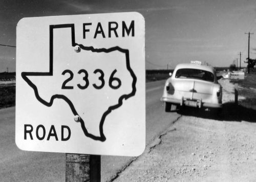
Farm-to-Market roads
 Nearly half of the state's highway system is comprised of the Farm-to-Market (FM) road system, which also includes Ranch-to-Market (RM) roads. Although the first FM road opened in Rusk County in 1937, the system really grew after the 1949 Legislature set aside $15 million annually (or about $205 million in today's dollars) for their construction to "help get farmers out of the mud." The system is generally considered to be the largest secondary highway system in the world. Its nearly 41,000 miles is more than double the entire state highway mileage of the six New England states combined. All FM roads are paved and most are two lanes.
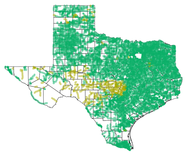
 Out of the 3,550 routes in the FM/RM system, 3,370 are labeled as FM, leaving just 180 routes designated as RM. The bulk of those are in a large cluster in the Hill Country and Edwards Plateau area west of Austin and northwest of San Antonio. There are also several RM roads in West Texas and the Panhandle, and a few others widely scattered in the rest of the state. (See map below.)
The exact FM vs RM naming criteria is an enigma (there may not actually be an official rule), but a couple of theories have been proffered. One is an assumption is made by TxDOT on the type of traffic one is more likely to see along a particular road — e.g. more livestock trailers traveling RM roads, and more farm equipment like combines and tractors plying FM roads. Another possibility is simply local traditional vernacular.
In addition to the regular FM and RM routes, there are even three FM Spur routes and three Business FM routes.
FM and RM roads are numbered as a single system, i.e. there is not an FM and RM road with the same number.
 The new routes would keep the same route number as the previous FM or RM designation. However, new signage was proposed. The planned sign would have been the simple state highway square with the word "urban" and the route number (see the example at left.) However, an unexpected uproar from the public about changing the much-beloved Texas-shaped sign — as well as the perceived unnecessary the expense of doing so — eventually stopped the "un-Texan" plan to re-sign the roads. Instead, TxDOT's internal highway designation logs were changed as planned to re-classify those urban segments as UR, but the existing FM and RM signs were left in place.
By 2018, there were 251 roadway segments classified as UR. However, the idea apparently never really accomplished its stated objectives and was never fully implemented. Instead, the inconsistent designations seemed to just cause confusion. So in November of 2018, the Transportation Commission dissolved the Urban Road designation and the routes were returned back to the FM system.
|
ADVERTISEMENT |
Innovation
Texas has always been on the leading edge of highway technology. The Texas Transportation Institute (TTI) at Texas A&M University has spearheaded much of this highway research. Here are some of the many innovations to come from Texas:
- The "Texas Twist" guardrail end was developed in the 1970s to deflect vehicles by burying the ends of the guardrails. As cars got smaller, though, many overturned when hitting this. So in the late '80s and early '90s, TTI developed a new guardrail end treatment called the ET2000. This new guardrail end absorbs the impact of a vehicle by extruding the rail and breaking the wooden posts. (You can see an example of this in the PA route sign photo above.)
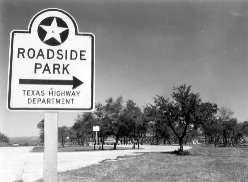
- Texas initiated the concept of roadside parks. The first such facility opened in 1933 along SH 71 between Smithville and La Grange. In recent years, though, funding and maintenance issues, as well as the proliferation of truck stops and similar facilities, has resulted in Texas closing an increasing number of picnic and rest areas, especially near urban areas.
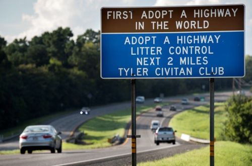
- The "Adopt-a-Highway" project was developed in Texas in 1985, and it was the first state to implement it statewide. Every other state but one has since emulated this program. There are currently about 3,300 groups collecting litter along 8,000 miles of highway. It is estimated that this program saves the state $3 million a year in litter clean-up costs. (Also see the "Don't Mess With Texas" section below.)
- Breakaway sign posts and streetlights were developed in a two-year program in the 1970s to reduce the seriousness of roadside object impact accidents.
After 125 crashes resulted in not one single injury, the federal government mandated their use on all federally-funded roads. Texas also developed the breakaway "coat hanger" rural mailbox support, which was recently redesigned.
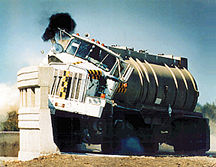
- A modified version of the standard Jersey-barrier — called a "constant slope" barrier — designed to reduce the likelihood of smaller vehicles flipping over on impact was developed in the 1980s by TTI. TTI also designed a special heavy-duty, extra-tall bridge rail for a downtown San Antonio freeway ramp to prevent heavy trucks from crashing down onto a high school football field below. To test it, they crashed a fully-loaded tanker truck into it! This rail design has since been used in many other locations where extra strength crash-barriers are needed.
Don't Mess With Texas ®
 During the mid '80s, the forerunner of TxDOT introduced what would become an incredibly popular anti-litter campaign: "Don't Mess With Texas". Signs went up around the state and the slogan went viral. Today, you can get "Don't Mess With Texas" T-shirts, mugs, stickers, keychains, hats... you get the idea. There have also been numerous "Don't Mess With Texas" commercials featuring various celebrities. You can view these on TxDOT's website.
TxDOT owns the trademark on the slogan and logo and zealously pursues unauthorized uses.
Intelligent Transportation Systems (ITS)
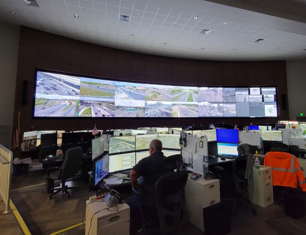
With freeways expansions becoming increasingly expensive, the Texas Transportation Commission in 1989 committed to building Intelligent Transportation Systems (ITS) in the state's largest metro areas. These systems use various technologies to monitor traffic conditions and warn drivers of incidents and congestion. ITS also plays a major role in hurricane evacuations and other emergency situations.
The first system to go online was TransGuide in San Antonio, which at the time was the first advanced freeway ITS system in the nation. TransStar in Houston followed shortly thereafter. All of the state's metro areas now have ITS systems, and it has been expanded to several busy rural corridors as well. As of 2020, the state's 14 traffic management centers operated almost 1,000 dynamic message signs and nearly 2,900 traffic cameras.
Signage
With the largest highway system in the nation, it's no surprise that Texas has more road signs than any other state. There are over 500,000 signs on state maintained highways.
Texas might be the only state that has two different versions of its route markers: One version for freestanding signs, and another for use on freeway guide signs. Here are some examples:
| STANDALONE SIGNS | GUIDE SIGN SHIELDS | |
|
 |
|
|
 |


Toll roads
 Until the early 2000s, Texas law prevented the state from building or operating toll highways. Instead, they could be built and operated by subsidiaries of TxDOT or independent agencies created specifically for that purpose. For instance, the Texas Turnpike Authority built and operated tollways in the Dallas area, including the Dallas-Ft. Worth Turnpike, which was the state's first toll road. North Texas tollways are now operated by North Texas Tollway Authority, while the Harris County Toll Road Authority has built and operates several tollways in the Houston area (see sidebar below.)
In the late '90s, a private toll road, called the Camino Columbia, was built to connect the Columbia Solidarity Bridge northwest of Laredo to I‑35. Due to a lack of traffic caused by federal delays to implementing the trucking rules of the North American Free Trade Agreement (NAFTA), that road eventually was sold to the state and is now operated by TxDOT.
In the early 2000s, with worsening urban congestion and declining revenue from the static state gas tax, the state promoted toll roads as the major mechanism to fund new or expanded freeways. To facilitate this in areas without existing toll authorities, the legislature authorized the creation of so-called Regional Mobility Authorities (RMAs). Toll roads quickly became a hot-button issue. Perhaps the most controversial toll road proposal was the statewide Trans-Texas Corridor project (see below.)
Toll roads in Texas are marked with special route shields such as the one shown to the right above.

|
The Sam Houston Tollway around Houston is also referred to as Beltway 8. However, only the frontage roads along most of the route are actually Beltway 8, which is a state highway. The tolled mainlanes are just the "Sam Houston Tollway", which is operated by the Harris County Toll Road Authority. While it is officially titled "Beltway 8" and signed as such, it is actually listed in the state's highway designation files as State Loop 8. The "Beltway" designation was assigned as it had been called the "Outer Belt" by Houston officials since its inception. |
|
ADVERTISEMENT |
Trans-Texas Corridor
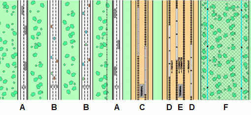
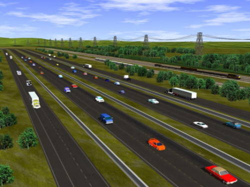
![]() In 2002, Texas Governor Rick Perry announced a concept for a massive new transportation system in Texas. The plan, called the "Trans-Texas Corridor" (TTC), was subsequently approved by the legislature and called for 4,000 miles of superhighway/rail/utility corridors crisscrossing the state. As envisioned, each corridor would be 1,200 feet wide and included separate roadways for passenger vehicles and trucks, separate tracks for freight and passenger rail, and right-of-way for utilities such as gas, oil, and water pipelines and electrical transmission and telecommunications lines. Specifically, here's how a typical corridor would have been divvied up:
In 2002, Texas Governor Rick Perry announced a concept for a massive new transportation system in Texas. The plan, called the "Trans-Texas Corridor" (TTC), was subsequently approved by the legislature and called for 4,000 miles of superhighway/rail/utility corridors crisscrossing the state. As envisioned, each corridor would be 1,200 feet wide and included separate roadways for passenger vehicles and trucks, separate tracks for freight and passenger rail, and right-of-way for utilities such as gas, oil, and water pipelines and electrical transmission and telecommunications lines. Specifically, here's how a typical corridor would have been divvied up:
- Four truck lanes, two each way (A on the diagram below)
- Six passenger vehicle lanes, three each way (B)
- Two sets of tracks for high-speed passenger rail, with stations (C)
- Two sets of tracks for freight rail (D)
- Two sets of tracks for commuter rail, with stations (E)
- A utility corridor about 200 feet wide (F)
- Maintenance, safety, and expansion zones as necessary
The roadways would have had limited interchanges with exits only at intersections with other TTC routes, Interstates, US highways, and major state highways. It was planned that the passenger roadways would have speed limits of 80 mph.
There were four priority corridors:
- TTC‑35, to parallel or overlap I‑35 from Denison to Laredo
- TTC‑69/future I‑69, from Texarkana to Laredo via Houston, with branches to the Lower Rio Grande Valley
- I‑45 from Dallas to Houston
- I‑10 from El Paso to Orange
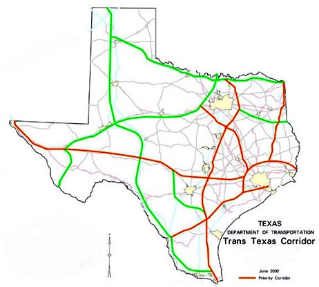
The corridors would have been developed and operated by private companies under a state franchise. These companies would charge tolls and fees for users.
The project, however, met with fierce opposition across the state. Opposition was especially pronounced in rural areas as the wide corridors would have taken many acres of farming and ranch lands. Furthermore, there was a general discontent with the concept of having the roads operated by private companies, especially ones with foreign ties.
As a result, the project was killed by the Legislature in 2009. The TTC‑35 and TTC‑69 projects, which were in advanced planning at the time, continued but not under the TTC brand, and the TTC‑35 project was also eventually cancelled. However, the segment from Georgetown to Seguin, which had been conceived as a traditional toll project prior to the TTC, was allowed to be completed as a regional project and is today's SH 130. Planning for TTC‑69 (the I‑69 extension) has continued as a traditional non-toll Interstate project (see I‑69 above.)
Speed limits
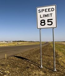
Texas is the only state that does not have statutory speed limits for the different categories of highways in the state system. Instead, a general limit of 70 mph applies on any rural numbered highway regardless of classification or number of lanes, and 60 mph on any other rural roadway. A 30 mph general limit applies in urban areas. These limits can be raised or lowered on specific segments based on an engineering study. Speed limits can be raised to 75 mph on numbered highways, and up to 85 mph on select roadways. This means Texas is the only state that has 75 mph speed limits on two-lane roads.
As speed limits have been increased across most of the US in recent years, Texas has lead the way. Today, Texas has an 80 mph speed limit on about 520 miles of I‑10 and I‑20 in west Texas. Several tollways in the Austin area also have an 80 mph speed limit, and SH 130 from SH 45 south of Austin to I‑10 near Seguin has an 85 mph speed limit — the highest in the United States.
Tunnels & ferries
TxDOT operates two ferry services. The longest is on SH 87 from Galveston to Port Bolivar. Another short ferry connects Port Aransas and Aransas Pass on SH 361. The Harris County Toll Road Authority (HCTRA) also operates the Lynchburg Ferry east of Houston near San Jacinto State Park. HCTRA studied a possible bridge to replace the Galveston-Bolivar ferry, but determined it to not be feasible.
There are currently no tunnels on the state highway system. At one time, TxDOT did operate a tunnel under the Houston Ship Channel on SH 146 between La Porte and Baytown. It was replaced in the early '90s by the impressive cable-stayed Hartman Bridge. There are, however, three road tunnels in Texas that are not part of the state highway system: the Washburn Tunnel, which is also under the Houston Ship Channel on Federal Road; the Addison Airport Toll Tunnel in Addison north of Dallas (operated by NTTA); and one in Big Bend National Park.
Other sites of interest
|
|
Texas Department of Transportation http://www.txdot.gov |
|
|
Don't Mess With Texas campaign http://www.dontmesswithtexas.org |
|
|
I-14 System in Texas https://www.txdot.gov/projects/projects-studies/statewide/interstate-14-system-in-texas.html/ |
|
|
I-27 System in Texas https://www.txdot.gov/projects/projects-studies/statewide/i27-system-in-texas.html/ |
|
|
I-69 System in Texas https://www.txdot.gov/projects/projects-studies/statewide/interstate-69-system-in-texas.html/ |
|
|
Port-to-Plains Coalition http://www.portstoplains.com/ |
|
|
Alliance for I-69 Texas http://www.i69texasalliance.com |
|
|
Other Texas "Roadgeek" sites See the list on my main Texas page: https://www.texashighwayman.com/tex.shtml |