|
||
|
|
||
This page last updated July 27, 2025 |
TransGuide is San Antonio's award-winning, inter-agency Advanced Transportation Management System. When it went online in July 1995, it was the most advanced system of its kind in the nation, and it continues to be a leader in Intelligent Transportation Systems (ITS) technology.
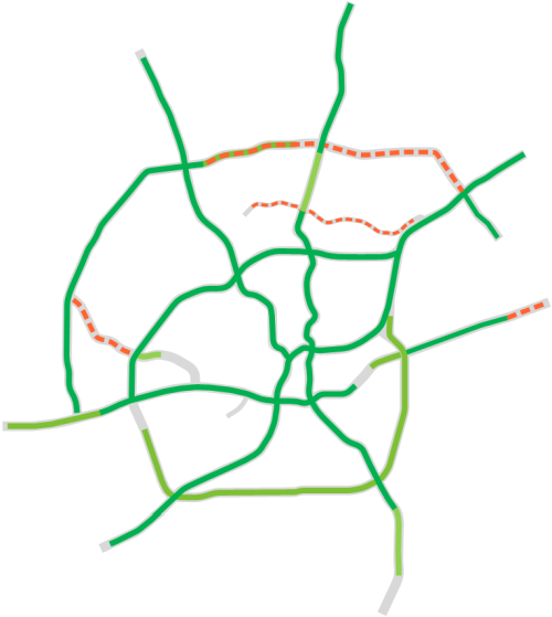
The system is now operational on about 200 miles of freeway in Bexar County and is currently under construction on about 30 additional miles. Below is a map of TransGuide's current coverage area and planned future expansions. "Full coverage" areas shown on the map are the areas with comprehensive coverage of cameras, traffic monitoring, and message signs. "Auxiliary coverage" areas have more widely-spaced cameras and message signs; these can be thought-of as "TransGuide Lite" areas. Some of these areas are planned for future upgrades to full coverage.

|
ADVERTISEMENT |
On this page:
History
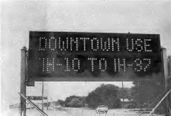
In 1978, a two-year pilot project began in San Antonio to study the use of digital message signs to warn motorists of traffic incidents and recommend use of an alternate route. This project, called the Motorist Information and Diversion System, used two temporary trailer-mounted digital signs along northbound I‑35 between SW Military Dr. and Division Ave. on the South Side to warn drivers of incidents along the downtown section of I‑35 and recommend detouring around the east side of downtown instead. This section of I‑35 was selected as the Highway Department was looking for interim solutions to manage traffic there prior to and during the project to double-deck I‑35 through downtown.
By today's standards, the system used pretty clunky and arcane technology. When an incident occurred, police officers in the field would manually reference a printed matrix to determine which message to display on the signs, then relay that to the dispatcher, who would then use a use a teletype device to dial-up the signs individually and manually enter the corresponding message code. The final report on the project recommended developing more user-friendly equipment to select and implement the messages and to use dedicated communications lines. Overall, the study showed a potential benefit to the signs and suggested further study. After the study ended, the signs continued to be used during the construction, with one of the signs subsequently relocated to southbound I‑35 near Walters St.
Over the past two decades, the full coverage system has been gradually expanded:
- 1999: US 281 from St. Mary's St. to Basse Rd., Loop 410 from Ingram Rd. to I‑35 North, I‑10 from Fulton Ave. to Camp Bullis Rd., and Loop 1604 from Babcock Rd. to Lockhill-Selma Rd.
- 2000: I‑35 from New Braunfels Ave. to Starlight Terrace
- 2001: US 90 from Zarzamora St. to Hunt Ln.
- 2002: I‑37 from Fair Ave. to US 181
- 2003: I‑35 from Starlight Terrace to Loop 1604, and Loop 1604 from I‑10 to Bandera Rd.
- 2009: US 281 from Basse Rd. to Nakoma Dr., and Loop 410 from Ingram Rd. to Culebra Rd.
- 2012: US 281 from Nakoma Dr. to Winding Way
- 2016: Loop 1604 from Bandera Rd. to Culebra Rd.
- 2019: Loop 1604 from Culebra Rd. to US 90, and Loop 410 from Culebra Rd. to SH 151
- 2020: Loop 410 from SH 151 to US 90
- 2021: I‑10 from Loop 1604 to Ralph Fair Rd.
- 2022: Loop 1604 from I‑35 to FM 78
- 2023: US 281 from Loop 1604 to Borgfeld Dr., and I‑35 from Southcross Blvd. to Loop 1604
- 2025: Wurzbach Parkway from NW Military Hwy. to Weidner Rd.
In 2008, in coordination with TxDOT's Austin district, ITS coverage was extended to the entire I‑35 San Antonio-Austin corridor as the first such intercity project in the state. TransGuide is responsible for the section south of the Comal/Hays County line with Austin's ITS system taking it from there.
In 2009, TransGuide completed the first major upgrade of their computer systems and website.
In 2017, dynamic message signs and cameras were installed at strategic locations along I‑10 between San Antonio and Ozona.
In 2003, TransGuide established direct fiber-optic feeds to the local TV stations along with the capability for them to select specific camera feeds for their broadcast. Shortly thereafter, the UHF transmitter was shut down.
- Development of a wireless data system (similar to today's Wi‑Fi) that permitted two-way videoconferencing and data transfer between EMS ambulances and hospitals using the TransGuide infrastructure.
- Installation of interactive traveler information kiosks at key locations around the city that provided real-time traffic information as well as weather reports, bus and airport information, and tourist information.
- Development of in-vehicle navigation units that displayed real-time traffic and incident information as well as turn-by-turn directions. (This was a predecessor to today's GPS apps.)
- Expanded real-time travel speed data collection using RFID tags distributed to volunteers and read by antennas placed over traffic lanes at strategic locations around the city. This data was consolidated into a regional database that also included data from TransGuide's traffic monitoring, SAPD accident data, and TxDOT lane closure information. This database was used by the information kiosks and in-vehicle navigation units.
- Creation of the Advanced Warning to Avoid Railroad Delay (AWARD) system that installed detection equipment at railroad crossings near freeway exits which allowed drivers to be alerted of delays caused by trains.
Several of these technologies are commonplace today but were quite innovative for their time as that was before the ubiquitous Internet access, GPS, public traffic data, and Wi‑Fi that we have today. The MDI program ended in 1999.
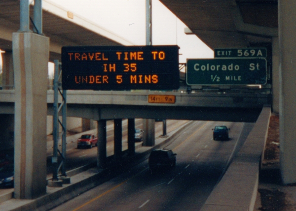
Initially, travel times were displayed from 6:00 am to 10:00 pm. The first generation of travel times just showed the destination and a travel time range. A subsequent improvement added the corresponding distance, which allows drivers unfamiliar with the route to better correlate the time to distance and therefore assess downstream conditions.
System components
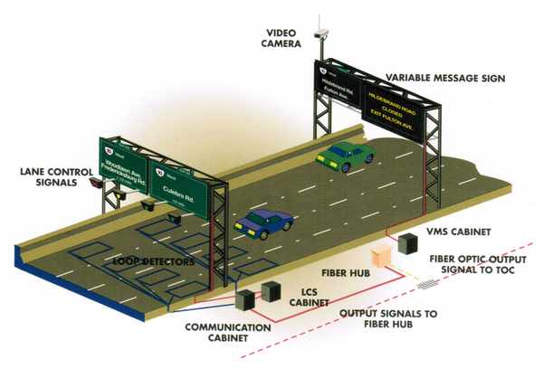
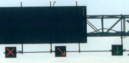
When it was first developed, the specifications called for TransGuide to be able to reliably detect incidents within two minutes, quickly verify the incident, and then be able to implement a response scenario that would update the dynamic message signs and lane control signals within 15 seconds. To accomplish these goals, TransGuide uses a variety of technologies, and the system today is composed of the following major components:
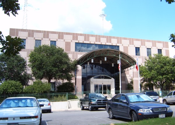
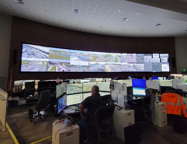
- Three-story traffic operations center (TOC)
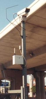
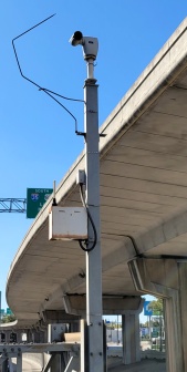
- Approximately 250 closed-circuit, remote-controlled video cameras
- Traffic detectors at over 200 locations (originally inductive loop detectors in the pavement, but mostly side-fire radar and Bluetooth readers nowadays)
- Approximately 135 mainlane dynamic message signs (DMS)
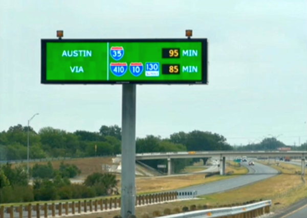
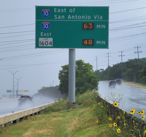
- 17 travel time comparison (TTC) signs
- Dedicated divergently-routed fiber-optic rings, wireless transmitters/receivers, and associated communications equipment
- Redundant and distributed data systems, specialized software, and related equipment
In 2009, the City of San Antonio established their own Transportation and Infrastructure Management Center in the TransGuide building from which they monitor traffic on major arteries and manage the operation of the city's more than 1,400 traffic signals. Previously, COSA's center was in a separate room from TxDOT's, but after a renovation in 2021, the city and state centers were combined in order to improve coordination and efficiency between them.
From around 2010 until 2017, the regional office for the Texas Department of Motor Vehicles (which was spun-off from TxDOT in 2009) was housed in the TransGuide building. It has since moved to a location on Nacogdoches Rd.
When it was originally built, the building was inside of — and accessible only from — one of the interchange's cloverleaf ramps. The cloverleaf has since been removed, and today the building is accessible from the eastbound Loop 410 access road.
|
|
Due to funding shortages in the early part of this century, maintenance and expansion of the traffic monitoring systems took a back seat to maintenance of cameras and DMSs. Today, while some side-fire radar and Bluetooth tracking are still in use, commercial GPS traffic data is the now primary source of traffic data.
In addition to the standard mainlane DMSs, TransGuide also originally deployed frontage road DMSs at on-ramps, which was unique to San Antonio. However, as with lane control signals (see below), funding shortages have resulted in the frontage road DMSs being deactivated and, in many cases, removed, and there are currently no plans to restore them.
Current and future expansions and upgrades will include full-color, full-matrix DMSs, which will allow for more flexible messages including reproductions of official traffic signs and other symbols. The first such DMS in the state was installed on I‑35 near Benton City Rd. in Von Ormy, and several of these are now in use around the city.
A study in 2007 showed about an 80% compliance rate with LCS and DMS messages. (Perhaps another corollary of the old 80/20 rule.)
Current and future expansions and upgrades
Ongoing funding shortages during the first two decades of this century delayed expansion plans for the system and resulted in a substantial backlog of deferred maintenance. This funding shortage resulted in the decision to permanently disable the system's lane control signals and frontage road dynamic message signs in 2009 as discussed above. However, recent increases in funding have allowed for renewed expansion of the system and a program to clear the backlog of deferred repairs, upgrades, and expansions. The 2021 winter storm highlighted the importance of ITS and is driving additional improvements and expansions.
The system is currently being expanded into new areas in conjunction with major freeway construction projects along Loop 1604, I‑10 East, and SH 151, and work was recently completed to add auxiliary coverage along Wurzbach Parkway. Additionally, cameras are being installed on I‑37 in Atascosa County and on I‑10 between Seguin and Luling, primarily for monitoring during hurricane evacuations. Future expansion of the full-coverage system is planned as part of the US 90 West expansion projects and the future phases of the I‑10/Loop 410 East interchange project.
Current and future expansions and upgrades will include full-color, full-matrix DMSs which will allow for more flexible messages including reproductions of official traffic signs and other symbols. Several of these are now in use around the city.
Work is currently underway to make streaming video from the cameras available on the TransGuide website.
Wrong-way driver initiative
 In 2011, after a series of wrong-way driver incidents culminating in the death of a San Antonio Police Department officer, a task force was established to combat the local wrong-way driver (WWD) problem. The task force included TxDOT, SAPD, the City of San Antonio Public Works department, the Bexar County Sheriff's Office, the Federal Highway Administration, and the Texas Transportation Institute. Their charge was to identify local WWD hot spots, analyze previous WWD research, investigate WWD countermeasures implemented elsewhere and determine those that could be implemented locally, and identify funding for a WWD countermeasures program.
The task force identified several countermeasures to implement including enhanced signage and pavement markings, active/illuminated signage, and detection technologies. In 2012, TxDOT began work on a pilot project to install flashing LED wrong way signs on all 29 exit ramps on US 281 north of downtown. That was followed in 2013 by installation of flashing LED wrong way signs and WWD detection radar as part of a larger expansion project on I‑35 in the Selma area. Later in 2013, WWD radar was installed on the US 281 locations, and testing of a mainlane WWD detection and warning system was completed at the Southwest Research Institute. That system detects wrong way drivers using radar, then illuminates multiple wrong way signs to alert the driver. All the ramp and mainlane WWD radar systems notify operators at TransGuide when a WWD is detected. TransGuide operators then dispatch police and activate warning messages on the DMSs along the route to alert drivers.
In addition to the above, other countermeasures that have been implemented include red reflective tape added to the wrong way signposts to increase their visibility, adjustments to the locations of the reflectors used in off-ramp pavement arrows to reduce loss due to repeated contact, and additional, repositioned, and/or larger signage where warranted.
The results of the US 281 pilot project were significant with a 29% reduction in WWD events recorded in the year after the changes were made. Since then, the system has been improved and expanded to most freeways in the area. Newer installations include multiple radar units as well as a camera. When a WWD is detected, the camera takes a picture, which is then included in the automated notifications to TransGuide and SAPD. SAPD now also announces WWD incidents over their radio with an emergency tone.
Between 2011 and 2018, the local WWD system detected and helped stop 67 wrong way drivers. TxDOT continues to refine, improve, and expand the system.
- Spike strips are designed for very low-speed locations (<10 mph). During testing with high-speed vehicles as would be found on exit ramps, the spikes often broke, leaving stubs that damaged the tires of vehicles traveling the right direction.
- The strips are hazardous to motorcycles, especially when wet.
- Dirt and debris build up in the devices over time, which prevents the spikes from folding down properly and therefore can damage the tires of vehicles passing over in the right direction or even cause drivers to lose control. Freezing precipitation can also cause this.
- Some drivers may view the strips as a hazard and suddenly reduce their speed, causing congestion and increasing the chances for rear-end collisions.
- Emergency vehicles sometimes have to travel on exit ramps in the wrong direction to more quickly reach accident scenes.
In short, although it seems like an obvious solution to the WWD problem, spike strips have too many "fatal flaws" to be a bona fide option.
HERO program
The Highway Emergency Response Operation (HERO) program, which patrols the local freeways to assist stalled motorists, clear debris, and provide traffic control at crash scenes, is operated out of TransGuide. More details on the HERO program is on the freeway primer page.
Benefits and accolades
Several studies have proven the benefits of ITS systems in the form of reduced secondary collisions, mitigated congestion (and all that entails) due to expedited incident clearing and timely driver information, and, most importantly, lives saved. Here are some statistics from one report that did a before-and-after study of the first phase of TransGuide:
- 41% reduction in crashes, including a 15% decrease in injury accidents
- 20% reduction in response times to incidents
- Annual savings of $1.65 million in time and fuel
- 2,600 gallon fuel savings per major incident
- Increase in driver compliance to posted instructions from 33% to 80%
- 88% of drivers reported DMS signs were "very easy" to understand
- 85% of drivers indicated that TransGuide was an efficient way of managing congestion and notifying motorists
- 80% of drivers felt TransGuide was a good use of tax dollars
(Source: Texas Transportation Institute Study, 1997)
Through the years, TransGuide has received many accolades and awards recognizing its innovation and operation, including being named by the Federal Highway Administration in 2000 as the most advanced and innovative ITS system in the United States, and being awarded a National Roadway Safety Award in 2015 for its wrong-way driver detection and warning system.
FAQ
- What's the point of TransGuide? All it ever tells me about is congestion that I see everyday and already know about.
Yes, it's true that many TransGuide messages are about areas of chronic or recurring congestion that are familiar and well-known to commuters along those routes. However, these congestion reports are useful to people who are not familiar with that road (e.g. truckers and tourists passing through, local residents who don't usually travel that route, etc.) and are also useful as reminders to regulars to be cautious as they approach the congestion. Studies have shown that these warnings improve the traffic flow and safety in the areas where they are used.
TransGuide's original intent — and the area where it really provides benefits — is reporting on incidents that cause unusual or severe congestion, and providing those reports in a timely manner to warn motorists and/or allow them to take alternate routes. Also, TransGuide can often detect such incidents before they are even reported by phone and, even when an incident is first reported by the public, TransGuide is useful in determining the precise location and extent of it as telephoned reports are often ambiguous or inaccurate. This helps to ensure that the proper assistance is dispatched immediately. These factors combine to mean that TransGuide helps improve response times and results in incidents being cleared faster. - What's the point of the travel times on TransGuide signs? I know how long it takes to get where I'm going.
The travel times shown on TransGuide signs are computed every minute based on real-time traffic conditions. While the times shown during periods without congestion may seem pointless to those who travel the road often, they do serve the purpose of reassuring drivers that the route ahead is clear and that the system is online. Studies have shown that when DMS signs are blank, many drivers assume the system is not operating. When the road is congested and travel times increase correspondingly, motorists familiar with the typical travel times are able to use the travel times shown to judge the severity of the downstream congestion and determine whether or not to use an alternate route.
The newer comparative travel time signs allow drivers to make an informed decision on the fastest route through or around the city. - The travel times on TransGuide signs are frequently wrong.
There are a few things to keep in mind regarding the displayed travel times:
- First, they are based on prevailing traffic speeds, so if you're driving significantly above or below those speeds, this will obviously skew your travel time.
- Secondly, the travel times are a snapshot of the situation at the moment they were computed and you subsequently see them. Traffic is highly dynamic, so shortly before you see the sign or soon after you pass it, downstream conditions could suddenly change and render the last travel time you saw obsolete.
- Finally, travel times are rounded to the nearest minute, so for shorter distances, this could result in a notable (but still trivial) difference due to that rounding.
The upshot is that travel times are dynamic and the travel time displays are meant to be general and advisory in nature, not exact nor guaranteed, and a 2000 survey determined that the vast majority of motorists understand that travel times are approximate. As a footnote, test runs after TransGuide's travel time system was implemented showed 85% of drivers arrived within the displayed travel time range, with the remainder evenly split between early and late arrivals. - I still think TransGuide is a waste of money. Why don't they use the money spent on TransGuide building new highway lanes?
A 1997 study reported that 80% of drivers thought that TransGuide was a good use of tax dollars. Much of the funding for TransGuide comes from funding sources dedicated to Intelligent Transportation Systems (ITS). As a result, that money cannot be used for anything other than ITS projects. If TransGuide didn't get that money, it would simply go to another city's ITS system.
Furthermore, the amount of money spent on ITS projects is substantially less per mile than roadway expansions, so using ITS funding for roadway expansion would yield very few miles of new highway lanes. Compared to roadway expansions, ITS has been shown to result in a more substantial and longer-lasting return-on-investment. Traffic management programs typically have a benefit to cost ratio of well over 10:1. Regardless, it is well-understood now that there is a point when you can no longer just build your way out of congestion. Instead, you have to better manage what you have, which is the intent of ITS systems, not to mention the undeniable safety aspects.
Other sites of interest
|
|
TransGuide https://its.txdot.gov/its/District/SAT/map |
|
|
City of San Antonio Transportation Systems Management & Operations https://www.sanantonio.gov/ |