|
||
|
|
||
This page last updated September 25, 2024 |

On this page:
|
ADVERTISEMENT |
Site conventions and coverage
Site coverage: The area covered by the "San Antonio freeway system" section of this site is generally the urban and suburban freeways. In the past, that was fairly easily discernible by one-way access roads and continuous streetlighting, but over the years, the lines have become more blurred as TxDOT has extended one-way access roads into the surrounding hinterland and streetlighting has become a bit less definitive in the urban fringes than it used to be. So I use a completely subjective determination on where I draw the line. As of right now, here are the boundaries of the freeways I cover:
- I‑10 East: Pfeil Rd.
- I‑10 West: Ralph Fair Rd.
- I‑35 North: FM 482/FM 2252
- I‑35 South: Loop 1604
- I‑37: US 181
- US 90 West: Loop 1604
- US 281 North: Comal county line
These have and will change over time as the city grows.
Loop 1604 is covered along its freeway section (currently US 90 West around to FM 78). Loop 410, SH 151, General Hudnell Drive/Spur 371, and Wurzbach Parkway are covered in their entirety.
Coverage of major construction projects on I‑10 west toward Boerne, I‑35 north toward New Braunfels, and Loop 1604 on the South Side is included in the "Other San Antonio Roads" section.
Freeway segments: Information about the various freeways is divided by freeway segment. Segments are based on logical divisions of the routes, or at least what seem to me to be the logical divisions. Routes with more than one segment are given directional identifiers based on their position relative to downtown. For example, I‑35 North is the segment of I‑35 north of downtown. Interstate 37, Spur 371, SH 151, and the Wurzbach and Kelly Parkways are all single-segmented. Loops 410 and 1604 are also single-segmented for the purposes of this site, although they are divided into north, south, east, and west segments for addressing and general referral. US 90 and US 281 are technically two-segmented, but one of their two segments runs concurrent with an Interstate, so only the non-concurrent segments are listed as the US route. For example, US 281 South runs concurrent with I‑37, so you will not find a page for US 281 South; see I‑37 instead.
Travel directions: On this site, directions such as "northbound", "southbound", "eastbound", or "westbound" are used — these indicate the specific traffic lanes along a given freeway route. For I‑10 West, since it is signed east/west but actually runs more north-south, "inbound" (i.e. toward downtown) or "outbound" are sometimes used instead if needed to avoid confusion.
Putting it all together: So, what does "southbound I‑35 North" mean? The southbound lanes of Interstate 35 north of downtown.
Now, on with the primer...
Freeway system statistics
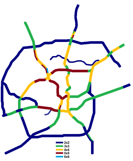
Below are some basic statistics about San Antonio's freeways. All statistics are from the Federal Highway Administration and cover the San Antonio Urbanized Area. The number in parenthesis is the San Antonio's rank nationally for that category for the top 100 urbanized areas.
- Centerline miles of freeway: 253 (23)
- Interstate highway miles: 177
- US and State highway freeway miles: 76
- Percent of local roads that are freeways: 3.10% (21)
- Lane miles of freeway: 1,419 (23)
- Lane miles per 1,000 people: 0.807 (17)
- Daily vehicle miles driven on freeways: 22,213,000 (21)
- Percent of total local daily traffic carried on freeways: 48.5% (11)
Freeway system layout
The city's freeway network was designed on the spoke-and-loop system. Eight radials, two loops, a spur, and a lateral parkway make up the system. The goal of the system's planners in the 1950s was that no Bexar County resident would be more than 30 minutes from downtown San Antonio. With today's traffic and overall growth of the city, the new rule is more like 30-45 minutes, but the spirit of that goal — a comprehensive controlled-access highway network — has been realized. San Antonio is a classic example of a city that would come to a grinding stop without its freeways. Many destinations require a freeway trip, including many short-distance journeys. Only a swath of the northwestern part of the city lacks relatively close freeway access, although it was planned at one time (see the "Unbuilt/cancelled freeways" section below).
Before the turn of the century, most of the city's busy freeway segments outside downtown were just six lanes, but over the past couple of decades, many of them have been expanded to eight and 10 lanes. In 2005, about nine miles of freeway were 10 lanes; today, there are roughly 30 miles, with more under construction.
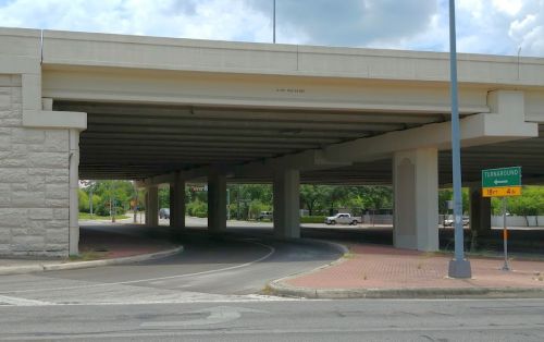
Access roads & turnarounds
Texas uses frontage roads extensively, and San Antonio is no exception. Locally, they're traditionally referred to as "access roads." Only about one-fourth of the freeways here don't have access roads. These include sizable sections of I‑10 East, I‑37 South, US 281 North between downtown and Loop 410, and about half of US 90 West. The downtown freeways also lack access roads. In these areas, interchange types seen in the rest of the world are used.
Dedicated U‑turn lanes are usually provided at intersections to allow traffic to turn-around and head the opposite direction on the opposite frontage road without having to traverse the signalized intersection. In San Antonio, these are known as "turnarounds" and generally signed as such.
For more information on frontage roads and turnarounds, see my Texas Highways primer.
Median barriers and fencing
Median barriers in Texas have shifted away from conventional Jersey Barrier (sometimes called "K-rails") to Constant Slope Barriers. All new projects in the San Antonio area since the early '90s have featured the newer type of barrier.
Fencing/glare screens atop the median barriers used to be universal on area freeways. Due to increasing maintenance costs, median barrier fencing was phased-out from new projects starting in the late '80s, and damaged sections were not replaced. Fifteen miles of fencing was removed in 1996 on Loop 410 to accommodate conduit for TransGuide fiber optic cable atop the center barrier, and the fencing was removed from all of the other local freeways circa 2000. Short sections have been re-installed in areas where there have been problems with pedestrians crossing the freeway.
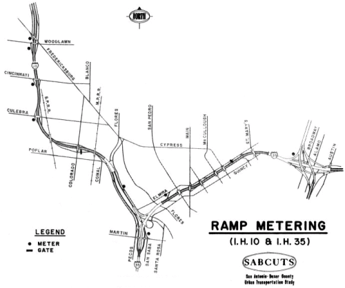
Ramp metering
Like median barrier fencing, ramp meter signals are now a thing of the past in San Antonio. The first ramp control signal was installed in May 1973 on the entrance ramp from Culebra to eastbound I‑10. By 1980, there were nine locations equipped with meter signals. All but one of these were in the downtown area along I‑10 or I‑35. The exception was the southbound US 281 entrance ramp from eastbound Basse. San Antonio even had a rarity in ramp metering: a meter signal on a freeway-to-freeway ramp, specifically the southbound US 281 ramp to southbound I‑35.
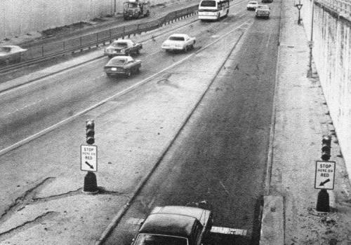
In addition to the meter signals, there were also two entrance ramp gates — one on the entrance ramp from Colorado to eastbound I‑10, and one on the entrance from St. Mary's to southbound I‑35 (both of these ramps no longer exist). These gates were used to close the entrance ramps during the morning rush hour to help reduce congestion caused by traffic influx and weaving problems associated with the proximities of those entrances to other ramps.
The "Downtown Y" double-decking project (see next topic below) during the '80s removed all of the signals and gates along I‑10 and I‑35. For a long while, the ramp meter on the Basse entrance ramp to US 281 was the last one remaining in the city, although it was rarely — if ever — used. It was upgraded in early 2005 with new equipment and tested for a while, but subsequently removed entirely in June 2005.
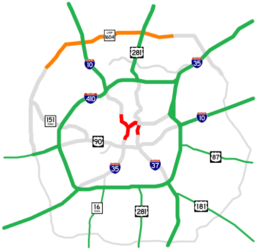
Double-decked freeways
Roughly eight miles of I‑10 and I‑35 around downtown San Antonio are double-decked. These seminal local freeways were rebuilt and double-decked in the $272 million "Downtown Y" project from 1983 to 1994. Named for the "Y" formed by I‑10 and I‑35 west of downtown, the project improved 10 miles of the four-lane freeway system built in the late '40s and early '50s. Besides being obsolete, those freeways had suffered from chronic congestion almost since they had opened. Earlier proposals to relieve the congestion there by constructing a bypass route on the near West Side were eventually scuttled (more on that in the "Unbuilt/cancelled freeways" section below).
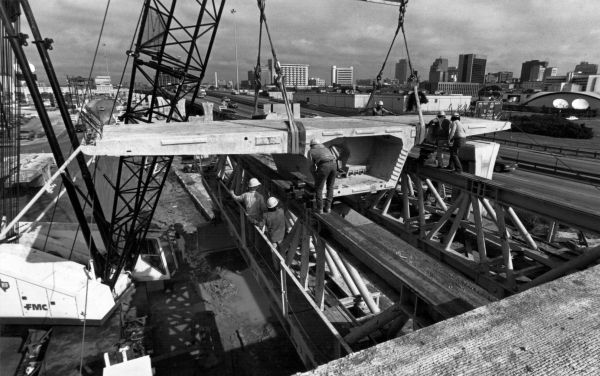
About six miles of the original freeway was located below grade and in a narrow right-of-way that made a conventional widening prohibitively expensive. The double-decking added elevated structures on a single row of piers located just to the outside of the original freeway but within the existing right-of-way. This allowed the upper level to overhang the lower level, thus allowing the additional lanes to be shoehorned into the original right-of-way and without the extensive excavation that would have been required to expand the existing highway at-grade.
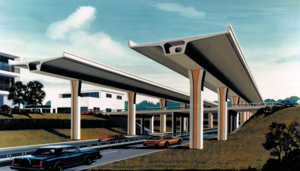
The elevated structures were built using a then-new type of construction called "segmental winged-T" bridges. Besides being aesthetically-pleasing, this method had the major technical benefit of allowing the bridge segments to be cast off-site and then trucked in and assembled in-place, thus expediting construction and minimizing traffic disruption. Segments were lifted onto a special support truss and joined together with epoxy. Then tensioned cables called tendons located within ducts inside the segments were tightened to hold the structure together. It was likened to a suspension bridge but with the cables inside the bridge.
An observant motorist driving on the lower levels may notice a difference in the piers used on each side of the road. The original design was modified midway through the project to allow for improvements to the bridge segments that made the casting process easier and reduced costs. This new design increased the width of the bridge "spines" and, thus, required a wider pier to support it.
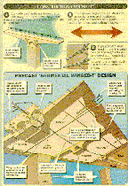
In 1995, a section of the upper level of I‑10 near Fredericksburg Rd. was closed when cracks were discovered in a couple of support piers and segments. A temporary support, similar to the ones used to support damaged bridges after an earthquake (which, coincidentally, occurred in the area a few days later) was installed, and the upper level — except for the Fredericksburg Rd. entrance ramp — was reopened. That entrance ramp, as well as the main upper level section, were eventually reinforced with strategic steel rods. Other than this, the design has fared well, and the double-decked roads have provided much needed capacity to the downtown area freeway network. For a diagram on how the upper levels were built, click on the image below.
In 2024, with the double-deck structures now 30 years old, a program to replace the bridge joints and perform other required major maintenance was started.
Speed limits
Prior to 1987, the national speed limit was 55 mph, and all freeways in San Antonio were posted at 55 mph with the downtown freeways posted at 50. In 1987, the federal government permitted states to increase the speed limit to 65 mph on rural Interstates. In San Antonio, this applied to I‑10 West north of Loop 1604 and to the other Interstates outside Loop 410 with the exception of I‑35 North, which was posted at 55 mph all the way to FM 306 north of New Braunfels. The national speed limit was completely repealed in 1995.
Today, most freeways inside of Loop 410 are posted at 60 or 65 mph. Outside of 410, speed limits are generally 65 on the North Side and 70 on the South Side. Speed limits jump up to 70 outside of Loop 1604 on the North Side except on US 281, which is 60 and 65. Loop 410 is 65 mph north of US 90 and 70 mph to the south. Loop 1604 is generally 70 mph on its freeway segments with some 65 and 55 stretches in Live Oak and Universal City.
While the City of San Antonio still has an ordinance declaring that the minimum speed limit on freeways is 10 mph below the posted maximum speed limit, minimum speed limit signs were removed during the mid and late '90s.
Left lane truck restriction
 In 2004, the San Antonio City Council passed an ordinance prohibiting trucks from using the left lane of US 90 (both East and West) inside Loop 410 between 6 am and 9 pm Monday through Friday. This was a trial project to determine whether similar restrictions should be implemented on other area freeways. A before-and-after study showed an overall 10% reduction in crashes along the corridor with a 30% reduction in crashes involving trucks. However, the restriction has not been expanded to any other freeways within the city of San Antonio.
In February 2007, the Texas Transportation Commission extended the existing left lane truck restriction in place along I‑35 in the Austin area south from San Marcos to just inside Loop 1604. A continuation of that restriction on I‑35 through the city of San Antonio was subsequently investigated but no action ever taken.
Signage
Signage on local freeways is generally good. However, Interchange Sequence Series signs (the signs that list the next three exits), which are used widely in many urban areas, are only used sporadically here.
Diagrammatic signage also used to be virtually non-existent locally, but is now being widely deployed near interchanges.
Another peculiarity are control cities, or specifically the lack of consistency regarding inbound control cities vis-à-vis downtown. On I‑35 and US 281, pull-through signs switch the inbound control city from "San Antonio" to "Downtown San Antonio" at about Loop 410. But on US 90 West and I‑37 South, signs inside Loop 410 use "San Antonio". On I‑10 East, the signs read "San Antonio/El Paso", and I‑10 West has several signs inside and outside of Loop 410 reading "San Antonio/Houston" even though signs approaching Loop 410 read "Downtown San Antonio" (and one that just reads "Downtown".) Meanwhile, even when the control city on the radial freeway is "Downtown San Antonio", guide signs on the corresponding Loop 410 ramps at the same interchange just show "San Antonio".
Unbuilt/cancelled freeways
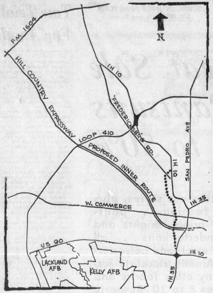
The only major freeway that was consistently listed in various plans over the years but was never built was the Bandera Expressway, sometimes also called the Hill Country Expressway. This route would have filled what is now an obvious missing link in the system. Two corridors were proposed over the years for this freeway. The first, proposed in 1964, would have started on Bandera Rd. outside Loop 410 and paralleled Bandera to the west southward to Guadalupe St. before turning east, crossing I‑35, and roughly following today's Cesar Chavez Blvd. to I‑37, then heading northeast to end at Commerce St. east of downtown (click here for a map). Although the linked map shows it starting at Loop 410, other documents indicated it was planned to start in the Huebner Rd. area. Eventually, the plans took it past Helotes to serve the planned San Antonio Ranch "new town" development.
The second route, proposed around 1971 in response to growing opposition (more on that below), would have run along Culebra from I‑10 to Loop 410 (click here for a map). The proposed route was subsequently extended to Loop 1604.
These plans came at a time when "freeway revolts" were part of the national zeitgeist and on the tail end of the local brouhaha over the construction of the McAllister Freeway (US 281), and a groundswell of opposition arose due to the projected displacement of thousands of West Side residents and businesses — especially in the so-called "Model Cities" area on the near West Side, created under the LBJ administration's "War on Poverty" program. A couple of budding politicians of the time named Henry Cisneros and Henry B. Gonzalez led the opposition. The project was revised several times in an effort to make it more palatable, including the Culebra routing, as well as to include busways and enhanced transit in the corridor, and even to downgrade it from a freeway to an "avenida" boulevard. (If you've been following the recent Bandera Rd. proposals in Leon Valley, this will sound strikingly familiar.) But the project was ultimately cancelled when the San Antonio City Council withdrew its support for it.
Hand-in-hand with the Bandera Expressway, a bypass route for I‑10 downtown was proposed several times in the '50s, '60s, and '70s to relieve congestion along the original "Downtown Y" expressways of I‑10 and I‑35. The first proposal would have routed this bypass down the Navidad Street corridor from I‑10 at Fulton to US 90 near Zarzamora. Subsequent plans had it running further east, first along or near Brazos Street, then following the railroad right-of-way. This bypass was scrapped along with the Bandera Expressway in the mid '70s and a new plan to double-deck I‑10 replaced it.
Two small connector freeways branching from US 281 were also proposed in 1964. One would have connected US 281 with I‑35 roughly along St. Mary's St. The other would have upgraded San Pedro between Loop 410 and US 281 to a short connector freeway. It's unclear why these never came to fruition.
Finally, a freeway along Roosevelt Ave., which at the time was US 281, was briefly proposed in the mid '50s.
For more information on the history of the freeway system and proposed routes, see the history page.
Looking at maps and seeing the way it was built, State Highway 16 South and Spur 422, which branches off of I‑35 in southwest San Antonio, was likely intended to eventually be a freeway. In fact, the road is officially named the Poteet-Jourdanton Freeway. Strictly technically-speaking, though, it should be named the Poteet-Jourdanton Expressway (or maybe even better, the Poteet-Jourdanton Highway) as the road is a four-lane divided highway with signalized intersections but with frontage roads along several miles. This configuration would have allowed the roadway to be upgraded to a freeway relatively easily by simply building overpasses for the mainlanes at the major intersections. Additionally, the interchange at I‑35 used to have direct ramps from I‑35 to Spur 422; those ramps were removed circa 2010. When the road was built, projections saw the city expanding to the south. Instead, San Antonio has grown mostly northward and westward. As a result, the relatively lightly-used Spur 422 remains mostly in its original configuration.
Metropolitan Planning Organization
The Alamo Area Metropolitan Planning Organization (AAMPO) is an agency created in accordance with federal law to coordinate and distribute state and federal transportation funding for the San Antonio area. This area originally included Bexar County and parts of neighboring Comal and Guadalupe County. In 2013, it was expanded to include all of Comal and Guadalupe counties as well as southern Kendall County around Boerne. In 2024, it was expanded to all of Kendall County, the eastern half of Medina County, and a tiny corner of northwestern Atascosa County.
AAMPO was previously named the "San Antonio-Bexar County Metropolitan Planning Organization" and, prior to that, the "San Antonio-Bexar County Urban Transportation Study" (SABCUTS), which was first established in 1963.
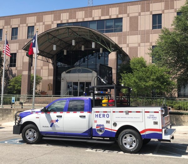
HERO/Courtesy Patrol
The Texas Highway Department started the Freeway Courtesy Patrol in San Antonio in 1968 during HemisFair to assist the large volume of visitors coming to the city for the fair. The patrol would help stranded motorists by providing gasoline, water, jump starts, tire changes or air, and assistance in making minor roadside mechanical repairs or arranging towing for vehicles that could not be repaired.
Although it was deemed very successful, the patrol was discontinued after HemisFair due to budgetary issues. A decade later, the program was reinstated with the added duties of clearing disabled vehicles, minor crashes, and debris from the roadways, assisting with traffic control at accident scenes, and placing temporary traffic control devices where needed. Budget issues again caused the program to be discontinued around 2008.
In 2018, TxDOT obtained funding to restart the local program once more, and the patrol hit the roadways again on August 31, 2020. The Highway Emergency Response Operation (HERO) program covers about 240 miles of local freeways with 28 vehicles. The HERO patrol will provide all the aforementioned services with full coverage operating weekdays from 5 am to 9 pm and limited service at other times. Assistance is free and can be requested by calling 210-732-HERO.
During its first 18 months in operation, HERO assisted with over 64,000 incidents, or an average of about one incident every 12 minutes, and provided over 127,000 services to motorists. A Texas Transportation Institute study in 2021 estimated that the HERO program reduced secondary crashes at incident scenes by nearly half.
Traffic congestion
Because of the extensive network of freeways, studies show that San Antonio typically suffers lower levels of overall congestion compared to other large cities, although it has increased substantially in recent years. On average, the freeway and arterial street systems are operating slightly over capacity. However, most of the area's freeways now have sections that suffer moderate to severe daily congestion. Expansion work is underway or planned for many of these roads.
Rush hours are generally from 6-9 am, and 3-7 pm.
Hazardous materials route
 At one time, San Antonio was the largest metropolitan area in Texas with no hazardous cargo routing plan. However, after a series of hazmat accidents near downtown in the mid '90s, a plan was finally drafted around the turn of the century and was approved by the state in June 2001.
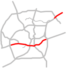
The map below shows the adopted hazmat routing plan. Designated hazmat routes are marked with the standard "HM" sign such as shown above.
The "Ice Plan"
The San Antonio area gets winter precipitation only a couple of times a year on average, usually in the form of freezing rain or sleet. Such precipitation, of course, makes driving very hazardous, especially on the numerous overpasses and flyovers. As a result, TxDOT and the San Antonio Police Department have formulated a plan to manage the city's freeway system during such events. The plan calls for TxDOT to begin de-icing bridges and overpasses using brine solution, chemical agents, and sand or chat rock when such precipitation begins or is predicted. If conditions become too dangerous, the plan calls for most of the freeway system to be shut down, mostly in areas with many overpasses or elevated lanes. Traffic is then routed to the access roads until conditions improve.