|
||
|
|
||
This page last updated June 13, 2026 |


|
Portions of this project are currently in design The descriptions below are based on preliminary schematics and, as a result, details may change before the project goes to construction. The first two projects of this program are being built using a design-build contract, so final plans were not available before construction started as they typically are with a conventional bid contract. However, based on TxDOT's specifications and approved schematics, the ultimate design isn't expected to differ substantially from what is described below. |
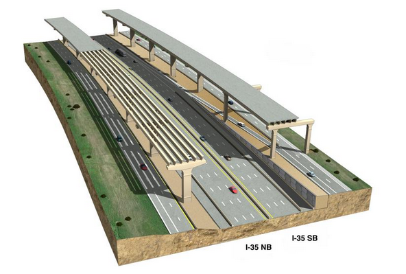
 TxDOT has been studying an expansion of I‑35 from downtown San Antonio to the Schertz area since the mid '90s. For much of that time, those plans necessarily included tolled lanes due to the project's cost and funding constraints. But with increased funding for state highways and the deprecation of tolling, the toll component of this expansion has been removed, and TxDOT is now planning to expand I‑35 by adding non-tolled express lanes and HOV lanes from Frost Bank Center Dr. to FM 1103. The new lanes will be elevated (double-decked) south of FM 3009 and be at-grade from there to FM 1103.
Below is complete information about this project and the latest status.
|
ADVERTISEMENT |
On this page:
Background
In 1996, a Major Investment Study of the I‑35 northeast corridor recommended barrier-separated express lanes as the best long-term solution for the corridor. However, acute funding shortages in the early 2000s caused this plan to be shelved.
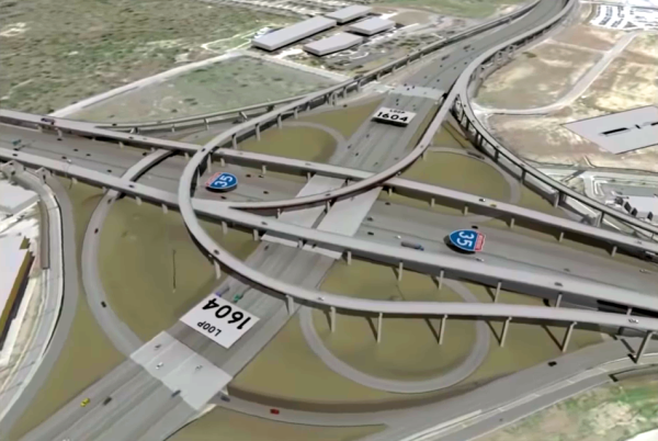
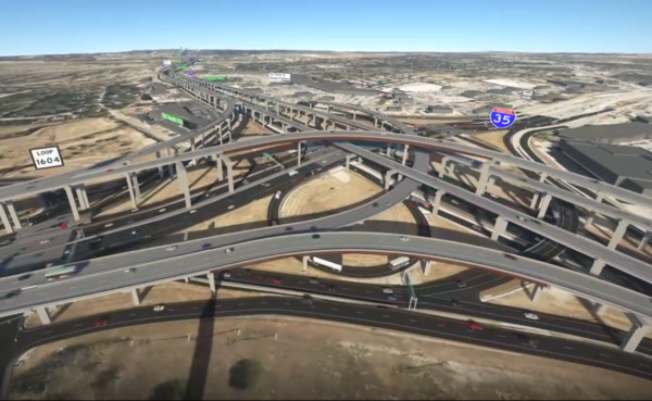
In 2009, the Alamo Area Regional Mobility Authority (ARMA) included this corridor as a secondary phase for a local tollway system and initiated a Planning and Environmental Linkages (PEL) study in 2011, which essentially reiterated the findings of the 1996 study. The subsequent in-depth study proposed two express lanes in each direction with connectors to Loop 1604, Loop 410 Northeast, and Loop 410 South. As the plans were further fleshed-out, it was determined that the new lanes would have to be elevated along most of the route from downtown to the FM 3009 area due to right-of-way constraints. The environmental study for that project was completed and approved in 2015.
Around that time, tolling became deprecated both locally and statewide as the legislature and voters approved new funding sources for highways. As a result, the various local planned toll projects were successively "de-tolled" as new funding sources were identified for them. Tolls were removed from the I‑35 project in June 2018.
With the toll component removed, TxDOT began work redesigning the project without tolls. Additionally, recent local transportation policy changes have promoted the addition of HOV lanes to freeway expansion projects where feasible. Given the length and commuting patterns of this corridor, as well as an already impressive 10% carpooling rate, HOV lanes were determined to be a good fit and therefore were added to the project.
Project description
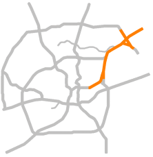
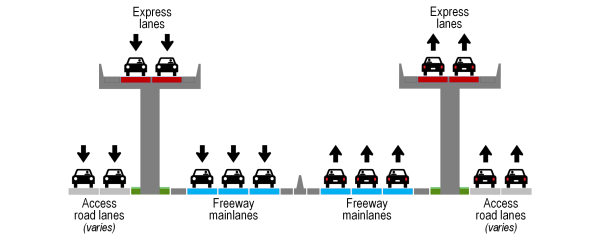
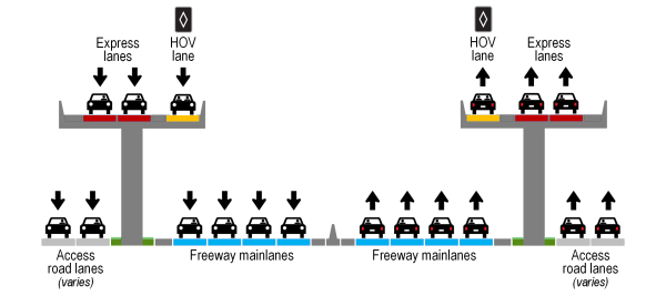
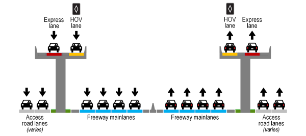
This $3.2 billion project will add non-tolled express lanes and HOV lanes on about 19 miles of I‑35 from Frost Bank Center Dr. to FM 1103. The new lanes will be elevated (double-decked) south of FM 3009 and will be at-grade from there to FM 1103. There will be two express lanes in each direction from Frost Bank Center Dr. to Rittiman Rd., two express lanes plus an HOV lane in each direction from Rittiman Rd. to the Bexar county line, one express lane and one HOV lane in each direction from the county line to FM 3009, and one new at-grade general-purpose mainlane and one HOV lane in each direction from FM 3009 to FM 1103.
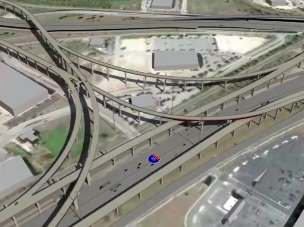
The project will also build new interchanges above or near the existing interchanges to connect the new upper level lanes to Loop 410 South, Loop 410 Northeast, Loop 1604, and Pat Booker Rd., as well as an intermediate access point to and from the I‑35 mainlanes at the Bexar county line, and make some incidental changes to existing roadways to accommodate the new elevated lanes and interchange ramps. The new interchanges will serve the upper levels only; the existing interchanges at those locations will remain as they are and will continue to serve what will become the lower-level lanes of I‑35.
Cross-section from Frost Bank Center Dr. to Rittiman Rd.
Cross-section from Rittiman Rd. to Bexar county line
Cross section from Bexar county line to FM 3009
Cross section from FM 3009 to FM 1103
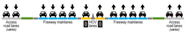
NOTE: In the cross-sections above, the number of access road lanes varies depending on location. Diagrams are for illustrative purposes only and are not to scale.
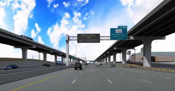
Unlike the double-decked freeways downtown, the upper levels on this project will be express lanes, meaning there will be limited entrances and exits along their length. The intent for the new lanes is to provide an express facility for longer-distance through traffic in the corridor, but this will also benefit the lower-level by removing much of that long distance traffic from those lanes.
In addition to the north end (FM 3009 area) and south end (Frost Bank Center Dr. area), motorists will also be able to enter or leave the elevated lanes at the following locations:
- Bexar county line:
- Southbound entrance from I‑35 mainlanes to elevated lanes
- Northbound exit from elevated lanes to I‑35 mainlanes
- Loop 1604
- Connectors to/from Loop 1604 (initially only to/from west of I‑35)
- Pat Booker Rd.:
- Entrance from Pat Booker to southbound elevated lanes
- Exit from northbound elevated lanes to Pat Booker
- The access ramps will be located on Pat Booker between I‑35 and Loop 1604
- Loop 410 Northeast:
- Connectors to/from northbound and southbound elevated lanes, connecting to Loop 410 near Perrin-Beitel Rd.
- Loop 410 South:
- Connector from northbound Loop 410 to northbound elevated lanes north of FM 78
- Connector from southbound elevated lanes to Loop 410 southbound north of FM 78
- Southbound exit from elevated lanes to I‑35 southbound access road south of Rittiman Rd. (i.e. BAMC exit)
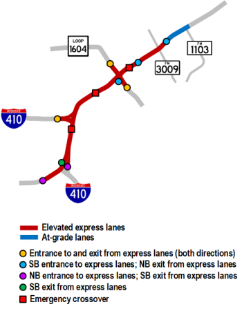
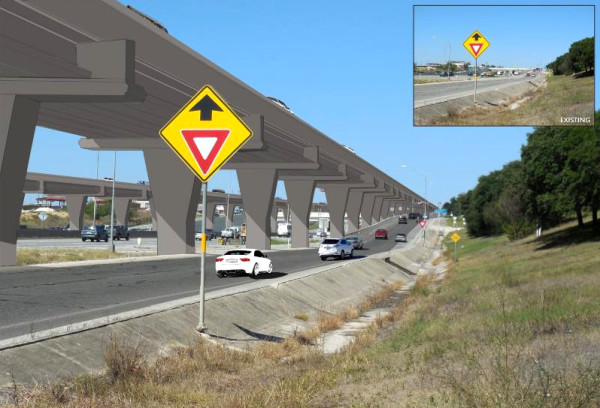
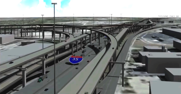
Crossovers between the two upper levels will be provided for emergency access at three locations in the corridor: between Eisenhauer Rd. and Walzem Rd., near O'Connor Rd., and near Olympia Pkwy. (see rendering below.)
The project will also include several ramp revisions and other minor adjustments to existing roadways to accommodate the access and egress locations and columns for the new elevated lanes. Turnarounds will be added at Schertz Pkwy., Cibolo Valley Dr., and at FM 2252, and new overpasses and intersection improvements will be also included at Cibolo Valley Dr. and FM 2252.
Timeline
Current funding constraints, as well as engineering and contracting considerations, require the project to be divided into multiple phases. Initially, funding was only available for the Central Segment from Loop 410 Northeast to FM 3009, including the new connectors to Loop 410 Northeast and to Loop 1604 to the west of I‑35. In August 2019, the Texas Transportation Commission approved additional funding for half of the South Segment stretching from Loop 410 South to Loop 410 Northeast, and work began in September 2023. Another section of the South Segment, on Loop 410 at FM 78, started construction in mid 2025. The remaining section of the South Segment, from Walters St. to Loop 410 South, started construction in early 2026. The North Segment from FM 3009 to FM 1103 and the connectors for Pat Booker Rd. and for Loop 1604 east of I‑35 are funded in the state's 10-year plan and are exected to start construction in the next few years.
The Central Segment and South Segment 1 of this project are being built using a design-build contract, which means that TxDOT has selected a contractor who will complete the final design of the project, build it, and then maintain it for five years. This process generally results in time and cost savings due to the ability to overlap design and construction timelines, as well as increased efficiencies from a single entity managing the entire project. The remaining phases are currently anticipated to use the more traditional design-bid-build process, but that could change.
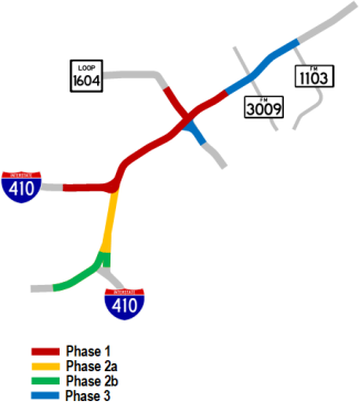
CENTRAL SEGMENT: Loop 410 Northeast to Bexar county line
- Status: Construction started in June 2022, 76% complete
- Timeline: Estimated completion in late 2027
- Cost: About $1.62 billion
This phase will include the following:
- Two elevated express lanes and one HOV lane in each direction
- Connectors from the elevated lanes to Loop 410 Northeast just south of the existing interchange except the southbound I‑35 to westbound Loop 410 connector, which will mirror the existing connector
- Connectors from the elevated lanes to Loop 1604 west of I‑35 (the NB to WB connector will be about 120' tall)
- Upper levels for this phase will end at the north at the intermediate access point at the Bexar county line, and at the south at the Loop 410 Northeast interchange
- Emergency crossovers for the elevated lanes near O'Connor Rd. and Olympia Pkwy.
- Additional lanes on Loop 410 Northeast to accommodate access to and from the new elevated lanes
- Ramp revisions on eastbound Loop 410 from Nacogdoches to Perrin-Beitel to accommodate the new interchange ramp and smooth traffic flow approaching it
- Ramp revisions and frontage road alignment adjustments at a few locations along I‑35 to accommodate elevated lane columns and ramps
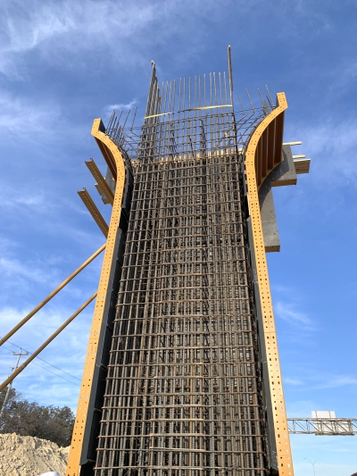
- This phase will require the construction of 800+ bridge spans consisting of 4,500 concrete beams, 900+ columns, and six million square feet of bridge decks
SOUTH SEGMENT PHASE 1: Loop 410 South to Loop 410 Northeast
- Status: Construction started in September 2023, 58% complete
- Timeline:Estimated completion in late 2028
- Cost: About $654 million
This phase will include the following:
- Two elevated express lanes in each direction from Petroleum Dr. to Rittiman Rd. This section will be "ghost" bridges when completed; i.e. they will not be used by traffic as they will dead-end in the air until they are extended to the south in a later phase.
- Connectors from the elevated lanes to Loop 410 South, dropping down to Loop 410 between I‑35 and FM 78
- Two elevated express lanes and one HOV lane in each direction from Rittiman Rd. to Loop 410 Northeast
- Southbound elevated lanes exit to I‑35 access road north of George Beach Ave.
- Ramp revisions on southbound I‑35 between Rittiman Rd. and George Beach Ave.
- Emergency crossover for the elevated lanes between Eisenhauer Rd. and Walzem Rd.
SOUTH SEGMENT PHASE 2: Walters St. to Loop 410 South
- Status: Construction started in January 2026, 13% complete
- Timeline: Estimated completion in early 2030
- Cost: About $342 million
This phase will include the following:
- Two elevated express lanes in each direction from Frost Bank Center Dr. to Petroleum Dr. where they will connect with the section previously built in Phase 2a
- Widening of I‑35 and ramp revisions between Walters St. and Frost Bank Center Dr. to accommodate approaches to and egress from elevated lanes
SOUTH SEGMENT PHASE 3: Loop 410 South from I-35 to FM 78
- Status: Construction started in March 2025, 42% complete
- Timeline: Estimated completion in late 2028
- Cost: About $85 million
This phase will include the following:
- Reconstruction and widening of Loop 410 bridges over FM 78, construction of a southbound Loop 410 access road over FM 78, and ramp relocations
- (A future phase of the I-10/Loop 410 interchange project will build a northbound access road bridge over FM 78.)
NORTH SEGMENT: Bexar county line to north of FM 1103.; Pat Booker Rd./Loop 1604 East interchange
- Status: Funded
- Timeline: Tentatively planned for 2029
- Cost: About $528 million
This phase will include the following:
- One elevated express lane and one HOV lane in each direction from Bexar county line to FM 3009
- One additional mainlane and one HOV lane in each direction from FM 3009 to FM 1103
- Widened overpasses at Cibolo Valley Dr. and at FM 2252
- Ramp revisions between FM 3009 and FM 1103
- New turnarounds at Schertz Pkwy., Cibolo Valley Dr., and FM 2252
- Connectors from the elevated lanes to Loop 1604 east of I‑35
- Connectors from the elevated lanes to Pat Booker Rd.
- Changes to Pat Booker Rd. between Loop 1604 and I‑35 to accommodate the new connectors
|
ADVERTISEMENT |
How this project will help
This corridor experiences frequently-recurring congestion due to traffic volumes regularly exceeding the capacity of the road. Studies of the corridor in the 1990s and early 2010s determined that a significant percentage of the traffic is passing all the way through the corridor or is traveling between the major interchanges and, therefore, recommended barrier-separated express to segregate that traffic — including a substantial amount of truck traffic — from the local traffic that will remain in the existing mainlanes, thus reducing congestion there.
It is estimated that when the Central Segment is complete, travel time on the existing mainlanes between the Bexar county line and Loop 410 North will be cut in half from about 20 minutes to less than 10 minutes. When the entire project is complete, the travel time between FM 1103 and Frost Bank Center Dr. is estimated to be reduced from about 45 minutes to less than 20 minutes.
HOV lanes are now being added to major freeway expansion projects in San Antonio where feasible. The intent is to encourage carpooling and use of mass transit. Each person that opts to do so is one less vehicle on the freeway, which helps to reduce congestion and pollution for everyone. A study of this corridor showed an impressive 10% of commuters were already carpooling, a number that could increase with the provision of an HOV lane. For more information about local HOV lanes, see the HOV lanes page.
Schematics and renderings
Click on one of the letters on the map below to open the detailed schematics for that section of the project. The base schematics are from TxDOT with my own annotations added to help clarify and explain the various elements. Each schematic will open in a new window that you can scroll and zoom.
The base schematic is the one presented to the public in August 2019. Some changes have been made since then and I've patched them over the base schematic; you may notice some slight misalignments and color differences in those locations.
On the schematic, any elevated segments colored in blue are the Central Segment (called the "base" sections in the legend). The sections colored in green south of Loop 410 NE (schematics C and D) are the South Segment. The sections colored in green north of the Bexar county line and east of I‑35 at Loop 1604/Pat Booker Rd. (schematics A and B) are the North Segment. (See phasing details above.) Other improvements shown in different colors will typically be done in the corresponding phase of the adjacent elevated section.
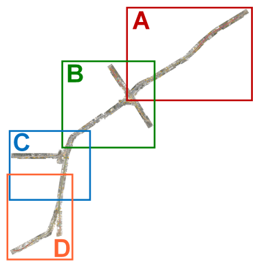
Click on one of the letters on the image above to open the detailed schematic for that section
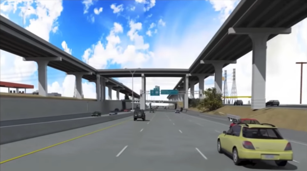
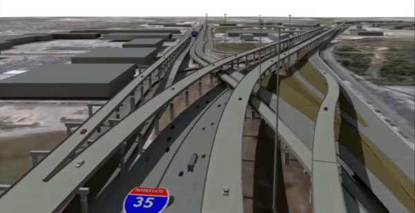
Below are several renderings of what the finished project might look like. Note that since this project is still in design, these are conceptual and the exact final project may vary from these. Renderings are framegrabs from TxDOT's I‑35 Expansion Video and I‑35 Northeast Expansion (NEX) Central Project video (Links in the "Other sites of interest" section below.)
Video
I put together a video overview of the NEX project including a virtual flyover of the Central Phase:
I‑35 NEX Preview
FAQ
- Will this project be tolled?
No. Although earlier versions of this project proposed adding managed toll lanes, funding was secured to remove the toll component. Instead, non-tolled express lanes and HOV lanes will be added. - Why are they building expensive elevated lanes instead of a more conventional at-grade widening?
The existing right-of-way along most of the corridor is inadequate for a traditional widening, and because of the extensive development along the frontage roads, the cost to acquire the needed right-of-way would be more expensive — and disruptive to the businesses and neighborhoods along the corridor — than building the elevated lanes. - Why aren't there more entrances and exits from the elevated lanes?
A study of the corridor in the 1990s determined that a significant percentage of the traffic is passing all the way through the corridor or is traveling between the major interchanges, a pattern that hasn't changed much today. Therefore, the intent of the new elevated lanes is to provide an express corridor for that traffic — including a lot of truck traffic — thus removing it from the existing mainlanes below. Since that traffic is traveling longer distances, they don't need those intermediate entrances and exits. Furthermore, additional entrance and exits would increase the traffic volumes on those elevated lanes and would also cause additional "friction" from entering/exiting traffic, both of which would engender congestion. Also, providing those additional entrances and exits would require additional right-of-way, which is limited in this corridor. This same concept (limited exits) is used on the I‑35 elevated lanes in Austin, the Katy Freeway express lanes in Houston, the Dan Ryan express lanes in Chicago, and the New Jersey Turnpike express lanes, among others. - The lack of entrances and exits will hinder emergency response and will trap traffic on the upper level if a crash blocks all the lanes.
To improve access for emergency vehicles and provide an escape route for trapped traffic, emergency crossovers will be constructed at three strategic locations in the corridor: between Eisenhauer Rd. and Walzem Rd., near O'Connor Rd., and near Olympia Pkwy. This same approach has been used on other long dual-span bridges that have limited or no access, most notably in Louisiana on I‑10 over the Atchafalaya Swamp and on the two bridges over Lake Pontchartrain. - I will not use/can't access the elevated lanes, so how will it benefit me?
Traffic that uses the elevated lanes will not be on the mainlanes below, so this will reduce traffic volumes and associated congestion there. It is estimated that when the first project is complete, peak period travel time on the existing mainlanes between the Bexar county line and Loop 410 North will be cut in half from about 20 minutes to less than 10 minutes. - Why are they not replacing the cloverleaf at Loop 1604 since they're replacing other cloverleafs around San Antonio?
That's a fair question. However, there are a few differences with this interchange. First, that eastbound Loop 1604 to northbound I‑35 "turbine" ramp helps to prevent the same kind of congestion seen in full cloverleafs since it removes the heaviest left-turn traffic from the weave area in the middle of the interchange. Second, it is expected that a substantial amount of traffic that uses the current interchange will instead use the new flyovers, which will keep it out of the cloverleaf. It's certainly possible that they'll need to replace the cloverleaf eventually, but for the foreseeable future, it should not see the same problems as other cloverleafs, and nothing they're doing now would prevent a future interchange replacement.
Other sites of interest
|
|
I‑35 NEX official project page https://www.i35nex.com |
|
|
YouTube - I‑35 Expansion Video (TxDOT) https://www.youtube.com/ |
|
|
YouTube - I‑35 Northeast Expansion (NEX) Central Project (TxDOT) https://www.youtube.com/ |