|
||
|
|
||
This page last updated January 29, 2026 |

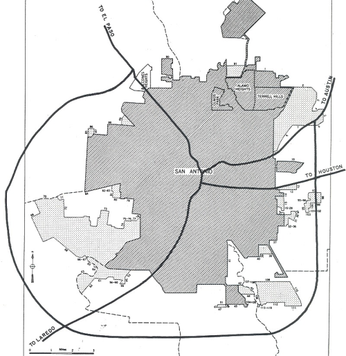
San Antonio's freeway system has been integral to the history of the city's growth, and San Antonio was at the forefront of the construction of urban freeways. After the first expressways opened downtown in the late '40s and early '50s, San Antonio went on an expressway-building spree, and for a while was second only to Los Angeles in the expanse of its freeway network.
Below is the best history of the San Antonio area freeway system that I can assemble. The information on this page was compiled from a wide variety of sources including old city maps, newspaper articles, and an array of highway plans, documents, and photos. Many thanks to the San Antonio Central Library Texana section and the San Antonio district office of TxDOT for their assistance in locating those materials.
This page covers the history of the expansion of the overall system, not capacity expansions or improvements on individual freeways — details of those are available on the individual freeway pages elsewhere on this site.
|
ADVERTISEMENT |
General freeway history
The convergence of US and state highways in downtown San Antonio, and the dramatic growth of automobile traffic in the 1930s, caused severe congestion in the central city. To address this growing problem, officials began planning a series of "interregional highways" in the late '30s to carry through traffic around downtown. However, the outbreak of World War II delayed this initiative. After the war ended, the effort resumed with a meeting of civic and business leaders in late 1946 where "the development of an interregional highway system in the San Antonio area" to help relieve increasing congestion on downtown streets was discussed. The manifestation of that was a 20-year master plan to ensure that San Antonio was at or near the front of the line to receive post-war state and federal funding to build an expressway system.
As a result, city maps from as early as the mid-1940s show a three-legged "Interstate Highways and Expressways for post-war construction" that is today's "Downtown Y" of Interstates 10 and 35. In plans and news reports, the routes were interchangeably referred to as expressways, urban expressways, freeways, or interregional, intrastate, or interstate highways.
That first master plan, and the accompanying civic and political support for it, helped San Antonio and Bexar County obtain voter approval for numerous bonds over the years to purchase right-of-way for the future expressways. It was this local cost-sharing that allowed San Antonio to leverage copious state and federal funds that propelled the construction of local expressways and landed San Antonio one of the Texas Highway Department's four dedicated Urban Expressways divisions (the others being Houston, Dallas, and Ft. Worth).
The expansion of the system got a massive boost in 1956, first with the state approval of a local expressway plan, and then with the launch of the Interstate Highway System, which designated San Antonio as the crossroads for two major Interstate routes. All of this meant that, just a decade later, Bexar County had nearly 180 miles of Interstates and expressways, a "metropolitan highway complex that...ranks second only to Los Angeles" according to a San Antonio Express and News report from 1966.
Beyond the Interstates, several other freeways were proposed over the years. Some were shelved due to cost or feasibility issues, and a couple died due to public opposition, but most were eventually built in one form or another, leading to the comprehensive system that is in place today.
Detailed history overview and notes
Below are maps and descriptions of the system (both completed and proposed) at various points since its inception at the end of World War II up to the current day. The years chosen were those for which I could find definitive information and/or were benchmark years in the development of the system. Between those dates, short-lived variations to specific plans may have been proposed but were not substantially different enough to warrant inclusion here.
In some cases, I found conflicting or incomplete information, so I had to extrapolate or infer the status of particular segments at certain times based on earlier and/or subsequent reports. This may result in some minor inconsistencies.
Early freeways here replaced existing US and state highways and initially carried those route numbers. It wasn't until the early to mid '60s that Interstate shields began appearing on local freeways. For reference, here is a list of the early highway designations, including the state highway designation that preceded the US route number, as well as the routing of those routes in 1945 just before the start of the first freeway project. Most of the routes were adjusted several times as the freeway system evolved and superseded them.
| TODAY | U.S. HWY | PRIOR DESIGNATION |
PRE-FREEWAY ROUTING |
 WEST |
Fredericksburg Rd., N. Flores St. | ||
EAST |
 |
E. Commerce St. | |
 NORTH |
 |
Broadway, Austin Hwy., Randolph Blvd. | |
SOUTH |
|
S. Alamo St., Nogalitos St., New Laredo Hwy. | |
 |
S. Presa St. | ||
WEST |
W. Commerce St., Old Hwy 90 W | ||
 NORTH |
San Pedro Ave. | ||
 |
N/A |
For Loop 1604, which was initially constructed as FM roads, those roads will also be shown as non-freeway roadways when they were built, and the various segments shown as completed freeway as they were upgraded to such in the following years.
Finally, a few segments of I‑35 on the far south and north sides of the county were initially opened as what I term "semi-freeways", which consisted of a full divided highway with access roads, but no overpasses at intersections (much like the current Poteet-Jourdanton Freeway on the South Side); the maps below will show these as completed freeway since they were celebrated — and more-or-less functioned — as such. They were upgraded to full freeways in subsequent years.
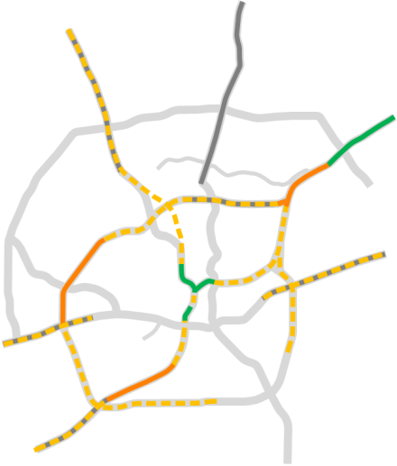
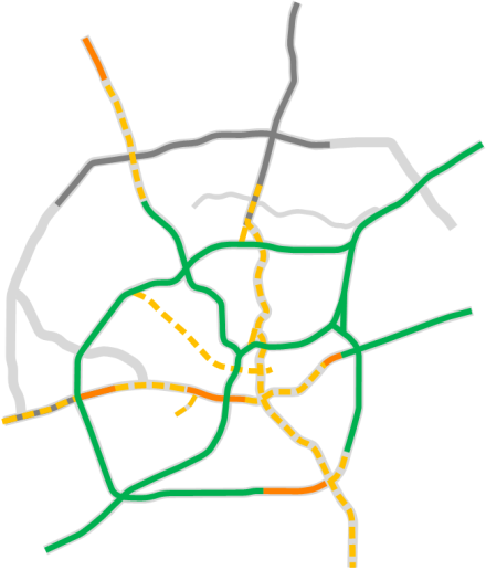
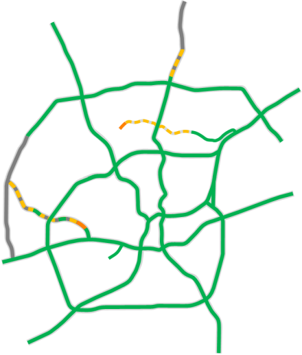
Pre-1949
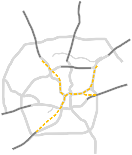

During the construction of San Antonio's freeway system, several existing sections of US and state highways in the outlying areas were upgraded to freeways. The maps on this page show those sections in dark gray as an "existing non-freeway roadway" until the time they're upgraded. (An explanation of how I designated the various pre-freeway roadways is just above this section.)
City maps from the mid-1940s show the earliest plans for an "Urban Expressway" network consisting of today's "Downtown Y" sections of I‑10 and I‑35 from Broadway to Nogalitos St. and out to Woodlawn Ave. Soon, extensions to that core system were proposed:
- The north extension (today's I‑10 West) was proposed to run north from Woodlawn Ave. to Fresno St., then northwest to meet Fredericksburg Rd. about ½ mile south of Huebner Rd.
- The south extension (today's I‑35 South) was proposed to follow Nogalitos St. from its intersection with present-day I‑35 southward to New Laredo Hwy., then south along that roadway; the planned southern terminus at that time is unclear.
- The east extension was proposed mostly along the path of today's I‑35 North out to the current interchange with Loop 410 near Windcrest, where it would merge into the existing Austin Highway (now Randolph Blvd.)
- A branch from the east extension at Frost Bank Center Dr. would head east along Gembler Rd. to meet the existing US 90 at today's Loop 410. (This branch would have been I‑10 East.)
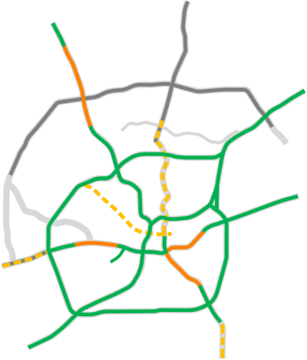
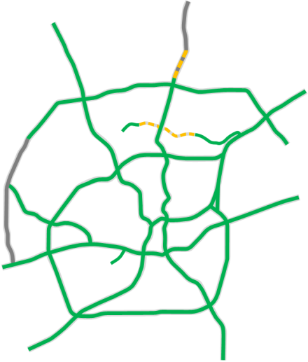
1949
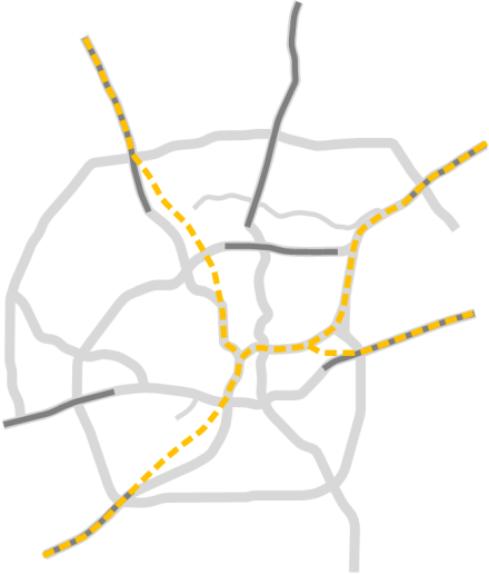
Construction of the city's first freeway — the US 87 Expressway (also today's I‑10) from Fredericksburg Rd. at Woodlawn Ave. to Comal St. (now Frio St.) — started in 1946. The first section was a 7⁄10th of a mile segment from Fredericksburg Rd. to Culebra Ave. that opened quietly and without fanfare on July 8, 1949. When the section from Culebra to Comal St. was completed a few months later, a ribbon-cutting ceremony was held on November 28th on the Colorado St. overpass to celebrate the official opening of the expressway. From Comal St., traffic used the existing Laredo St./Cameron St. boulevard along San Pedro Creek to reach downtown until the expressway was extended along that section to Martin St. in 1950.
Meanwhile, the plans for the southern extension had been adjusted to pass under Nogalitos St. and arc southwest to meet New Laredo Hwy. just north of Loop 13 (SW Military Dr.)
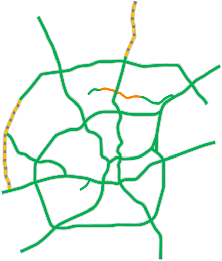
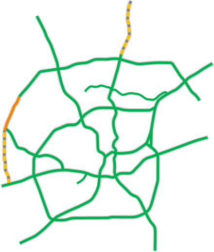
1952
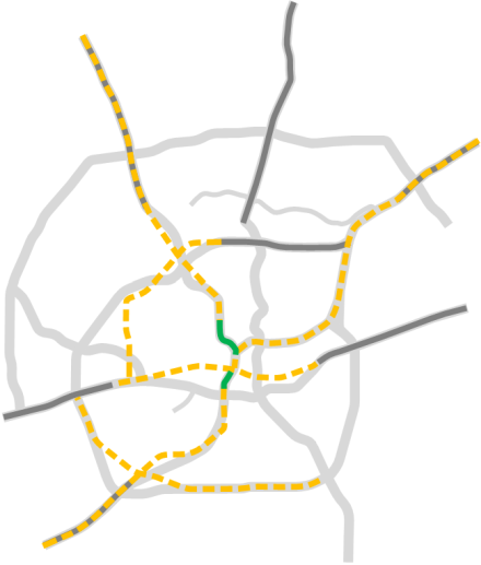
The first section of today's I‑35 South opened in late 1952 running from Guadalupe St. south to Nogalitos St. This left a short gap between the two expressway sections along the west side of downtown with the Pecos St./San Saba St. one-way pair connecting the two.
The proposal for today's I‑35 South had been adjusted again, this time to run due south from Nogalitos St. to near Southcross Blvd., then southwest from there to a point south of Military Dr. and west of Zarzamora St. (which was Aviation Rd. at the time), then west from there to join US 81/New Laredo Hwy. about ½ mile south of Pitlik Ave.
On the Northeast side, plans for the US 81 expressway would have extended it along Randolph Blvd. to Judson Rd. before continuing along today's I‑35 to the county line.
The city's 1951 master plan contained three plans for Loop 13. To complete the loop on the Northwest side, it proposed to route it west from its end at NW Military Hwy. to the intersection of Callaghan Rd. and Fredericksburg Rd. (Callaghan did not continue east of Fredericksburg at that time.) It then would have followed Callaghan Rd. southwest and south to end at US 90.
On the South Side, the existing Loop 13 along Military Dr. had become too busy to continue to be useful as a high-speed corridor, and it was hemmed-in by development that limited options to expand it. So the plan proposed to build a new bypass route a couple of miles south along Chavaneaux Rd. from Goliad Rd. west to Palo Alto Rd., then west-northwest to US 81 (New Laredo Hwy.), then northwest to Dwyer Rd. at Covel Rd. (this would be today's intersection of Loop 410 and Ray Ellison Dr.), then along Dwyer Rd. to end at US 90 west of Lackland AFB; much of this route eventually became the southern and southwestern sections of Loop 410.
Finally, on the Northeast Side, the existing Loop 13 on WW White Rd. was proposed to continue northward and follow the planned expressway to US 81 (today's Randolph Blvd.)
Although I have not found an official route map for it, I have discovered a few Highway Department aerial views and a map from this time with a hand-drawn proposed expressway route through the East Side, Southtown, and the West Side, as well as some artist's renderings showing a proposed US 90 expressway cutting through the middle of the King William District and a proposed interchange at I‑35 at El Paso St. These all appear to reveal a second proposed route for a US 90 expressway. Coming from the east, it appears the route would have used today's I‑10 and Commerce St. to just west of Salado Creek. From there, the route would have followed the Aransas Ave. corridor to near New Braunfels Ave. where it would have turned west and followed the Indiana St. corridor. After crossing today's I‑37, it would have turned northwest and crossed Presa St. and St. Mary's St. at Sadie St. Continuing northwest, it would have crossed Alamo St., the King William District, and the San Antonio River between Sheridan St. and Beauregard St. It then would have continued along Arsenal St. and El Paso St. to the aforementioned interchange with I‑35. (The map of proposed Interstate Highways near the top of this page also seems to confirm that this route was under consideration at this time.) West of there, it would have used the El Paso St./Guadalupe St.corridor straight out to Old Hwy 90, then followed that to current US 90 corridor and west from there.
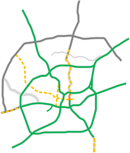
1955
The section of today's I‑35 around the north side of downtown from Martin St. to Broadway was completed in 1954. Also complete was the first major section of freeway outside of downtown: today's I‑35 from Toepperwein Rd. to the county line, including an interchange at Pat Booker Rd. Meanwhile, the routing south of there had been adjusted to bypass Randolph Blvd. and was starting construction, including an interchange for Austin Highway and Loop 13 (now Loop 410) to the west.
Plans for the southeastern segment of what would become Loop 410 and I‑37 were in limbo awaiting a decision on a possible runway expansion at Brooks AFB, but the alignment for the rest of Loop 410 had been finalized by this time, and construction on the first section of access roads running from US 90 to Marbach Rd. was underway as well as a two-lane stretch of roadway from there to Bandera Rd.
The alignment for I‑35 South had been adjusted yet again, this time to what would be its final alignment, and the access roads were now under construction from SW Military Dr. to the intersection with New Laredo Highway.
It appears the earlier proposal for an expressway through King William, Southtown, and the East Side had been scrapped by this time, leaving no plan for most of US 90 inside Loop 410. Despite it no longer being in the local plans, the alignment for I‑10 East in the 1955 "Yellow Book" of proposed Interstate routings still showed that earlier proposal (see the image near the top of this page).
By 1953, the alignment for I‑10 West been adjusted, this time running north-northwest generally along the railroad line before turning more northwesterly at West Ave. to intersect with Loop 410 at Vance-Jackson Rd., then continuing northwest to follow today's I‑10 alignment starting just south of Wurzbach Rd. By the middle of 1955, however, the ultimate routing between Woodlawn Ave. and De Zavala Rd. would be set. Interestingly, the "Yellow Book" route for I‑10 appears to follow Fredericksburg Rd., but I have found no local plans that show that route was ever considered. It's possible that may have been a "placeholder" routing using the existing US 87 alignment.
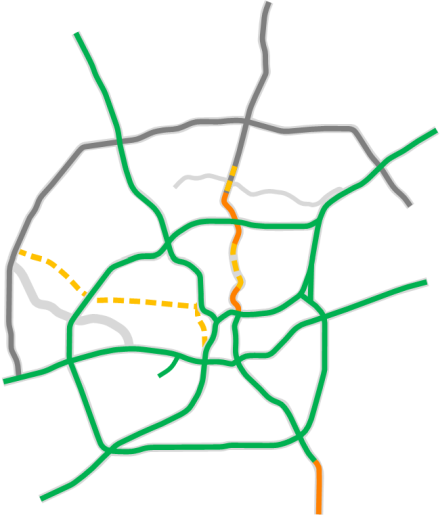
1957
The signing of the act creating the Interstate Highway System in 1956, which provided federal funding for 90% of construction costs, and strong public support resulted in local expressway planning reaching a fevered pitch by 1957. By this time, San Antonio was generally well ahead of other cities, with the San Antonio Express-News reporting that San Antonio was "outdoing all other Texas cities who, despite their boasting, have been unable to get an Expressway [sic] into their major business and shopping areas", and officials were hoping to continue the momentum with the release of an ambitious freeway plan in 1956.
The latest proposal for I‑10 West was for the alignment that would eventually be built. A new proposal for I‑10 east of I‑37 would have routed it along the Bailey Ave. corridor to Clark Ave. before turning northeast to meet Houston St. just east of Commerce St.
The first proposals for the eventual US 281 North and US 90 West expressways were now known, and the routing for the southeastern arc of Loop 410 had been settled. The eventual route for today's I‑37 inside Loop 410 was also on the books, but was still designated as US 181 and followed the US 181 corridor toward Floresville south of Loop 410. (I‑37 was not in the original Interstate system plan; it would not be designated until 1959.)
Several other freeways were proposed that eventually would be scrapped including a US 281 South freeway along Roosevelt Ave., the Bandera Expressway along Culebra Ave. and Bandera Rd. (it would go through several iterations before being abandoned), and the first proposal for an "inner bypass" west of downtown along Zarzamora St. to connect I‑10 West to I‑35 South. This bypass was planned to relieve congestion that had already manifested on the original sections of I‑10, and it also went through a few revisions before eventually getting scrapped in conjunction with the Bandera Expressway.
The access roads for I‑35 South from SW Military Dr. to New Laredo Hwy were complete, and the freeway was now being extended from Nogalitos St. south to Division Ave. A "semi-freeway", consisting of mainlanes and frontage roads but some at-grade intersections, was also complete from New Laredo Hwy. south to Loop 1604, as was the elevated "Central Expressway" along the west side of downtown which carried motorists "in the air through downtown" according to news reports at the time.
Work on the Fratt interchange (today's I‑35/Loop 410 NE/Austin Hwy./Randolph Blvd. interchange) was nearing completion, and I‑35 from there to Toepperwein Rd. was complete.
The section of today's Loop 410 (still Loop&npsb;13 at the time) from Marbach Rd. to Bandera Rd. opened in 1956 as a two-lane freeway (i.e. one lane in each direction), as did the access roads from Marbach Rd. to US 90. 1957 saw the opening of the Loop 410 mainlnes from Fredericksburg Rd. to Vance-Jackson Rd., and the access roads from there to San Pedro Ave.
The first proposal for an "Outer Loop" (now Loop 1604) was also included in the 1956 expressway plan. The route was originally expected to be designated Loop 26, then Loop 334, before the first sections were designated as FM 1604 in 1959.
Loop 1604 note: The overall Loop 1604 proposal is only shown during this year. It remained in the local highway plans from this point forward, but it was initially built as Farm-to-Market roads. For clarity, from this point on, "proposed freeway" sections for Loop 1604 will only be shown when plans were released to upgrade those original farm road sections to a freeway.
1959
The access roads for Loop 410 from Bandera Rd. to Babcock Rd., and the full freeway from Babcock Rd. to Fredericksburg Rd., were now complete. I‑35 South had been completed from Nogalitos St. to Division Ave. and was under construction between Division Ave. and SW Military Dr.
I‑35 North from Broadway to Rittiman Rd. was now under construction. I‑10 West was now under construction from Loop 410 northward to Fredericksburg Rd., and from Woodlawn Ave. to Fresno St. The southwest segment of Loop 410 between US 90 and Pearsall Rd. was complete, and was under construction from there to I‑35.
The final routings for I‑10 East inside Loop 410 and for I‑37 had finally been mapped, and I‑10 East from just inside Loop 410 eastward to FM 1516 had been completed.
The Bandera Expressway and inner bypass had been dropped from public plans, but were still on the Highway Department's drawing board. It appears the Roosevelt Ave. expressway had been cancelled by this point.
1961
Additional sections of freeway were now opening to traffic. The earlier sections of Loop 410 between US 90 and NW Military Dr. that were initially built as access roads and two-lane freeway had now been upgraded to a full freeway, and the section from Pearsall Rd. to I‑35 was complete. However, only the western arc of 410 from I‑10 West to I‑35 South carried the Interstate 410 shield; the section east of I‑10 was signed as State Loop 410 because it had not yet been designated as part of the national Interstate Highway system. (There reportedly was a disagreement between the state and federal highway authorities about design standards along that section that prevented an Interstate designation.) Loop 410 on the South Side between I‑35 and Roosevelt Ave. was under construction.
All of I‑35 South was now complete, and the previous section that had been built as access roads had now been upgraded to a full freeway.
I‑35 North from Frost Bank Center Dr. (then known as Artesia Rd.) to Rittiman Rd. was now open, while construction on the remaining sections between Broadway and Frost Bank Center Dr., and from Rittiman Rd. north to Loop 410, were nearing completion.
I‑10 West was now complete from Loop 410 northward to Fredericksburg Rd. and from Woodlawn Ave. to Fresno St., and was under construction from Fresno St. to Loop 410. The section of I‑10 East from FM 1516 eastward was also under construction.
Finally, the first section of the two-lane FM 1604 was complete between I‑10 West and US 281, followed shortly thereafter by the section from I‑10 to Bandera Rd.
1964
With federal Interstate Highway funding now pouring-in, and approval by city voters of expressway bond proposal, construction was continuing briskly.
By 1962, all of I‑35 in Bexar County was open, making I‑35 the first metropolitan Interstate in Texas to be fully completed. I‑10 West was now complete inside Loop 410 and was under construction from Leon Springs to Boerne. I‑10 East was complete east of WW White Rd. and was under construction from there to E Houston St.
Loop 410 on the South Side was open from I‑35 eastward to Roosevelt Ave. Most of the eastern arc from I‑35 southward to S WW White Rd. was complete, and the sections between San Pedro Ave. and I‑35 North had been upgraded to a full freeway by this time.
The first sections of US 90 West, from I‑35 to Cupples Rd. and Loop 410 to Pinn Rd., were just starting construction. An additional section of the two-lane FM 1604 from US 281 to Bulverde Rd. was complete.
New freeway routes were now on the drawing boards including Spur 371 (the "Kelly Access Freeway", now General Hudnell Dr.), and a resurrection of the previously-proposed Bandera Expressway with a routing that had it starting on the East Side near Commerce St. at Monument St., then crossing south of downtown generally along today's Cesar Chavez Blvd., then along El Paso St. to Zarzamora St., turning northwest to run mostly parallel to and just to the west of Bandera Rd. before supplanting Bandera Rd. between Evers Rd. and Loop 410 where it ended.
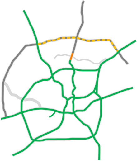
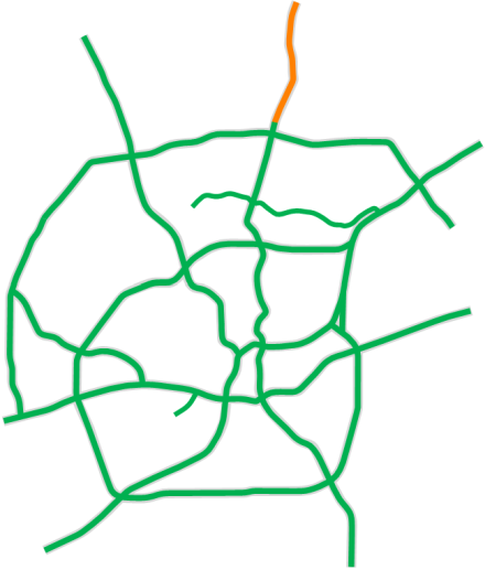
The routing of the North Expressway (US 281 North), which would soon erupt in a maelstrom of controversy, was now being fleshed-out. Two small freeway connectors were also planned for the North Expressway: one running north along San Pedro Ave. to connect Loop 410 to the new US 281 freeway, and the St. Mary's Connector, running parallel to St. Mary's St. and connecting US 281 to I‑35 just north of downtown. It would have also featured a downtown feeder spur in conjunction with elaborate distribution ramps for the other freeways surrounding downtown. (You can see those plans here.)
1967
Freeway construction continued to move forward full-steam in preparation for HemisFair in 1968. By 1967, the bulk of today's freeway system was either complete or under construction. All of Loop 410 was now done, but the section from I‑10 West to I‑35 North still carried the State Loop 410 designation; it would not see an Interstate 410 shield until mid-1969.
The first section of US 90 West from I‑35 to Cupples Rd. was open as well as the access roads between Loop 410 and Pinn Rd. I‑10 between I‑35 and I‑37 south of downtown was completed as was Spur 371 (General Hudnell Dr.) I‑37 was complete from US 181 to SE Military Dr. and from I‑10 to Florida St., and was under construction between I‑10 and SE Military Dr.
FM 1604 had been extended south from Bandera Rd. to Culebra Rd. and from Bulverde Rd. to Pat Booker Rd. I‑10 West from Leon Springs to Boerne and beyond was complete and was under construction between Leon Springs and Fredericksburg Rd.
Controversy was swirling around both the Bandera Expressway and the North Expressway, with the latter facing new challenges in the wake of a new federal law prohibiting the taking of parkland for highways as it traversed both Brackenridge Park and the Olmos Basin. The San Pedro Ave. and St. Mary's connectors for US 281 appear to have been scrapped by this time.
1969
When HemisFair opened in 1968, most of the city's freeway system was in place, both to serve travelers headed to the fair as well as an exhibit of the future in its own right. All of I‑10 and I‑35 were open. US 90 West was complete inside Loop 410, and I‑37 between I‑10 and SE Military Dr. had been opened. FM 1604 had been extended to US 90 West and to I‑10 East.
The section of I‑37's right-of-way next to the HemisFair grounds had been temporarily paved for use as a parking lot for the fair, but work started shortly after the fair closed to complete the freeway from Florida St. north to I‑35.
By this time, controversy was beginning to rage over the Bandera Expressway (also occasionally referred to as the "Hill Country Expressway"). A new alignment for the route west of Zarzamora St. had been proposed which had it veering west at 24th St. a few blocks north of Commerce St., then gradually turning northwest at Acme Rd. to cross Loop 410 near Culebra Rd. before more-or-less following Leon Creek to Bandera Rd., then along Bandera Rd. to Loop 1604.
Also making a renewed appearance in freeway plans in conjunction with the Bandera Expressway was the I‑10 bypass, which would run in the Navidad St. corridor from I‑10 near Fulton to US 90. A large interchange was planned where it would intersect the Bandera Expressway east of the Guadalupe/Zarzamora intersection. Both the Bandera Expressway and I‑10 bypass faced opposition due to the large number of homes and businesses that would be displaced as well as its possible impact on funding for the federal "Model Cities" urban renewal program area on the near West Side, which both expressways would bisect.
Meanwhile, progress was stalled on the North Expressway as the Highway Department negotiated with the federal government over its alignment.
1973
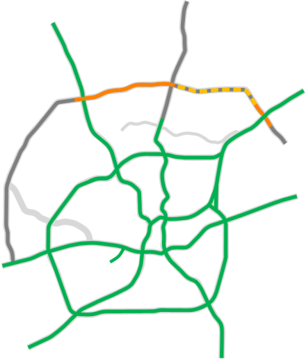
The battles over both the North Expressway and Bandera Expressway continued to rage on. On US 281, work on the undisputed northern and southern parts had been allowed to proceed in 1969, but was suspended in 1971 when the Conservation Society won a decision to revoke federal funding. In 1973, Congress passed a bill that allowed the state and city to complete the freeway without federal funding, and work resumed immediately.
Meanwhile, the previous Bandera Expressway route had been scrapped due to its path through the Model Cities area on the near West Side. A new proposal for the freeway, now officially being called the "Northwest Transportation Facility", routed it along Culebra Ave. from I‑10 to Loop 1604, skirting the Model Cities area to the north. In addition, a new route for the I‑10 bypass was proposed that shortened its length and took it closer to downtown following the railroad corridors, which also allowed it to skirt the Model Cities area to the east.
Amid the controversies, I‑37 had been completed downtown, and work had started to complete it from US 181 southward to the Loop 1604 area. FM 1604 had been extended south from US 90 all the way to SH 16 South.
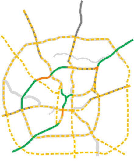
1979
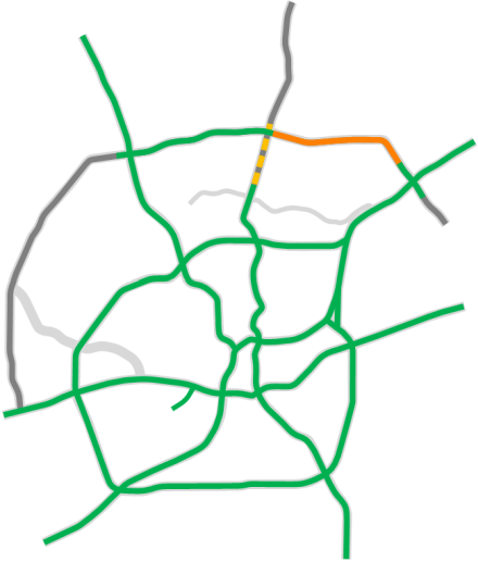
With the dismissal of the last lawsuit in 1974, the bitter war over the North Expressway was finally over, and most of the freeway opened in February 1978. The last section of the original plan, from Sandau Rd. to Bitters Rd., was nearing completion.
Opponents of the Bandera Expressway, however, won their fight, and the Bandera Expressway was cancelled along with the I‑10 bypass. Instead, planning was now underway to double-deck I‑10.
The last sections of FM 1604 south of the city were now under construction, and the road would soon be redesignated as Loop 1604. The increasingly busy and dangerous northern arc had become known as "The Death Loop", and planning to upgrade it to a freeway was now underway.
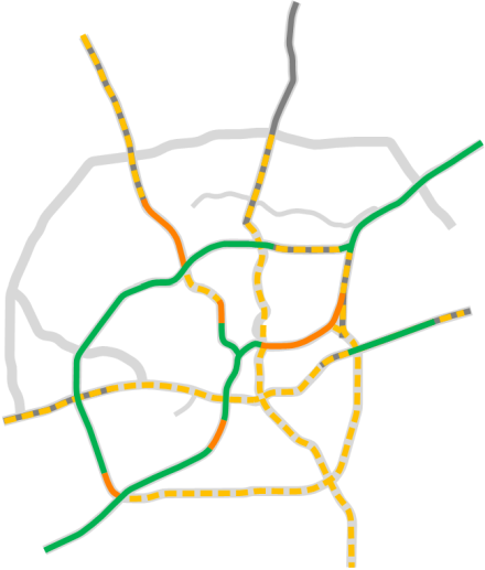
1984
By the mid '80s, suburban growth was beginning to reach the northern sections of Loop 1604, and an upgrade of the original two-lane farm road to a freeway was underway from I‑10 West to US 281 North as well as in the area around I‑35 North, and was planned between US 281 and I‑35.
1987
The expansion of Loop 1604 to a freeway from I‑10 to US 281 was complete as was the new Loop 1604/I‑35 North interchange, and work was progressing to upgrade 1604 between US 281 and I‑35. Plans to upgrade US 281 from Bitters Rd. to Loop 1604 were announced, and the access roads for a new freeway corridor — SH 151 — were under construction between Loop 410 and Loop 1604 (not indicated on map).
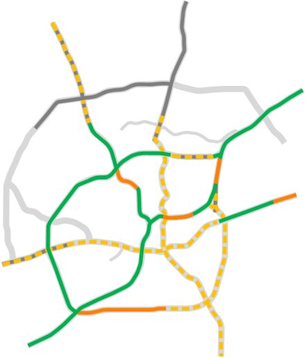
1990
The most heavily traveled sections of Loop 1604 across the North Side had now been upgraded to a freeway, ending the days of the "Death Loop", so-called because of the high number of fatal accidents that had occurred along it. Plans were now in the works to extend the western end of the freeway south to Bandera Rd.
Work to upgrade US 281 North between Bitters Rd. and Loop 1604 was completed in record time, and the SH 151 access roads were now complete along its entire route between US 90 and Loop 1604. Initial proposals had been announced for an "East-West Parkway" — subsequently named Wurzbach Parkway — to relieve traffic on Loops 410 and 1604.
2000
At the dawn of the new millennium, short sections of freeway mainlanes had been added to SH 151 at Potranco Rd., Pinn Rd., and Old Highway 90, and the freeway mainlanes from Old Highway 90 to Callaghan Rd. were under construction. Plans to finish the SH 151 freeway were now on the books.
An overpass on Loop 1604 at Kitty Hawk Rd. built in the mid '90s essentially extended that freeway east to FM 78. On the western end, Loop 1604 had been upgraded to a freeway from John Peace Blvd. to Bandera Rd.
The first section of the Wurzbach Parkway was open from Wetmore Rd. to O'Connor Rd., and the segment from Lockhill-Selma Rd. to NW Military Hwy. was nearing completion.
The first plans to upgrade US 281 from Loop 1604 to Stone Oak Pkwy. were announced. It would soon be embroiled in controversy like its predecessor to the south.
2005
Work to complete the mainlanes of SH 151 had been completed by 2005. Wurzbach Parkway was now open from Lockhill-Selma Rd. to Blanco Rd., and plans were on the books to finish the remaining segments.
Previous plans to expand US 281 from Loop 1604 to Stone Oak Pkwy. had been put on hold due to funding issues, and proposals to build it as a tollway created a firestorm of controversy that would delay it for over a decade.
2012
Work to finally build the missing middle segments of Wurzbach Parkway was now underway, and plans had been announced to extend the Loop 1604 freeway south from Bandera Rd. to US 90. Plans to expand US 281 north of Loop 1604 now extended all the way to the county line, but those plans were embroiled in ongoing controversy as the expansion would include toll lanes.
2015
Construction on the first phase to expand Loop 1604 West, from Bandera Rd. to SH 151, was now underway. New funding that would allow the expansion of US 281 to proceed without tolls was approved, setting the stage for work to finally commence.
2020
The expansion of Loop 1604 on the West Side from Bandera Rd. all the way to US 90 was complete, and work had finally started on the long-anticipated — and non-tolled — expansion of US 281 between Loop 1604 and the county line. It would be completed in 2023.