|
||
|
|
||
This page last updated February 16, 2024 |


|
If you're looking for information on the I‑10/Loop 1604 interchange project, see the Loop 1604 North Expansion page. |
One curiosity about the local freeways are the yield signs at the I‑10/Loop 1604 cloverleaf on the northwest side, specifically that traffic entering the interchange must yield, which is the opposite of how most cloverleaf interchanges are signed. Originally, the yield signs in this interchange were at the typical locations. But as traffic increased substantially in the 1990s, the signs were moved to their current positions, leading many motorists to wonder why.
One reason the signs were changed was as a safety measure. A large part of the interchange is elevated and those upper roadways have concrete barriers on both sides. When two low-profile vehicles approach the merge point of the upper cloverleaf ramps, the drivers may have difficulty seeing each other over the barriers, resulting in a surprise at the merge point and the increased possibility of a crash. After studying the issue, it was determined that the driver with the better opportunity to see the other one and to yield in time was the one going straight, and so the signs were changed accordingly.
|
ADVERTISEMENT |
A consequence of this arrangement is that traffic entering the interchange during peak periods frequently backs-up, exasperating many a motorist. But, believe it or not, this configuration actually prevents even worse congestion, which is why the signs at the lower locations not affected by the visibility issue mentioned above were also switched.
In a typical cloverleaf, the yield signs are placed where the ramps merge into the intersecting highway or collector road, as shown here:
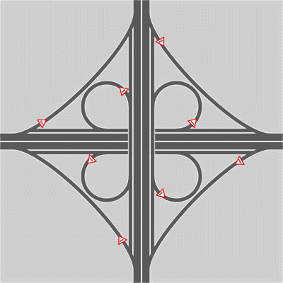
Especially note that traffic coming from the inner loop ramps must yield. However, in the I‑10/Loop 1604 interchange, traffic on those inner loop ramps does not have to yield. Instead, the yield signs are placed on the collector roads, as shown here:
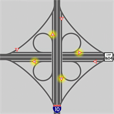
(Note that there are also two changes from the typical yield placement on the outer right-turn ramps, specifically in the northeastern and southeastern quadrants. However this anomaly is incidental to this discussion.)
So how does this actually prevent worse congestion? Because during peak traffic periods, requiring traffic on those inner loop ramps to yield could cause those inner ramps to lock-up. Just like congestion on a grid of one-way streets can eventually lead to "gridlock" because each street's backup blocks the intersecting streets' egresses, congestion in a cloverleaf can lead to what I call "cloverlock". If that happened, then the result would be monumental congestion.
Here's an example of how "cloverlock" could occur and the ramifications if it did:
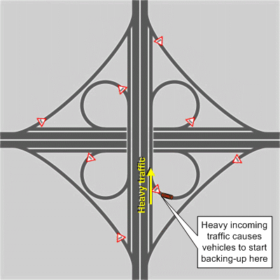
1. Heavy traffic coming into the interchange from the south causes traffic in SE loop ramp to start backing-up:
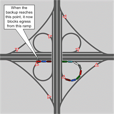
2. As that traffic backs-up, it wraps back around the ramp and eventually reaches the point to where it blocks egress from the SW loop ramp, thus causing traffic to backup on it:
3. Now traffic backs-up along that ramp and eventually reaches the point where it blocks the NW loop ramp:
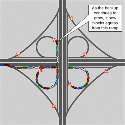
4. Before long, the resulting backup blocks the NE loop ramp:
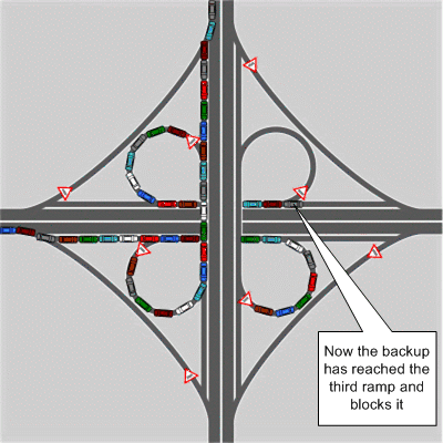
5. Finally, the backup reaches all the way back to where it started and blocks egress from the SE loop ramp:
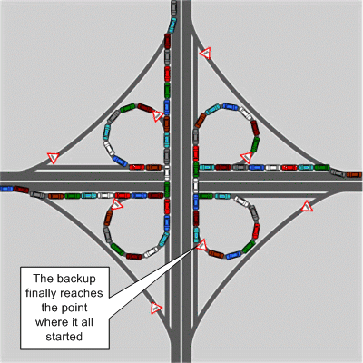
At this point, all the loop ramps are blocked by the backup from the next downstream ramp, creating a self-perpetuating lock-up of those ramps. No traffic can get out of the interchange, which means no additional traffic can get into the interchange. This would cause apocalyptic backups on both I‑10 and Loop 1604.
So by switching the yield signs so that traffic exiting those inner loop ramps always has the right-of-way, a possible lock-up of the interchange is prevented. Obviously, this isn't the perfect solution, but it's a far better scenario than "cloverlock"!