|
||
|
|
||
This page last updated July 21, 2026 |

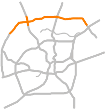 An expansion of Loop 1604 from Bandera Rd. to I‑35 North has been in the works since the beginning of this century. Due to severe funding limitations for much of the past two decades, those expansion plans necessarily included tolled lanes, and a series of issues over the years repeatedly delayed the project.
In the past decade, increases in state highway funding and the resulting deprecation of tolling have resulted in the toll component of this expansion being removed. Instead, plans now are to expand Loop 1604 by adding two non-tolled general-purpose lanes and one HOV lane in each direction. This project will also replace the obsolete cloverleaf interchange at I‑10.
Below is complete information about the latest status of this project.
|
ADVERTISEMENT |
On this page:
Project description
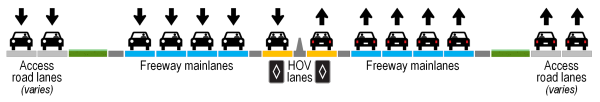
This massive $1.3 billion project will expand Loop 1604 from Bandera Rd. to I‑35 from two general-purpose lanes in each direction to five non-tolled lanes in each direction (four general-purpose lanes and one HOV lane). Note that some sections may have three, five, or six general-purpose lanes depending on the traffic volume, geometry, or available right-of-way at that particular location, but typically the corridor will have four general-purpose through lanes each way.
This project will also replace the overburdened and obsolete I‑10/Loop 1604 cloverleaf with a fully-directional "Texas stack" interchange. Initial funding was only sufficient for the first two flyovers in the new interchange; however, the Texas Transportation Commission approved additional funding in August 2019 to complete the entire interchange in a single project.
The proximity of the interchange flyover terminals to nearby exits will require a complete re-working of nearly all of the entrance and exit ramps in the vicinity, which in many cases will dramatically change access to adjacent streets and businesses.
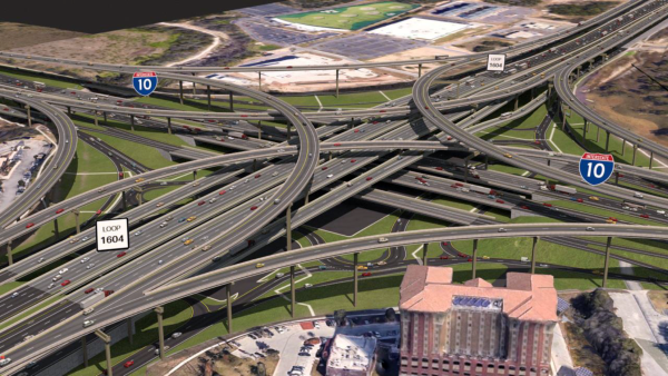
Two sets of new elevated collector-distributor roads on both I‑10 and on Loop 1604 will allow access road traffic headed straight through the interchange to completely bypass the lower-level intersections.
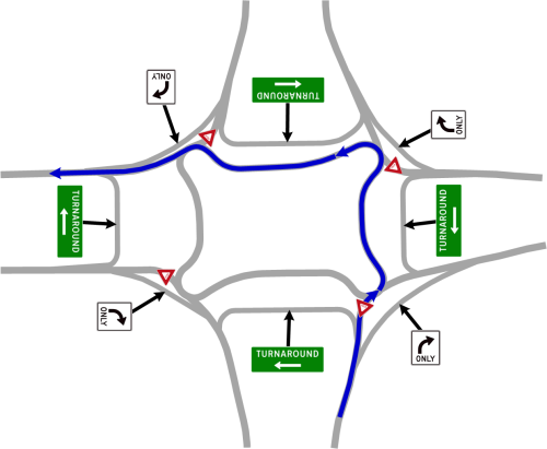
A completely redesigned VIA Park & Ride will remain in the middle of the fidget-spinner.
The Blanco Rd. Diverging Diamond Interchange project, which had previously been planned to be a separate project, has been rolled into the I‑10 to US 281 segment of this project.
New interchange connectors at I‑35 are being built as part of the I‑35 Northeast Expansion (NEX) project. The improvements east of Green Mountain Rd. planned as part of the Loop 1604 Expansion project are designed to integrate with those connectors.
Finally, this project will make numerous entrance and exit ramp revisions and access road improvements. One of the more notable ramp improvements will be to add a dedicated westbound exit ramp to Hausman Rd. and a dedicated eastbound entrance ramp from Hausman Rd. As mentioned earlier, the locations of the touch-down points for the elevated connectors in the revamped I‑10/Loop 1604 interchange will also necessitate several ramp changes on both Loop 1604 and on I‑10 in the vicinity of the interchange in order to reduce conflicts and smooth-out traffic flow.
This project — quite remarkably — will be built almost entirely within the existing right-of-way. This is because planners of the original Loop 1604 back in the 1960s acquired enough right-of-way for this eventuality.
Funding and contracting constraints will require the project to be divided into multiple phases. The first five phases from Bandera Rd. to Judson Rd. are now under construction with substantial funding coming from the Texas Clear Lanes project, an initiative of the Texas Transportation Commission to help advance projects to reduce congestion in the state's five major metro areas.

Phase 1: Bandera Rd. to I‑10
- Status: Substantially complete
- Timeline: Construction started in May 2021 and is substantially complete
- Construction cost: About $150 million
This phase included the following major components:
- Eight non-tolled general-purpose freeway lanes (i.e. four in each direction) between Hausman and I‑10 plus auxiliary lanes. With the auxiliary lanes, much of this stretch actually has five general-purpose lanes in each direction.
- Two future high-occupancy vehicle (HOV) lanes (i.e. one in each direction) between Hausman and I‑10. The pavement for the HOV lanes has been laid, but they will not be marked or signed until the interchange at I‑10 is complete; this is because it is not feasible to provide a proper transition area for the ends of the HOV lanes near I‑10 for the short period between when this project is completed and when the interchange will be completed.
- The westbound lanes taper beginning at the Bandera Rd. exit where the right two lanes will be exit-only. Shortly past there, the HOV lane (when it is completed) will end and merge left. Then shortly after that, the left lane will end and merge left. An auxiliary lane from the Hausman entrance is added to the right and becomes an exit-only lane for Braun Rd.
- A new westbound exit ramp to Hausman Rd. and a new eastbound entrance ramp from Hausman Rd.
- Ramp reversals westbound between Hausman Rd. and Bandera Rd. The new westbound Bandera Rd. exit is two lanes. (The two lanes taper to one, but the original plan called for the two lanes to continue to a four-lane access road. However, the additional lane had to be cut from the final plans due to funding issues caused by inflation when the project was let. A future project currently in planning to continue the expansion of 1604 south of here is expected to add the additional lane.)
- Ramp reversals in both directions between Babcock Rd. and Kyle Seale Pkwy. The new westbound exit to Kyle Seale Pkwy. and the new eastbound exit to Babcock are two lanes.
- The westbound exit to Babcock Rd. was closed due to the proximity of the new flyovers from I‑10. Traffic on westbound Loop 1604 to the east of I‑10 wanting to reach Babcock can exit near I‑10 and continue on the access road and a new access road bypass that passes over the La Cantera Blvd. and Chase Hill Blvd. intersections. Traffic on I‑10 wanting to reach Babcock can exit onto the I‑10 access road before reaching Loop 1604 and travel under the interchange, then proceed on the Loop 1604 access road as discussed above.
- High-mast lighting along the entire stretch.
- Updated TransGuide equipment, including full-color dynamic message signs.
Phase 2: Loop 1604/I‑10 interchange
- Status: Construction underway (77% complete)
- Timeline: Construction started in July 2022 and is expected be completed in late 2027
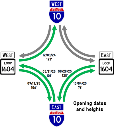
- The first flyover — from eastbound Loop 1604 to westbound I‑10 — is 123' high and opened on December 3, 2024
- The second flyover — from westbound I‑10 to westbound Loop 1604 — is 101' high and opened on May 31, 2025
- The third flyover — from westbound Loop 1604 to eastbound I‑10 is 126' high (128' when lower level work is completed) and opened on August 28, 2025
- The fourth flyover — from eastbound Loop 1604 to eastbound I‑10 is 106' high and opened on September 13, 2025
- The fifth flyover — from westbound I‑10 to eastbound Loop 1604 — is 76' high and opened October 4th, 2025
- The sixth and seventh flyovers — from eastbound I‑10 to both directions of Loop 1604 — are 89' and 66' high and opened November 15th, 2025
- The eighth flyover — from westbound Loop 1604 to westbound I‑10 — is currently 111' high and opened February 5th, 2026 (it will be 126' over the final grade below it)
- Construction cost: About $407 million
- Notes:
- The order of the flyover openings is what worked best for construction sequencing, not traffic demand. Even so, the closing of the corresponding cloverleaf ramps will benefit the traffic that remains in the cloverleaf as the traffic on the new flyovers is removed from the cloverleaf.
- See the FAQ at the bottom of the page for an explanation on why some of the flyovers are only one lane.
- Videos of the opened flyovers at the bottom of this page
This phase will include the following major components:
- All eight new flyover direct-connectors between I‑10 and Loop 1604. (The top two flyovers will be about 125 feet above the ground!) The four highest-volume flyovers will be two lanes; the remaining flyovers will be one lane but will be built wide enough to be re-striped to two lanes in the future if needed. The existing cloverleaf interchange will be demolished in phases as the corresponding new connectors are completed.
- Six general-purpose freeway mainlanes (i.e. three in each direction) will be carried through the interchange on both I‑10 and Loop 1604, and I‑10 will have extra pavement in its median for a future extension of the HOV lanes south from their current terminus near La Cantera Blvd.
- Flyover access road bypasses on both I‑10 and Loop 1604. These will allow through traffic on the access roads to bypass the lower level intersections.
- Replacement of the signalized access road intersections with a continuous flow intersection consisting of four partial roundabouts ("the fidget spinner").
- New access road turnarounds for both directions of I‑10.
- Reconstruction of the VIA Park & Ride.
- Relocation of the westbound exit to La Cantera Blvd. including an intersection flyover bypass at La Cantera Blvd. to allow traffic to access the northern entrances to The Rim without going through the signal at La Cantera Blvd.
- The eastbound exit to UTSA Blvd. will be permanently removed due to its proximity to the new entrance from Loop 1604. Traffic on I‑10 wanting to reach UTSA Blvd. will exit at a new exit in the Loop 1604 interchange and continue on the access road. Traffic on Loop 1604 wanting to reach UTSA Blvd. will have to exit onto the access road on Loop 1604 before reaching I‑10, then turn south (eastbound) onto on the I‑10 access road to reach UTSA Blvd.
- The westbound entrance ramp from UTSA Blvd. will also be permanently removed. Traffic wanting to enter I‑10 or Loop 1604 will continue on the access roads to the next available entrance ramp. This is necessary to smooth traffic flow on the approach to the new Loop 1604 exit, which will be located closer to UTSA Blvd. than the current one.
- The westbound entrance ramp from De Zavala Rd. will be slightly relocated and lengthened.
Phase 3: I‑10 to Stone Oak Pkwy.
- Status: Construction underway (98% complete)
- Timeline: Construction stared in November 2021 and is expected be completed in late 2026
- Construction cost: About $234 million
This phase will include the following major components:
- Eight new non-tolled general-purpose freeway lanes (i.e. four in each direction) plus auxiliary lanes from I‑10 to US 281.
- Two new high-occupancy vehicle (HOV) lanes (i.e. one in each direction) from I‑10 to Blanco Rd. The pavement for the HOV lanes will be laid, but they will not be marked or signed until the interchange at I‑10 is complete; this is because it is not feasible to provide a proper transition area for the ends of the HOV lanes near I‑10 for the short period between when this project is completed and when the interchange will be completed.
- At the eastern end of this phase, the eastbound mainlanes will narrow from four general-purpose lanes to three shortly before reaching the Stone Oak Pkwy. overpass. A fourth mainlane (auxiliary lane) will then be added to the right side from the entrance ramp from Blanco Rd. at the Stone Oak Pkwy. overpass. The two right lanes will then become exit-only lanes to US 281. This is a temporary conifguration until Phase 4 (US 281 to Redland Rd.) is completed.
- On the westbound side, two lanes will enter from US 281 joining the existing two mainlanes coming through the interchange. The far right lane coming from US 281 will merge to the left leaving three through lanes. An auxiliary lane will be briefly added to the right side from the entrance ramp prior to Stone Oak Pkwy. before dropping off at the exit to Blanco Rd./Huebner Rd. just past the Stone Oak Pkwy. overpass. A fourth mainlane will then be added to the left side just past the Blanco/Huebner exit. This layout will also change when Phase 4 (US 281 to Redland) is complete.
- The existing eastbound Lockhill-Selma Rd. exit will be removed and the eastbound access road entrance ramp near I‑10 will be moved to that location. Eastbound Loop 1604 traffic wanting to reach Lockhill-Selma will exit at a new ramp just before crossing over I‑10 for both it and Vance Jackson. Traffic on I‑10 wanting to reach Lockhill-Selma will have to exit on the I‑10 access road prior to Loop 1604 and then turn east onto the Loop 1604 access road to reach Lockhill-Selma (just as you would do to reach Vance Jackson today). This is because the flyovers from I‑10 will not enter Loop 1604 until just past Lockhill-Selma.
- The westbound exit to Lockhill-Selma will be relocated to the same location as the current entrance ramp from NW Military Hwy. and the two ramps will be "braided". This relocation is necessary to smooth traffic flow and better accommodate the elevation differences on the approach to the new I‑10 flyovers.
- The Tradesman Dr. overpass will be removed. This is because it would need to be extended and there was insufficient traffic to warrant the cost. A new westbound to eastbound turnaround will be built at Vance Jackson to help facilitate traffic headed to Tradesman.
- The existing westbound entrance ramp from Rogers Ranch Pkwy./Bitters Rd. will be relocated further east to the current location of the NW Military Hwy. exit, and that exit will then be moved further east to just before Salado Creek. This is intended to help smooth the traffic flow approaching the new I‑10 exit.
- A Diverging Diamond Interchange will be built at Blanco Rd. This will include the construction of collector-distributor roads alongside Loop 1604 between Huebner Rd. and Stone Oak Pkwy. and associated ramp changes. See the Loop 1604 at Blanco Rd. project page for more details on this component of the project.
- Unlike the I‑10 to Bandera Rd. segment that will use high-mast lighting, this section will use conventional double-sided mast-arm streetlights on the center barrier.
- Updated TransGuide equipment, including full-color dynamic message signs.
Phase 4: Stone Oak Pkwy. to Redland Rd.
- Status: Construction underway (60% complete)
- Timeline: Construction started in April 2024 and is expected be completed in late 2027
- Construction cost: About $135 million
This phase will include the following major components:
- Multiple new non-tolled general-purpose freeway lanes plus one high-occupancy vehicle (HOV) lane in each direction. The number of lanes varies throughout this section due to the interchange at US 281:
- Through the interchange, there will be three general-purpose lanes and one HOV lane in each direction.
- Heading eastbound, the two lanes from US 281 will be added, making five lanes plus the HOV lane. These six lanes will then begin to taper down to two beginning at the Bulverde exit. The right lane will become an exit-only lane at the Bulverde Road exit. The remaining right lane will then end (merge left) shortly past the Bulverde exit. That will be followed by the HOV lane ending (merge right) a short distance later. Finally, the remaining right lane will end (merge left) shortly before the entrance ramp from Redland Rd. While this is likely to be a significant bottleneck, it is temporary until the next phase to the east (Phase 5) is done.
- Heading westbound, the existing two lanes will widen to four lanes and quickly to five lanes (four general-purpose lanes plus an HOV lane) shortly past the Redland Rd. exit. An additional general-purpose lane will be added from the Redland Rd. entrance ramp. The two right lanes will then become exit-only lanes to US 281, leaving the three general-purpose lanes plus the HOV lane to continue through the interchange.
- The existing eastbound exit to Bulverde Rd. will be expanded to two lanes (right lane exit-only as discussed above, and an exit/straight option lane).
- This phase will also expand the right turn from the westbound access road onto Stone Oak Pkwy. to two lanes.
- West of Gold Canyon Rd., there will be conventional double-sided mast-arm street lights on the center barrier. East of there will have high-mast lighting.
Phase 5: Redland Rd. to Judson Rd.
- Status: Construction underway (40% complete)
- Timeline: Construction started in March 2025 and is expected be completed in 2028
- Construction cost: About $155 million
This phase will include the following major components:
- Eight non-tolled general-purpose freeway lanes (i.e. four in each direction) plus auxiliary lanes.
- Two high-occupancy vehicle (HOV) lanes (i.e. one in each direction.)
- The eastbound lanes will taper beginning at the Judson Rd. exit where the right lane will be exit-only. Shortly past there, the remaining right lane will end, and shortly thereafter, the HOV lane will end. This is a temporary layout until the next phase to the east is completed.
- On the westbound side, the existing two lanes will widen to the four general-purpose lanes and HOV lane just past the Judson Rd. overpass.
- Ramp reversals for all existing entrance and exit ramps (i.e. the current exit ramps will be switched to entrance ramps and vice-versa.)
- Turnarounds will be added for both directions at O'Connor Rd. and at Judson Rd.
- High-mast lighting along the entire stretch.
- Updated TransGuide equipment.
Phase 6: Judson Rd. to I‑35
This last phase of the expansion was expected to begin construction in late 2028, but is now funded for a late 2026 start.
How this project will help
As anyone who regularly drives Loop 1604 knows, this corridor experiences frequently-recurring congestion due to traffic volumes regularly exceeding the capacity of the road. Adding additional lanes provides the obvious benefit of increasing capacity and thus reducing congestion. Modeling shows that when the project is completed, the corridor should experience continuous free-flow conditions, including during morning and evening peak periods (barring incidents, of course).
Projections for 2045 show that traffic volumes will nearly double. Even so, the modeling shows that by 2045 with the planned expansion, the corridor should still generally see travel times of 25-30% below than today's with the exception being the eastbound morning peak, which could again be at or near current travel times. However, that travel time modeling is for the entire corridor end-to-end; localized sections should still see improved travel times.
HOV lanes are now being added to major freeway expansion projects in San Antonio where feasible. The intent is to encourage carpooling and the use of mass transit. Each person that opts to do so is one less vehicle on the freeway, which helps to reduce congestion and pollution for everyone. Furthermore, HOV lanes help to "future-proof" a corridor by building-in lanes today that can someday be used for new transportation options such as autonomous vehicles. For more information about local HOV lanes, see the HOV lanes page.
The current cloverleaf at I‑10 is obsolete and unable to handle current traffic loads. While this cloverleaf was more than adequate when it was built 40 years ago and for 20-year planning horizon it was designed for, cloverleafs in general are now considered passé in heavy traffic areas as they simply cannot handle contemporary traffic volumes — as this interchange demonstrated during the past decade or so — and nearly all existing cloverleafs in San Antonio are being replaced as a result. Additionally, the weaving maneuvers in a cloverleaf are a major safety issue. The new "Texas stack" interchange here should fully alleviate those issues.
The "fidget spinner" intersection below the I‑10/Loop 1604 interchange will remove the signalized intersections there and should provide a more continuous flow of traffic. A traffic study showed that much of the traffic using the current "box" intersection there was doing so to avoid congestion above, so when the new interchange is complete, the traffic volumes in those access road intersections should be appreciably reduced, and modeling shows the partial roundabouts should be able to handle the expected traffic there more efficiently than signals. The new intersections will also be better positioned to accommodate the driveways in the immediate vicinity.
Finally, the assorted ramp revisions should provide better traffic flow between the mainlanes and access roads.
|
ADVERTISEMENT |
Schematics
Click on one of the letters on the image below to open the detailed schematic for that section of the project. The base schematics are from TxDOT with my own annotations added to help clarify and explain the various elements. Each schematic will open in a new window that you can scroll and zoom.
- The mainlane widening was originally proposed to begin/end just south of Bandera Rd. However, that has now been moved to just south of Hausman, i.e. the mainlanes will remain mostly as they are today south of Hausman.
- The eastbound access road between Bandera and Hausman were planned to be widened, but that has been dropped for now, and the westbound access road will be expanded to three lanes instead of four.
- The HOV lanes on this segment will not be opened as part this project. The pavement for the lanes will be laid, but the lanes will not be marked or signed until the later phases are complete. This is because it is not feasible to provide a proper transition area for the ends of the HOV lanes near I‑10 for the short period between when this project is completed and when the interchange will be completed.
The same situation will happen at the eastern end of Phase 4 — there will be a temporary tapering of the eastbound lanes between Redland Rd. and Bulverde Rd. as discussed in the Phase 4 section above pending the completion of Phase 5. The lane configurations shown in the schematic for that segment are what will exist when Phase 5 is complete. Rinse and repeat for Phase 5, where there will be a temporary tapering of the eastbound lanes between O'Connor Rd. and Judson Rd. until Phase 6 is completed.
Finally, as with Phase 1, the HOV lanes for Phase 3 will not be opened when the rest of the work for that phase is complete. The pavement for the lanes will be laid, but they will not be marked or signed until the interchange at I‑10 is complete. This is because it is not feasible to provide a proper transition area for the ends of the HOV lanes near I‑10 for the short period between when this project is completed and when the interchange will be completed.
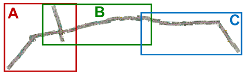
Click on one of the letters on the image above to open the detailed schematic for that section
Videos
Below are videos that discuss Phases 1, 2, and 3 in-depth including a virtual flyover where I explain the new lane and ramp configurations as well as videos from each of the flyover openings.
Phase 1 - Bandera Rd. to I‑10
Phase 2 - Loop 1604/I‑10 interchange
Phase 3 - I‑10 to US 281
First I-10/Loop 1604 interchange flyover
(Eastbound Loop 1604 to westbound I-10)
Second I-10/Loop 1604 interchange flyover
(Westbound I-10 to westbound Loop 1604)
Third I-10/Loop 1604 interchange flyover
(Westbound Loop 1604 to eastbound I-10)
Fourth I-10/Loop 1604 interchange flyover
(Eastbound Loop 1604 to eastbound I-10)
Fifth I-10/Loop 1604 interchange flyover
(Westbound I-10 to eastbound Loop 1604)
Sixth and seventh I-10/Loop 1604 interchange flyovers
(Eastbound I-10 flyovers Loop 1604)
Eighth I-10/Loop 1604 interchange flyover
(Westbound Loop 1604 to westbound I-10)
FAQ
- Will this project be tolled?
No. Although earlier versions of this project proposed adding two tolled managed lanes in each direction, funding was secured to remove the toll component. Instead, two non-tolled mainlanes in each direction plus an HOV lane will be added. - Why didn't they originally build this stretch of Loop 1604 with more than two lanes each way?
The first Loop 1604 freeway sections between I‑10 and I‑35 were planned more than 40 years ago to upgrade the original two-lane farm road to a four-lane freeway. Loop 1604 between Bandera Rd. and I‑10 was planned around 1990 and also was a similar upgrade from the existing two-lane farm road. In both cases, this was a massive improvement — more than quadrupling the capacity of the corridor — that was expected to handle anticipated traffic for the 20 year planning timeline.
When planning a road expansion, engineers look at the projected traffic volumes about 20 years out, and in both cases, those projections showed that four lanes would be sufficient. Indeed, significant recurring traffic congestion didn't develop until the 15 to 20 year mark, which shows the validity of the planning done. Twenty years is the accepted planning horizon because that's the length of time before a road will need major repairs and upgrades simply due to age (i.e. the road's expected lifespan), and because that's the length of time that any traffic projections can be considered even remotely reasonable. Nobody has a crystal ball, so traffic projections are "educated guesses" based on past growth and the best data available for future development in an area, and road capacity is always theoretical — many other factors other than just the number of lanes affect congestion levels. But as a steward of taxpayer dollars, TxDOT cannot spend more than they can empirically justify, a policy I'm sure most taxpayers support to prevent "pork" projects. And spending on extra lanes that may or may not be needed in the future takes away funding for other needed projects. - Why haven't they added more lanes to Loop 1604 North before now? Don't they know how bad the traffic is?
Of course they've known how bad the traffic is, and plans had been in the works to expand Loop 1604 from Bandera Rd. to I‑35 for two decades. However, such an expansion is a very expensive project, now expected to cost over $1 billion. Due to substantial funding shortages that began in the early 2000s, TxDOT was required to incorporate tolling to pay for mega projects like this. With local opposition to tolling and the melodrama over a similar plan on US 281 that delayed that project for over a decade, the plan for 1604 had to be reworked several times. Additionally, because of the project's location over the Edwards Aquifer Recharge Zone, an extensive and lengthy environmental study was required. When new funding mechanisms became available and the toll component was removed from the project, the project had to be redesigned yet one more time. All of those delays added-up. - Why aren't all the flyovers two lanes?
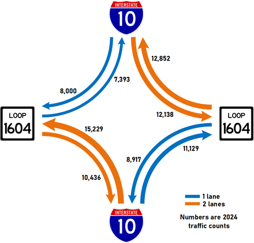
The egress ramp (down-ramp) on each leg can accept three lanes; this is the maximum for safety and efficiency. This means one of the incoming flyovers can be two lanes while the other can be one lane. In each case, the incoming flyover with the highest traffic volume was given two lanes. (See diagram below.) In all cases, the flyovers were built wide enough to accommodate two lanes, so they can be re-striped in the future if relative traffic volumes change. One lane may seem insufficient, but understand that one lane in the new interchange has a substantially higher capacity than one lane in the old interchange, especially for the left-turn movements.
Project history
In the mid to late '80s and early '90s, Loop 1604 was upgraded from a two-lane farm road to a four-lane freeway between I‑10 West and I‑35 North. Subsequent projects in the early and mid '90s extended the freeway to Kitty Hawk Rd. on the east and to Braun Rd. on the west. Since that time, a tremendous amount development has taken place along the 1604 corridor, and traffic counts all along 1604 have increased dramatically. In fact, 13 of the top 20 locations for traffic growth in Bexar County between 1990 and 2016 were along 1604 North, with the location just north of Bandera Rd. showing growth of almost 1000%. Meanwhile, Loop 1604 has struggled to keep up with the explosion of traffic. Several upgrades to the western section south of Braun Rd. have been completed since 1999. However, plans to expand the northern arc from Bandera Rd. to I‑35 North languished for nearly two decades due to several reasons including insufficient funding and delays to required environmental studies. Read on for a more in-depth history of the various machinations this project has gone through.
 What is a managed lane? A managed lane is a lane where the operational strategies of the lane are adjusted in real-time to ensure that the lane remains free-flowing, thus providing for a guaranteed travel time for users of the lane. For example, toll rates or vehicle occupancy requirements may fluctuate based on traffic conditions or time of day. Typically, managed lanes allow toll-free access for buses, carpools, and emergency vehicles, while single-occupancy vehicles (i.e. solo drivers) can use the lane by paying a variable-rate toll. How is this beneficial? Besides providing a clear lane for public transportation and emergency vehicles and encouraging carpooling, it also gives solo commuters who want or need to get where they're going faster an opportunity to bypass congestion by paying a toll to use any excess capacity of the lane. Every motorist who opts to do so removes one more vehicle from the non-tolled lanes, which can help ease congestion. The resulting toll revenue helps to subsidize the road, saving scarce tax dollars for other needed projects. |
Other sites of interest
|
|
TxDOT- Loop 1604 North Expansion https://www.txdot.gov/ |