|
|
|
|
|
This page last updated March 8, 2024 |
Below are historical photos of the Loop 410/San Pedro interchange along with a brief history of the interchange. The photos were sourced from the TxDOT photo library, the San Antonio TxDOT district office, and San Antonio-Bexar County Urban Transportation Study (SABCUTS) planning documents.
This page covers just the Loop 410/San Pedro interchange. For the rest of Loop 410 adjacent to this location, see the Historical Loop 410 Photos (Part 1) page.
Locations are given using the present-day roadway names. Click on each photo for an enlarged view.
Click here to return to the historical photo galleries page.
|
ADVERTISEMENT |
Interchange history
The section of today's Loop 410 between Harry Wurzbach Rd. and NW Military Hwy. was built around 1945 as part of the Harry Wurzbach Military Highway that ran from Fort Sam Houston to Camp Bullis. (More information about the local history of military roads is here.) At San Pedro, which was US 281 at that time, an overpass was built for Harry Wurzbach to safely separate the military traffic from US 281, and four outer ramps provided connectivity between the two roads.
In 1932, engineer Edwin Arneson released his plan for local state highways which included the first proposal for a loop around San Antonio. The state established the first sections of Loop 13 on the South Side in the late '30s to connect Kelly Field and Brooks Field. Around 1950, the first section of Loop 13 on the North Side opened as a two-lane road between San Pedro and US 81 (Austin Hwy.) that mostly appropriated existing roadways — namely, part of the Harry Wurzbach Military Hwy. and Zercher Rd.
In the mid '50s, work started to build the loop from US 90 West to NW Military Hwy. Around 1958, the section between NW Military and McCullough Ave. was then upgraded to an expressway, and the interchange at San Pedro was upgraded to a full cloverleaf.
Interstate 410 was designated in 1959, and the recently-built sections of Loop 13 on the Northwest Side were renumbered accordingly. However, the section on the North Side between I‑10 and I‑35 — including the section here at San Pedro — was actually not included in the original Interstate 410 designation and therefore was designated and signed as State Loop 410 until it was finally officially designated Interstate 410 in 1969. It was reported that the Interstate designation was delayed because there was a disagreement between the state and federal highway officials over this section's design.
North Star Mall opened in 1961 followed by Central Park Mall in 1968. By the late '60s, this intersection had become surrounded by suburban development.
Minor modifications were made to the cloverleaf in the late '90s to address conflicts at the San Pedro Ave./Isom Rd. intersection.
The cloverleaf was removed and the intersection was reconfigured to its current form in 2008 as part of a larger project to widen Loop 410 across the North Side.
|
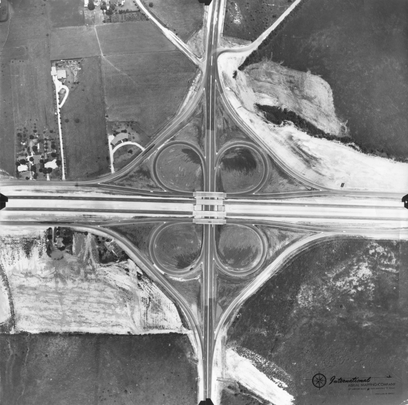
Loop 410 at San Pedro (ca. 1958) (TxDOT/International Aerial Mapping Company) |
|
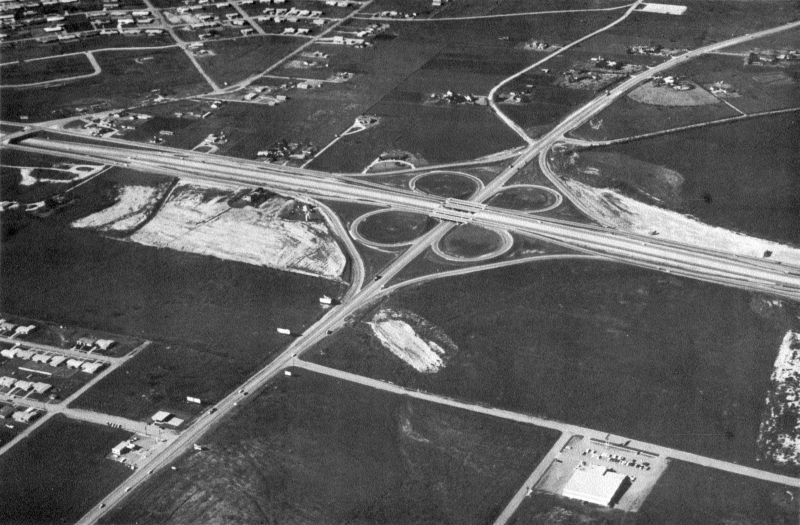
Loop 410 at San Pedro (ca. 1958) (TxDOT/International Aerial Mapping Company) |
|
|
|
|

|
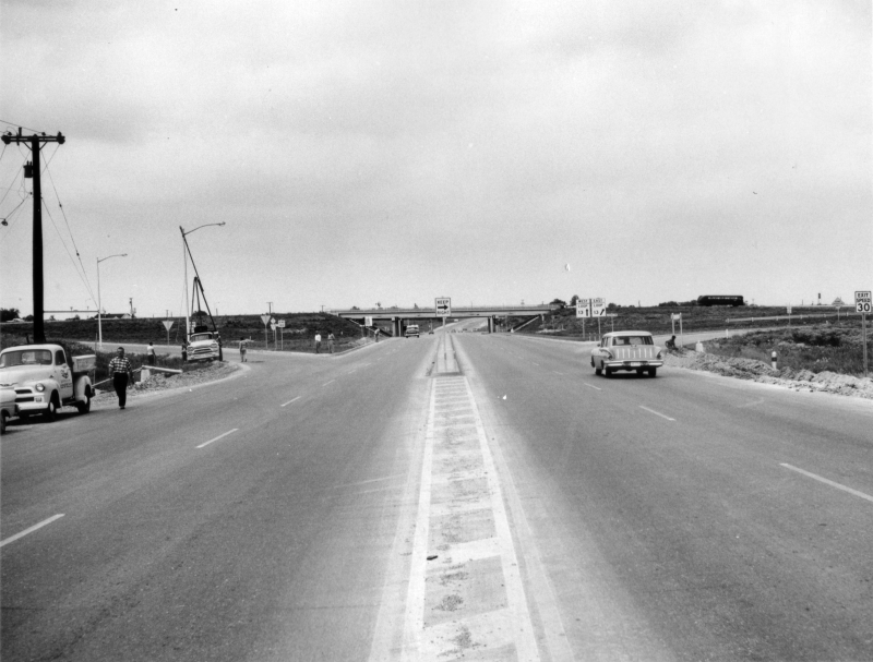
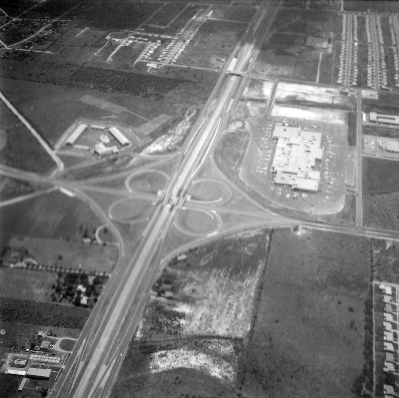
Loop 410 at San Pedro looking southwest (ca.1958) In the distance, you can see Loop 410 was just access roads between NW Military Hwy. and I‑10 as well as in the foreground from McCullough Ave. east; only the stretch between McCullough and NW Military was a freeway at this time. Work had not yet started on North Star Mall, but in the foreground, the first houses in Crownhill Park are under construction. At the left-center, the San Pedro Drive-In is visible. (TxDOT) |
|
|
|
|
|
San Pedro at Loop 410 looking northwest (ca. 1958) (SABCUTS) |
|
San Pedro at Loop 410 looking northwest (ca. 1958) (SABCUTS) |
|
|
|
|
|
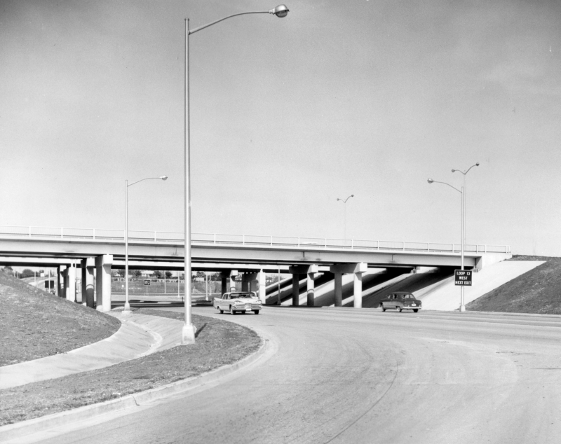
San Pedro at Loop 410 looking north (ca. 1958) The exit signs at the right read "Loop 13" (TxDOT/Les Guthrie) |
|
San Pedro at Loop 410 looking north (ca. 1958) The exit signs at the right read "Loop 13" (TxDOT/Les Guthrie) |
|
|
|
|
|
San Pedro at Loop 410 looking northeast (ca. 1958) (TxDOT/Les Guthrie) |
|
San Pedro at Loop 410 looking northeast (ca. 1958) (TxDOT/Les Guthrie) |
|
|
|
|
|
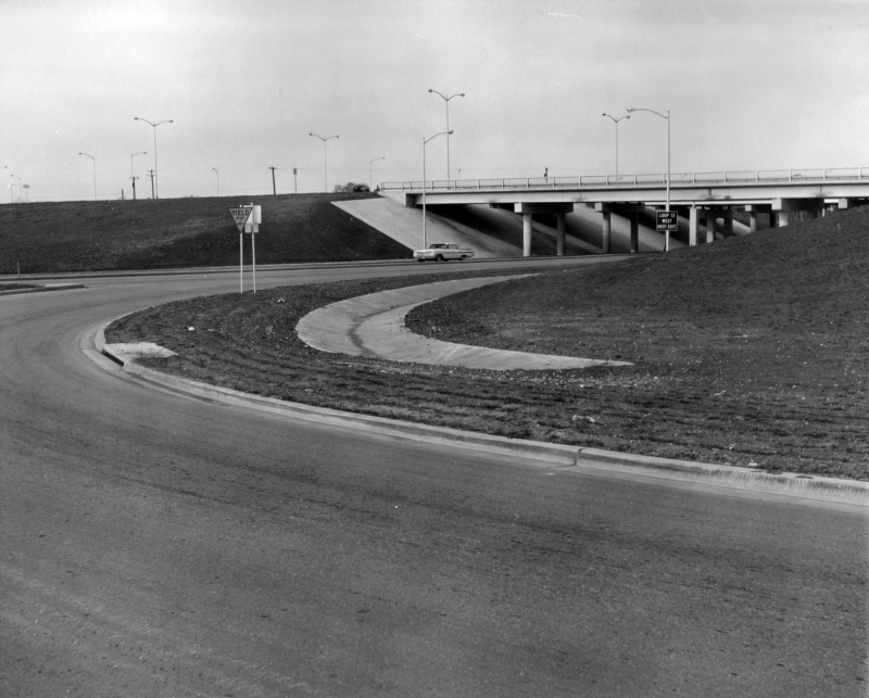
San Pedro at Loop 410 looking northwest (ca. 1958) Note the "Yield right of way" sign (TxDOT/Les Guthrie) |
|
San Pedro at Loop 410 looking northwest (ca. 1958) Note the "Yield right of way" sign (TxDOT/Les Guthrie) |
|
|
|
|
|
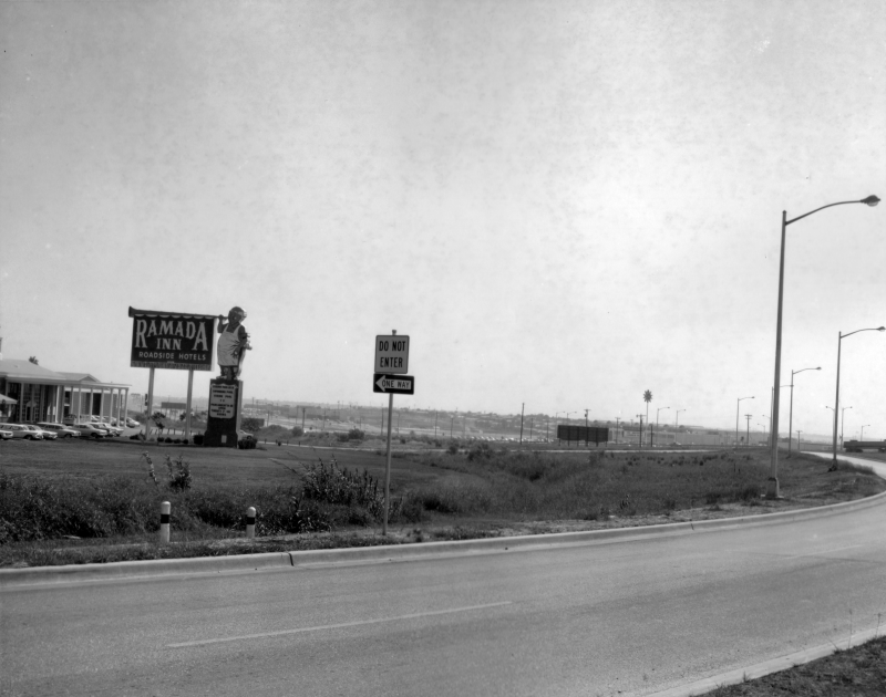
San Pedro at Loop 410 looking northeast (ca. 1959) Construction on North Star Mall was well underway by this time. Across Loop 13, a new Ramada Inn was also under construction. (TxDOT) |
|
San Pedro at Loop 410 looking northeast (ca. 1959) Construction on North Star Mall was well underway by this time. Across Loop 13, a new Ramada Inn was also under construction. (TxDOT) |
|
|
|
|

|
Loop 410 at San Pedro looking northeast (1960) (TxDOT) |
|
Loop 410 at San Pedro looking northeast (1960) (TxDOT) |
|
|
|
|

|
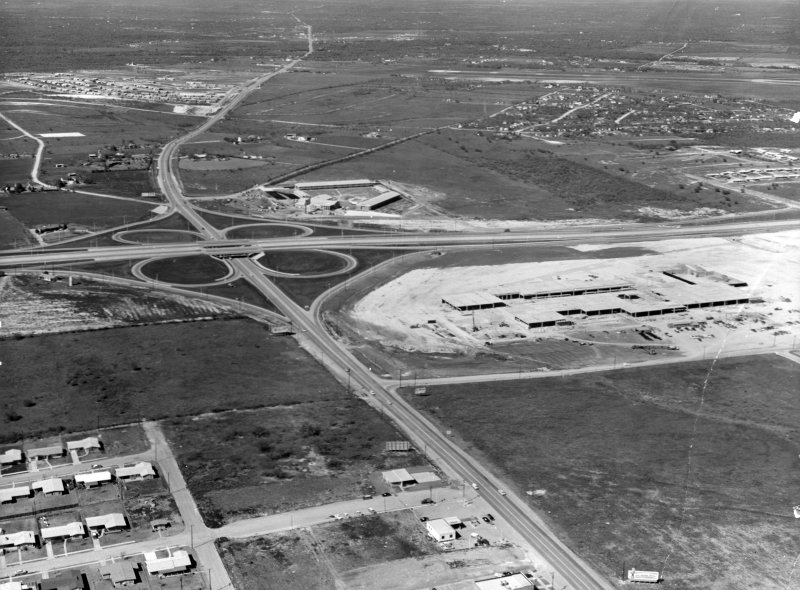
Loop 410 at San Pedro looking west (1960) (TxDOT) |
|
Loop 410 at San Pedro looking west (1960) (TxDOT) |
|
|
|
|
|
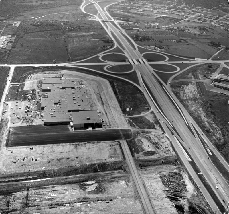
Loop 410 at San Pedro looking west (1960) This is the same view as the previous photo but with all of North Star Mall in view. (TxDOT) |
|
Loop 410 at San Pedro looking west (1960) This is the same view as the previous photo but with all of North Star Mall in view. (TxDOT) |
|
|
|
|
|
San Pedro at Loop 410 looking southeast (ca. 1960) (TxDOT) |
|
San Pedro at Loop 410 looking southeast (ca. 1960) (TxDOT) |
|
|
|
|
|
Loop 410 at San Pedro looking east-northeast (1961) (TxDOT) |
|
Loop 410 at San Pedro looking east-northeast (1961) (TxDOT) |
|
|
|
|

|
Loop 410 at San Pedro looking northwest (1961) (TxDOT) |
|
Loop 410 at San Pedro looking northwest (1961) (TxDOT) |
|
|
|
|

|
San Pedro at Loop 410 looking northeast (ca. 1980) (TxDOT/Weissgarber) |
|
San Pedro at Loop 410 looking northeast (ca. 1980) (TxDOT/Weissgarber) |
|
|
|
|
|
Loop 410 at San Pedro looking northwest (1987) (TxDOT) |
|
Loop 410 at San Pedro looking northwest (1987) (TxDOT) |
|
|
|
|
|
San Pedro at Loop 410 looking south (1993) The Remada Inn had been torn-down by this time. (TxDOT) |
|
San Pedro at Loop 410 looking south (1993) The Remada Inn had been torn-down by this time. (TxDOT) |
|
|
|
|
|
Loop 410 at San Pedro looking east (2001) The iconic Central Park Mall sign is visible at the lower right. (TxDOT) |
|
Loop 410 at San Pedro looking east (2001) The iconic Central Park Mall sign is visible at the lower right. (TxDOT) |
|
|
|
|
|
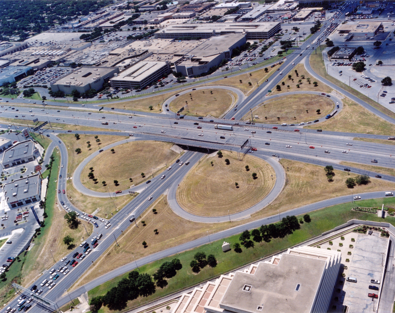
San Pedro at Loop 410 looking southeast (2001) (TxDOT) |
|
San Pedro at Loop 410 looking southeast (2001) (TxDOT) |
|
|
|
|
|
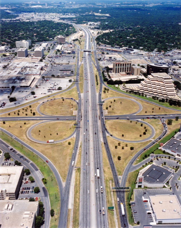
Loop 410 at San Pedro looking west (2001) (TxDOT) |
|
Loop 410 at San Pedro looking west (2001) (TxDOT) |
|
|
|
|