|
||
|
|
||
This page last updated June 27, 2025 |

|
|
|
|
This page covers the proposed Kelly Parkway in Southwest San Antonio. Length: Approximately 12 miles |
|
ADVERTISEMENT |
Description
Since its closure in 2001, the former Kelly AFB has been redeveloped as a major industrial park and inland port first known as KellyUSA and now as Port San Antonio. With the growth of the new inland port, it was expected that traffic in and around the area would increase, especially truck traffic. Therefore, part of the redevelopment effort included the proposed construction of a new roadway connecting US 90 with I‑35 South, Loop 410 South, and SH 16 South. It was envisioned that this roadway would also provide improved access to the Toyota truck assembly plant and adjacent developments in southern Bexar County.
In 2003, the City of San Antonio added the parkway to its Major Thoroughfare Plan. This designation included an extension of the parkway from SH 16 to the east all the way to I‑37, and in 2005, Congress approved $400,000 for right-of-way acquisition.
Since then, interest in the project seems to have quickly waned. The various projects fell out of the MPO's subsequent short-term plans, and the parkway for a while was changed to a toll project in the long-term plan before being quietly dropped from the 2015 plan. As of today, the parkway is still not in the long-term plan and there is currently no funding nor any timetable for it. Initial impediments were the cost and impact of right-of-way acquisition and severe state funding shortages. Then, in 2009, Union Pacific opened a new multi-modal terminal near Von Ormy that transferred a significant amount of the expected freight traffic at Port San Antonio out of the area, thus annulling a major need for the route.
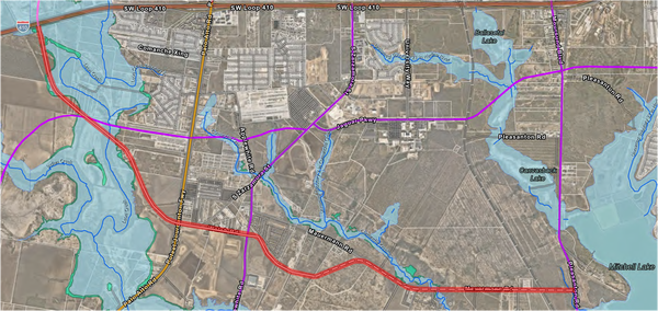
The parkway remains in the city's throughfare plan, but in 2025, the city downgraded the section south of Loop 410 from a "super-arterial" to a secondary arterial road, and the section east of Applewhite Rd. was realigned to mostly use Mauermann Rd. and to end at Pleasanton Rd. The former segment east of Pleasanton Rd. was transferred to the newly designated South Texas Parkway envisioned to stretch across the South Side from I‑35 to I‑37.
The "Kelly Crossroads" junction of General Hudnell Dr., Cupples Rd., Frio City Rd., and Quintana Rd. would be reconfigured, and a three-level interchange would be built along with direct connectors from Kelly Parkway to the Port San Antonio main entrance.
South of the Kelly Crossroads, the route would use the UPRR right-of-way west of and parallel to Quintana Rd. Interchanges would be built at Southcross Blvd. and at SW Military Dr. After crossing under SW Military Dr., the parkway would then turn south running adjacent to the CPS right-of-way to I‑35 with an interchange at New Laredo Hwy. (Loop 353) and an interchange at I‑35 with three flyovers connecting southbound Kelly to northbound I‑35, northbound I‑35 to northbound Kelly, and southbound I‑35 to southbound Kelly.
South of I‑35, the route would run along the western edge of the Leon Creek floodplain. At Loop 410, the parkway would pass over Loop 410. An interchange would be built at Loop 410 with three flyovers: southbound Kelly to eastbound Loop 410, eastbound Loop 410 to southbound Kelly, and northbound Kelly to westbound Loop 410. Frontage road intersections would facilitate the other movements.
South of Loop 410, the route would turn southeast meeting SH 16 at Zarzamora St. An elevated connector would connect northbound SH 16 to northbound Kelly Pkwy.
The eastern extension listed in the city's thoroughfare plan would travel east roughly along Mauerman Rd. before turning southeast to cross Pleasanton Rd. and US 281 south of Mitchell Lake. It then would follow Blue Wing Rd. to I‑37. An amendment in 2021 shifted the segment between Pleasanton Rd. and US 281 slightly south to avoid the new Navistar International truck plant, and a short section of two-lane roadway was built adjacent to the plant.