|
||
|
|
||
This page last updated June 25, 2026 |

|
|
|
|
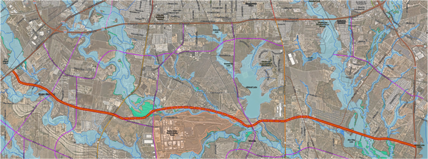
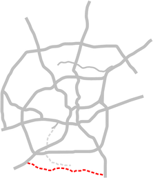
This page covers the proposed South Texas Parkway in South San Antonio. Length: Approximately 15 miles |
|
ADVERTISEMENT |
Description and history
With the closure of Kelly AFB in 2001 and the planned redevelopment of the former base into a logistics hub, a new expressway — the Kelly Parkway — was planned to connect US 90 to SH 16 near the Toyota plant on the South Side. City planners, realizing the potential for future development of the area south of Loop 410, extended the planned route east all the way to I‑37. Several other fractured and circuitous east-west routes in the vicinity were also added to the city's thoroughfare plan.
For a variety of reasons, the Kelly Parkway has never been built. In 2025, with increasing development in the area south of Loop 410, city planners revisited the thoroughfare plan for the sector and determined a likely future need for a true high-capacity east-west route connecting I‑35 and I‑37 between Loop 410 and Loop 1604 much like Wurzbach Parkway on the North Side. To that end, they stitched together a few existing planned roadway segments with a new middle segment near the Toyota plant to create the South Texas Parkway. The eastern segment usurped the previous section of the planned Kelly Parkway east of Pleasanton Rd. and the planned Kelly Parkway route was realigned to end at Pleasanton Rd. approximately a mile north of the previous routing.
The South Texas Parkway has been designated as a freeway in the thoroughfare plan, meaning that sufficient right-of-way will be reserved for a full expressway or freeway. The City Council approved the designation in May 2025, and the Alamo Area Metropolitan Planning Organization subsequently approved adding the route to the region's long-term plan, making it eligible for eventual state and federal funding.