Home | About me | Contact | What's new | Privacy | Search
 

San Antonio
Freeway system
  Primer
  Fwy system history
  2021 traffic statistics
  The freeways
    I-10 East
    I-10 West
    I-35 North
    I-35 South
    I-37
    Kelly Pkwy
    Loop 410 (I-410)
    Loop 1604
    SH 151
    Spur 371
    US 90 West
    US 281 North
    Wurzbach Pkwy
  Construction projects
    I-10E Exp (Graytown)
    I-10E/Loop 410
    I-10 Boerne area
    I-35 Comal Projects
    I-35 NEX
    Loop 410/SH 151
    Loop 410/US 281
    LP 1604N Expansion
    LP 1604/Blanco
    LP 1604/FM 78-I-10
    LP 1604/I-35-FM 78
    SH 151 Expansion
    US 90W Expansion
    US 90/Loop 410
    US 281N Expansion
    US 281 Comal Exp
    US 281/Basse
    US 281/Jones-Mltsbrg
    Wurzbach/NW Military
  Etcetera
    HOV lanes
    Media galleries
    Tollway system
    TransGuide
    10/1604 yield signs
    History of 281/410
Other roads
History
FAQs

Search this site
 
This site is not affiliated with any official agency.


Buy Me a Coffee at ko-fi.com

If you found this site informative, please consider making a small donation to help support it. Thanks!


ADVERTISEMENT

SP 371 San Antonio Area Freeway System
State Spur 371 (General Hudnell Drive)

This page last updated February 12, 2023

Spur 371 highlight map This page covers State Spur 371 from US 90 to Port San Antonio (the former Kelly Air Force Base.)

Length: 1.7 miles


ADVERTISEMENT

On this page

Overview
 
Roadway
details
Lanes Access
roads
       
Exits
 
Speed
limits
Special features
& notes
Traffic
       
 
 Media
gallery
Construction
projects
Future
plans
History


Overview

This short freeway provides access from US 90 to the Port San Antonio inland port and industrial park. The route runs mostly along a railroad with residential areas fronting the opposite side.


Roadway details

LANES
  • 4 lanes from US 90 to Frio City Rd.
  • 6 lanes from Frio City Rd. to Billy Mitchell Blvd.

Spur 371 lanes map


ACCESS ROADS


There are no access roads along this freeway.

 
EXITS


SOUTHBOUND:

  • Quintana Rd./East Kelly Railport
  • Freeway ends at Billy Mitchell Blvd.

NORTHBOUND:

  • Cupples Rd./Quintana Rd./East Kelly Railport
  • Frio City Rd.
  • Freeway merges into US 90 eastbound
 
SPEED LIMITS
  • 55 mph from US 90 to Cupples
  • 40 mph from Cupples to Port San Antonio entrance

Spur 371 speed limits map


SPECIAL FEATURES & NOTES
  • The interchange at US 90 only facilitates traffic from westbound US 90 to Spur 371 and from Spur 371 to eastbound US 90 

Spur 371 speed limits map


TRAFFIC


Generally light traffic volumes. Traffic counts dropped substantially after the closing of Kelly AFB in 2001, then recovered a bit as logistics operations opened at Port San Antonio, but have stagnated in recent years even with the new development there..


AVERAGE ANNUAL DAILY TRAFFIC
LOCATION 2001 2011 2016 2019 2020 2021 '11-'21
% CHG
S of US 9017,30014,40015,76115,39612,93414,378-0.15%
At Port SA21,00015,20012,84414,80112,43310,938-28.04%
 

Media gallery

Click here for photos and video of this freeway.


Construction projects

No current projects in this corridor.


Future plans

Over the past two decades, the former Kelly AFB has been converted into a major industrial park and inland port named Port San Antonio (previously named KellyUSA.) As Port San Antonio grows, traffic in and around the area has grown and is expected to continue to do so. Therefore, part of the redevelopment plans included the proposed construction of an expressway (Kelly Parkway) connecting US 90 with I-35 South, Loop 410 South, and SH 16 South; Spur 371 would comprise the northernmost section of that corridor. Improvements to the interchange at US 90 would be included. However, there is presently no timetable or funding for those projects.


History

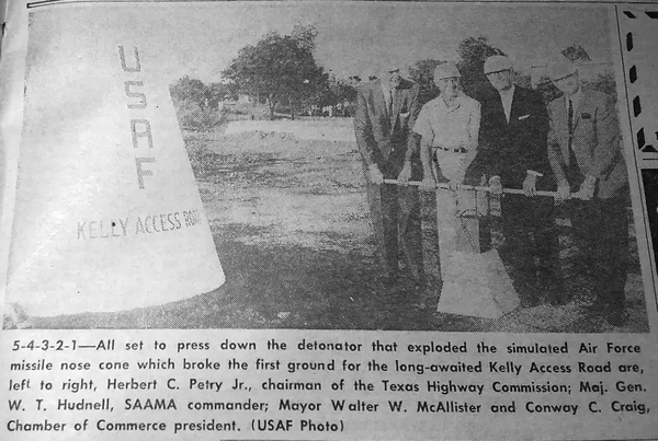
Authorized by Minute Order 51835 (September 25, 1962). It originally had the unimaginative title of "Kelly Access Road", but its name was changed to General Hudnell Drive shortly after it opened. Major General William Hudnell retired as commander of Kelly AFB in 1965.

  • September 1964: Construction began with a ceremony attended by 500 people. The "groundbreaking" was done using an oversized plunger that detonated a simulated missile warhead, ostensibly symbolizing the importance of access to Kelly AFB to the nation's security during the Cold War.
  • 1967: Freeway was completed and open to traffic.


This page and all its contents are Copyright © 2023 by Brian Purcell

NOTICE
The information provided on this website is provided on an "as-is" basis without warranties of any kind either express or implied.  The author and his agents make no warranties or representations of any kind concerning any information contained in this website.  This website is provided only as general information.  The author expressly disclaims all liability with respect to actions taken or not taken based upon the information contained herein or with respect to any errors or omissions in such information.  All opinions expressed are strictly those of the author.  This site is not affiliated in any way with any official agency.