|
||
|
|
||
This page last updated February 3, 2024 |

|
|
|
|
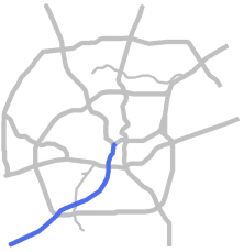
This page covers Interstate 35 west and south of downtown San Antonio from the I‑10 West interchange to Loop 1604. For information on I‑35 north of downtown, see the I‑35 North page. Length: 16 miles |
|
ADVERTISEMENT |
On this page:


Overview
As a result of NAFTA and the development of the Eagle Ford Shale oilfield south of San Antonio, along with industrial and residential growth on the South Side, I‑35 South has become an increasingly important spoke in San Antonio's freeway system. This segment serves the city's southwestern quadrant and continues on to Laredo, the busiest US-Mexico border crossing for trucks. This corridor is also an important component in the continuing development of Port San Antonio.
This segment serves downtown San Antonio, Market Square, the University of Texas at San Antonio downtown campus, the San Antonio Produce Market, South Park Mall, Palo Alto College, Texas A&M University at San Antonio, the Toyota plant and adjacent suppliers, and a growing logistics and industrial area at Loop 410, as well as the cities of Von Ormy and Somerset.
Commercial and industrial development fronts the freeway near downtown. Residential and some commercial development lines the corridor south of US 90 to Somerset Rd. Mostly undeveloped land takes over south of Somerset Rd. to Loop 410. South of Loop 410, light industrial areas and two rail yards sit on the west side of the freeway between Loop 410 and Von Ormy, and residential areas mostly front the freeway through Von Ormy.
Roadway details
| EXITS |
Click here for a list of I‑35 South exits. |
| SPEED LIMITS | |
|
|
|
|

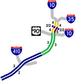
 concurrent (multiplexed) from I‑10 West to US 90
 was concurrent (multiplexed) with I‑35 in Bexar County before it was decommissioned south of Ft. Worth in 1991
| AVERAGE DAILY TRAFFIC | |||||||
| LOCATION | 2002 | 2012 | 2017 | 2019 | 2021 | 2022 | '12-'22 % CHG |
| S of Commerce St. | 155,500 | 169,296 | N/A | ||||
| S of Laredo St. | 160,000 | 175,000 | 177,327 | 171,936 | 160,584 | 173,066 | -1.11% |
| S of US 90 | 146,000 | 146,000 | 155,113 | 158,210 | 159,854 | 161,072 | +10.32% |
| N of SW Military Dr. | 104,000 | 107,000 | 115,550 | 116,128 | 106,517 | 116,950 | +9.30% |
| N of Zarzamora St. | 70,000 | 79,000 | 86,663 | 90,788 | 86,323 | 91,308 | +15.58% |
| N of Cassin Rd. | 37,000 | 43,000 | 49,228 | 50,360 | 48,915 | 51,499 | +19.77% |
| N of New Laredo Hwy. | 34,000 | 39,000 | 46,774 | 48,590 | 46,776 | 49,352 | +26.54% |
| S of Fischer Rd. | 38,000 | 45,000 | 57,722 | 59,644 | 82,263 | 83,046 | +84.55% |
| N of Loop 1604 | 58,644 | 60,225 | N/A | ||||
(NOTE: In 2021, TxDOT changed the location of several traffic counting stations. New stations will show no history prior to 2021, and discontinued stations will show no history for 2021 and thereafter.)
|
ADVERTISEMENT |
Media gallery
Click here for historical photos of this freeway.
Click here for video of this freeway.
Construction projects
There are currently no major construction projects in this corridor.
Click here to view information for all projects in this corridor.
Future plans
The Alamo Area Metropolitan Planning Organization's 25-year plan lists proposals for the expansion of I‑35 to eight lanes from US 90 to the Atascosa County line.
A new expressway (Kelly Parkway) roughly paralleling this section of I‑35 is proposed as part of the Port San Antonio long-range road improvements plan. It would run north from SH 16 near the Toyota plant to US 90 via General Hudnell Dr., crossing I‑35 between Spur 422 and Loop 410.
A fully-directional "stack" interchange at Loop 410 is included in future plans to upgrade SW Loop 410.
History
The first sections to be built were simply called "US 81 Expressway", then the "South Expressway" and "Southwest Expressway" before finally landing on the "PanAm Freeway" as it is a segment of the Pan American Highway. This freeway is also part of the so-called "NAFTA Superhighway". The designation as I‑35 was authorized on October 1, 1959. US 81 was decommissioned south of Fort Worth in 1991.
The section south of New Laredo Hwy. was built in 1934 as part of the Arneson Plan to improve state highways in Bexar County. Prior to then, US 81 and its predecessor SH 2 ran along Frio City Rd., through today's Port San Antonio and Kelly Field, and onto Pearsall Rd.
This was the first expressway spoke in Bexar County to be completed from downtown to the county line, although the section from Loop 410 to the county line was not upgraded to full Interstate standards until 1974.
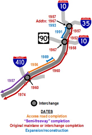
- Late 1930s: The section from I-10 West to Nogalitos St. (and north to Broadway) was included as part of the original three-legged expressway plan for San Antonio designed to provide bypass routes around downtown for through traffic on the various US highways. The United States' entrance into World War II delayed these plans until after the war.
- 1952: The section from Guadalupe St. to Pruitt Ave. (just south of Nogalitos St.) was completed as one of the three spokes of the seminal expressway system.
- 1955: Alignment finalized for the routing of the section between Nogalitos St. and Loop 410. An earlier proposal would have run due south from Nogalitos St. to Southcross Blvd., then southwest to today's intersection of Zarzamora St. and I‑35, then west to join New Laredo Hwy.
- 1956: Access roads between SW Military Dr. and New Laredo Hwy. opened.
- 1957: The elevated "Central Expressway" segment from present-day I‑10 West to Guadalupe St. was completed including the "Downtown Y" interchange. Access roads between SW Military Dr. and New Laredo Hwy. opened, and the pre-existing section of US 81 from New Laredo Hwy. to the Atascosa county line was upgraded to a "semi-freeway", which was a full divided highway with access roads but no overpasses at intersections.
- 1958: Freeway between Nogalitos St. and Division Ave. opened.
- 1960: Freeway between Division Ave. and Fischer Rd. completed including the Loop 410 interchange.
- 1967: Interchange at US 90 completed.
- 1974: Work to upgrade the segment from Fischer Rd. to the Atascosa county line to Interstate standards (mainly adding overpasses and interchanges) was completed.
- 1989: The section from SW Military to Spur 422 expanded from four to six lanes.
- 1988-1991: Section from I‑10 West to US 90 expanded as part of the "Downtown Y" project.
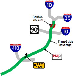
- 1995: TransGuide coverage added from I‑10 West to Southcross Blvd. as part of the original TransGuide project.
- 2009: The section from US 90 to Somerset Rd. was reconstructed. The reconstruction removed several pedestrian bridges, expanded the overpasses and frontage roads, relocated several entrance and exit ramps, removed the previous southbound left-hand exit to SP 422 and the northbound left-hand exit to Palo Alto Rd., and extended the northbound frontage road through the Spur 422 interchange.
- 2023: TransGuide coverage extended from Southcross Blvd. to Loop 1604.
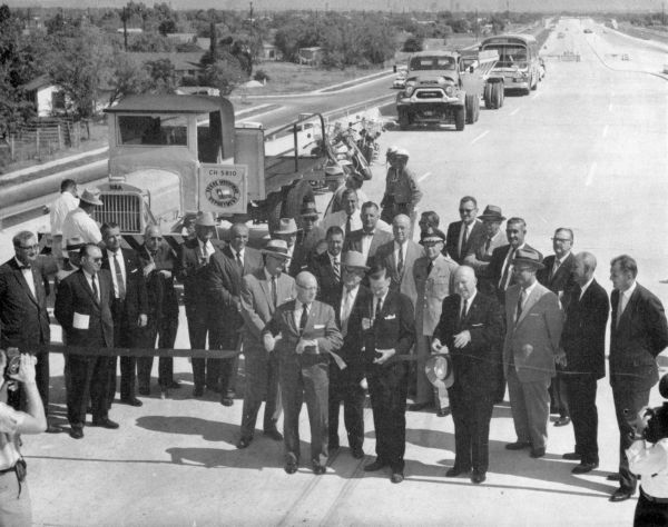
I‑35 ribbon cutting at SW Military Dr. looking north in 1960
(Photo courtesy of TxDOT)
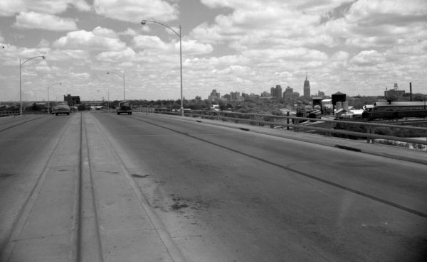
I‑35 over San Marcos St. looking north ca. 1955
(Photo courtesy of TxDOT)
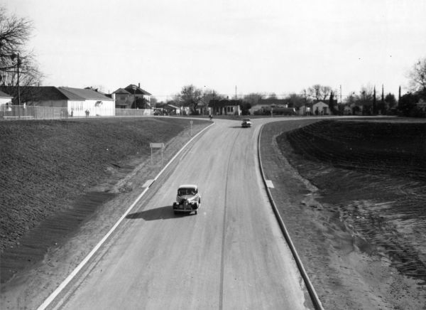
I‑35 at Nogalitos St. looking south ca. 1952
The expressway ended here at this time. Southbound traffic exited onto Nogalitos St., but northbound traffic entered the ramp shown here from Pruitt Ave. This area is now the I‑35/
(Photo courtesy of TxDOT)
|