|
||
|
|
||
This page last updated February 3, 2024 |

|
|
|
|
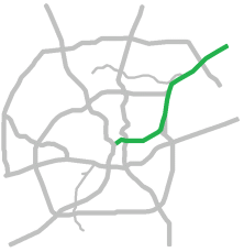
This page covers Interstate 35 north of downtown San Antonio from the I‑10 West interchange to FM 482 in Schertz. For information on I‑35 continuing north, see the San Antonio-Austin Corridor page. For details on I‑35 south of downtown, see the I‑35 South page. Length: 20 miles |
|
ADVERTISEMENT |
On this page:


Overview
This freeway serves the northeast corridor and provides access to Joint Base San Antonio Fort Sam Houston and Randolph, Brooke Army Medical Center, the Frost Bank Center and Freeman Coliseum, the headquarters for Randolph Brooks Federal Credit Union, Retama Park racetrack, the Forum and Live Oak Town Center shopping centers, a significant portion of the region's warehouse space, and the suburban cities of Kirby, Windcrest, Live Oak, Converse, Universal City, Selma, and Schertz.
The route is entirely urban and suburban, and the majority of the adjacent land use consists of warehouse, light industry, and heavy commercial development.
This route is also the southern continuation of the San Antonio-Austin Corridor, is part of the so-called "NAFTA Superhighway", and is on one leg of the Pan American Highway.
Roadway details
| EXITS |
Click here for a list of I‑35 North exits. |
| SPEED LIMITS | |
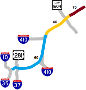
|
|
|
|
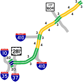
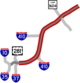
 concurrent (multiplexed) from Loop 410 South Cutoff to Fratt Interchange
 was concurrent (multiplexed) with I‑35 in Bexar County before it was decommissioned south of Ft. Worth in 1991
| TRAFFIC | |
|
|
Heavy to extremely heavy along entire route. This route experiences significant recurring bi-directional morning and evening congestion throughout most of the corridor. 
|
|
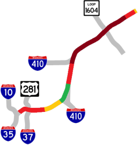
| AVERAGE DAILY TRAFFIC | |||||||
| LOCATION | 2002 | 2012 | 2017 | 2019 | 2021 | 2022 | '12-'22 % CHG |
| N of FM 2252 | 82,000 | 114,000 | 120,233 | 117,327 | 142,456 | 132,938 | +16.61% |
| N of Cibolo Valley Dr. | 85,000 | 118,000 | 121,936 | 126,373 | 151,947 | 155,912 | +32.13% |
| S of FM 3009 | 108,000 | 144,000 | 153,820 | 148,484 | 182,384 | 186,124 | +29.25% |
| Bexar/Guadalupe line | 124,000 | 153,000 | 172,800 | 171,758 | 217,401 | 222,111 | +45.17% |
| S of Loop 1604 | 109,000 | 164,000 | 165,061 | 183,775 | N/A | ||
| N of O'Connor Rd. | 160,000 | 178,000 | 197,824 | 232,237 | 236,781 | 231,683 | +30.16% |
| S of Thousand Oaks Dr. | 188,000 | 205,000 | 218,058 | 235,528 | 243,909 | 237,645 | +15.92% |
| N of Walzem Rd. | 171,000 | 188,000 | 191,564 | 202,221 | 218,126 | 202,265 | +7.59% |
| S of Walzem Rd. | 173,000 | 184,000 | 210,091 | 212,846 | 183,715 | 170,062 | -7.58% |
| S of Rittiman Rd. | 182,000 | 188,000 | 179,075 | 204,463 | 175,867 | 183,254 | -2.52% |
| N of George Beach Ave. | 115,000 | 111,000 | 124,529 | 124,240 | 101,569 | 94,172 | -15.16% |
| N of Salado Creek | 135,000 | 136,000 | 142,003 | 143,756 | 151,727 | 140,421 | +3.25% |
| W of New Braunfels Ave. | 157,000 | 156,000 | 166,941 | 175,710 | 183,377 | 169,816 | +8.86% |
| S of St. Mary's St. | 187,000 | 195,000 | 196,505 | 196,852 | 220,106 | 196,854 | +0.95% |
(NOTE: In 2021, TxDOT changed the location of several traffic counting stations. Discontinued stations will show no history for 2021 and thereafter.)
|
ADVERTISEMENT |
Media gallery
Click here for historical photos of this freeway.
Click here for video of this freeway.
Construction projects
- The massive I‑35 NEX project is double-decking the freeway from Walters St. to FM 1103. Click here for details on this project.
Click here to view information for all projects in this corridor.
Future plans
With the majority of this corridor now undergoing expansion as part of the the I‑35 NEX project, there are no other future plans for this freeway at this time.
History
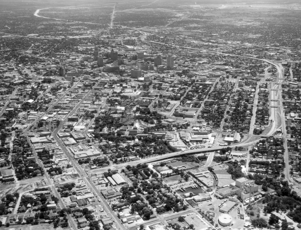
The first sections to be built were simply called "US 81 Expressway" and later the "Northeast Expressway". The designation as I‑35 was authorized on October 1, 1959. It is currently named the "PanAm Freeway" because it is a segment of the Pan American Highway. US 81 was decommissioned south of Fort Worth in 1991.
Most of the section north of Judson Rd. was part of the original route of US 81 and its predecessor SH 2. The short section of Old Austin Rd. at Loop 1604 was bypassed by the current route in 1934 as part of the Arneson Plan to improve state highways in Bexar County. The section between the two Loop 410 interchanges was originally built as a two-lane road as part of Loop 13 in 1953. Finally, the section between Walters and Salado Creek was originally part of the earliest route for SH 3 and US 90 to Seguin.
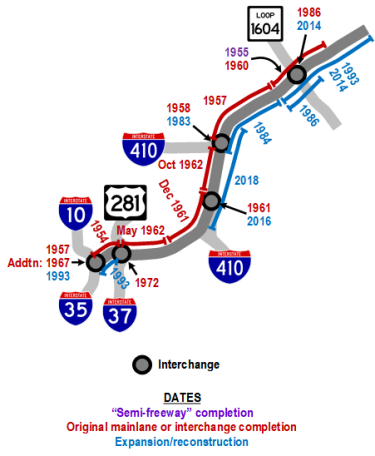
- Late 1930s: The section from I‑10 to Broadway (and south to Nogalitos St.) was included as part of the original three-legged expressway plan for San Antonio designed to provide bypass routes around downtown for through traffic on the various US highways. The United States' entrance into World War II delayed these plans until after the war.
- 1954: The segment from Martin St. to Broadway was completed.
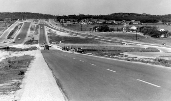
- 1955: The first iteration of the Pat Booker Rd. interchange was completed, and the rest of the pre-existing section of US 81 from Toepperwein Rd. to the county line was upgraded to a "semi-freeway", which was a full divided highway with access roads but no overpasses at intersections.
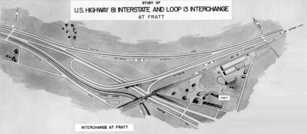
- 1957: The segment from the Fratt Interchange to Toepperwein Rd. was opened, and the "Downtown Y" interchange was completed.
- 1958: Fratt Interchange (I‑35/Loop 410 North) completed.
- 1960: Work to upgrade the segment from Toepperwein Rd. to the county line to Interstate standards was completed.
- December 1961: The segment from Frost Bank Center Dr. (then named Artesia Rd.) to Rittiman Rd. was opened.
- May 1962: The section from Broadway to Frost Bank Center Dr. opened.
- October 1962: Work to upgrade the section between Rittiman Rd. and the Fratt Interchange to a freeway was completed. This section had already existed since around 1952 as a two-lane road that was part of Loop 13. This completion made I‑35 in Bexar County the first Interstate to be fully completed in a metro county in Texas.
- 1967: The ramps connecting I‑35 North to and from I‑10 West in the "Downtown Y" interchange were completed. Prior to this, there were only direct connections between I‑35 South and I‑10 West. Traffic headed to and from I‑35 North had to exit and use the access roads.
- 1972: I‑37/US 281 interchange completed.
- 1980-1986: The section from Loop 410 North (Fratt Interchange) to Toepperwein Rd. was expanded from four to eight lanes, and the section from Toepperwein Rd. to Forum Pkwy. expanded from four to six lanes. The Loop 1604 cloverleaf was built, and the Pat Booker and Fratt interchanges were rebuilt. The Fratt Interchange project was the largest single highway project undertaken by the state up to that time.
- 1983-1993: The section from I‑10 West to I‑37/US 281 was rebuilt and double-decked. This was the last section of the massive "Downtown Y" project to be completed when it opened in 1993.
- 1993: The section from Loop 1604 to FM 3009 was widened from four to six lanes.
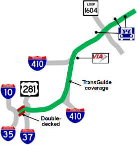
- 1995: TransGuide coverage was added to the section from I‑10 West to New Braunfels Ave. as part of the original TransGuide project.
- 1999: The segment between FM 3009 and FM 482 was widened from four to six lanes in 1999. George Beach Ave. overpass built.
- 2000: TransGuide coverage added to the section from New Braunfels Ave. to Starlight Terrace.
- 2003: TransGuide coverage added from Starlight Terrace to the county line.
- 2008: TransGuide coverage extended from the county line to Austin.
- 2010: Walters St. overpass rebuilt.
- 2014: The section from Loop 1604 to FM 3009 was widened to eight lanes along with interchange improvements at Loop 1604 and an additional southbound lane from Loop 1604 to Judson.
- 2018: The section between the Loop 410 South Cutoff and Loop 410 NE was widened from six to eight lanes and the Loop 410 South Cutoff interchange was reconfigured. New Braunfels Ave. overpass rebuilt.
- 2022: Work begins on the I‑35 NEX project.
|
More historical photos of I-35 are available here. |