|
||
|
|
||
This page last updated October 14, 2025 |

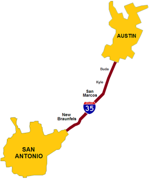
The I‑35 San Antonio-Austin Corridor connects a booming mega-region with an aggregate population of about 5 million people stretching 100 miles from South San Antonio to Georgetown. It is the busiest inter-metro Interstate in Texas, with traffic counts exceeding 100,000 vehicles per day. From south to north, the corridor traverses Bexar, Guadalupe, Comal, Hays, Travis, and Williamson counties, and passes through the cities of San Antonio, Live Oak, Selma, Schertz, Cibolo, New Braunfels, San Marcos, Kyle, Buda, Austin, Round Rock, Pflugerville, and Georgetown.
This page gives an overview of the 48 mile core section of the corridor between the San Antonio and Austin urbanized areas, or more specifically from FM 482 in Schertz to SH 45 near Buda. To continue south, see the I‑35 North page in the San Antonio Area Freeway section of this site.
|
ADVERTISEMENT |
Roadway details
- 6 lanes from FM 482 to Solms Rd.
- 8 lanes in New Braunfels from Solms Rd. to FM 306
- 6 lanes from FM 306 to SH 45
There is a left-lane truck restriction in effect for the entire corridor from just inside Loop 1604 in Live Oak to north of Georgetown.
Originally, the northbound frontage road did not continue over the Guadalupe River in New Braunfels, nor were there frontage roads over the Blanco River in San Marcos, and there was a gap in the southbound frontage road between Kyle Crossing and Kyle Parkway as well as through downtown Kyle where Business 35 functioned as the frontage road. Frontage roads were added at all of those locations during expansion projects between 2000 and 2010.
Prior to 2000, all of the frontage roads between San Antonio and Austin were two-way with the exception of a 2.3 mile one-way section through San Marcos. Expansion projects since 2000 have converted all of the frontage roads in the corridor to one-way. The last section remaining two-way was between Conrads Rd./Kohlenberg Rd. north of New Braunfels and FM 1102/York Creek Rd. near the Comal/Hays county line. Work to convert that section to one-way was completed in 2023, the result of which is that all of the I‑35 frontage roads between the Medina River south of San Antonio all the way to Hillsboro are now one-way.
Traffic
Interstate 35 is the primary freeway tying the San Antonio-Austin region together and, as a consequence, is frequently overloaded on many sections. All counts in the corridor now exceed 100,000 vehicles per day.
In addition to local population and industrial growth, international trade has put an additional strain on the corridor as I‑35 connects the nation's busiest freight border crossings in Laredo to the Midwest, resulting in a high level of truck traffic in this corridor. Consequently, officials lobbied to have it designated as a "NAFTA Superhighway" to secure federal funding for various conventional and ITS improvements, and the entire corridor has been upgraded to a six and eight lane facility over the past two decades.
Future plans
Various frontage road, ramp, intersection, and operational improvement projects at several locations in and south of New Braunfels are in various stages of planning. More details on those projects here.
A statewide planning study for I‑35 in 2016 recommended several expansion projects in the corridor. However, no funding was ever allocated for those projects.
The I‑35 corridor had been mentioned as a possible location for a "hyperloop" transportation system.
State Highway 130

In an effort to alleviate the growing traffic problems in the I‑35 corridor, a parallel tollway, SH 130, was built. For more information, see the the SH 130 page.