|
||
|
|
||
This page last updated February 4, 2024 |

|
|
|
|
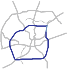
This page covers Interstate 410 (Loop 410) around the city except for the section between the Fratt Interchange (Loop 410 North) and the Loop 410 South Cutoff on the Northeast Side. That section is concurrent with I‑35 and, because the I‑35 mile markers and exit numbers are used along that stretch, information for that segment can be found on the I‑35 North page. Technically, that section is not even officially part of Loop 410 per TxDOT's highway designation files. However, it is signed as both I‑35 and I‑410 for continuity purposes. Length: 49 miles (53 miles including the concurrent section on I‑35) |
|
ADVERTISEMENT |
On this page:


Overview
Interstate 410, known locally as "Loop 410" or, by old-timers, just "The Loop", is really a tale of two freeways. The southern half (south of US 90) generally demarcates the edge of the city and resembles and functions more like a semi-rural or urban fringe Interstate than an urban freeway. Meanwhile, the northern arc is the busiest stretch of freeway in Texas outside of Houston — making it one of the 25 or so busiest in the nation — and is home to a substantial share of the region's suburban office space and several major shopping centers.
Loop 410 provides access to San Antonio International Airport, the South Texas Medical Center, the Southwest Research Institute and Texas Biomedical Research Institute, the Westover Hills area and Sea World of Texas, the National Security Agency campus, Joint Base San Antonio Ft. Sam Houston and Lackland, Traders Village, the Brooks re-development (formerly Brooks City-Base), Stinson Municipal Airport, the San Antonio Missions Trail National Park, Palo Alto College, Texas A&M University - San Antonio, the Toyota and Navistar plants and adjacent facilities, and the cities of Castle Hills, Balcones Heights, Leon Valley, Kirby, and Windcrest.
Land along the northern arc is heavily developed. Office towers, shopping malls, hotels, and other commercial developments dominate the landscape, interspersed with dense mid-20th century residential areas. South of US 90, development is much more dispersed with large tracts of vacant land, although this area has been seeing new residential, commercial, and industrial growth in recent years, most notably a growing logistics and industrial area at I‑35 South. Development along the southern arc is a mixture of light residential, commercial, industrial, and public uses.
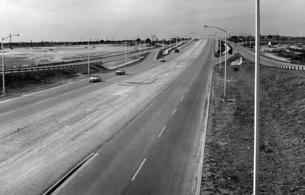
In 2010, TxDOT completed a major decade-long program to expand Loop 410 to ten lanes across most of the northern arc.

|
Loop 410 intersects with I‑35 North at two places: north of Walzem Rd. at the Fratt Interchange, and south of Rittiman Rd. at the 410 South Cutoff. Between those interchanges, Loop 410 runs concurrent with I‑35. |
Roadway details
| EXITS |
Click here for a list of Loop 410 exits. |
| SPEED LIMITS | |
|
|
|
|
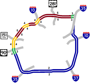
 North from Fratt Interchange to Loop 410 South Cutoff — this section is officially not designated as part of Interstate 410, but is signed as such for continuity purposes
 concurrent along western arc from Bandera Rd. to Poteet-Jourdanton Fwy.
 concurrent from I‑35 South to I‑10 East
 concurrent from I‑37 to Roosevelt Ave.
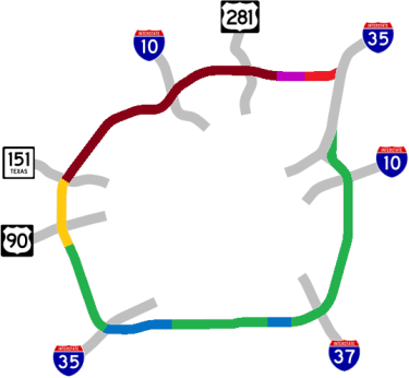
| AVERAGE DAILY TRAFFIC | |||||||
| LOCATION | 2002 | 2012 | 2017 | 2019 | 2021 | 2022 | '12-'22 % CHG |
| E of Perrin-Beitel Rd. | 124,000 | 150,000 | 158,807 | 163,071 | 150,837 | 153,459 | +2.31% |
| W of Perrin-Beitel Rd. | 166,438 | 169,318 | N/A | ||||
| W of Nacogdoches Rd. | 166,000 | 202,000 | 220,817 | 229,058 | N/A | ||
| E of Nacogdoches Rd. | 300,835 | 306,104 | N/A | ||||
| W of Wetmore Rd. | 179,000 | 201,000 | 215,609 | 235,310 | N/A | ||
| E of McCullough Ave. | 182,000 | 265,000 | 278,805 | 291,725 | 281,365 | 286,372 | +8.06% |
| E of Blanco Rd. | 185,000 | 270,000 | 297,977 | 305,674 | 267,693 | 272,435 | +0.90% |
| E of Honeysuckle Ln. | 214,718 | 218,396 | N/A | ||||
| Cherry Ridge Dr. | 195,000 | 249,000 | 265,276 | 276,016 | 280,458 | 283,908 | +14.02% |
| W of Fredericksburg Rd. | 290,292 | 295,345 | N/A | ||||
| W of Evers Rd. | 170,000 | 191,000 | 259,433 | 228,632 | 236,098 | 243,855 | +27.67% |
| S of Bandera Rd. | 158,000 | 190,000 | 212,258 | 218,205 | 236,447 | 226,303 | +19.11% |
| S of Culebra Rd. | 217,522 | 221,338 | N/A | ||||
| N of Marbach Rd. | 140,795 | 143,204 | N/A | ||||
| N of US 90W | 113,000 | 117,000 | 126,899 | 127,248 | 113,034 | 114,920 | -1.78% |
| S of US 90W | 82,000 | 83,000 | 104,373 | 121,514 | 103,402 | 105,057 | +26.57% |
| S of Medina Base Rd. | 91,829 | 93,387 | N/A | ||||
| N of Pearsall Rd. | 51,000 | 54,000 | 71,978 | 76,486 | 68,998 | 70,214 | +30.03% |
| S of Pearsall Rd. | 72,766 | 74,040 | N/A | ||||
| W of I‑35S | 45,000 | 47,000 | 57,595 | 73,410 | N/A | ||
| E of I‑35S | 45,988 | 46,813 | N/A | ||||
| E of Somerset Rd. | 29,000 | 34,000 | 46,480 | 49,450 | 46,956 | 47,757 | +40.46% |
| E of Poteet-Jourdanton Fwy. | 30,000 | 32,000 | 46,378 | 53,146 | 50,605 | 51,436 | +60.74% |
| W of Roosevelt Ave. | 38,000 | 42,000 | 54,753 | 59,670 | 58,048 | 59,079 | +40.66% |
| E of Roosevelt Ave. | 38,000 | 47,000 | 50,234 | 52,761 | 47,189 | 47,973 | +2.07% |
| W of I‑37 | 33,000 | 54,000 | 61,340 | 60,705 | 55,731 | 56,706 | +5.01% |
| E of I‑37 | 36,000 | 57,000 | 56,618 | 56,356 | 54,120 | 55,100 | -3.33% |
| S of Southcross Blvd. | 39,000 | 58,000 | 61,887 | 61,383 | 58,550 | 59,595 | +2.75% |
| S of Rigsby Ave. | 46,000 | 65,000 | 65,675 | 65,688 | 64,697 | 65,832 | +1.28% |
| S of E. Houston St. | 58,000 | 69,000 | 77,712 | 78,559 | 77,434 | 77,783 | +12.73% |
| S of I‑10E | 61,000 | 72,000 | 80,872 | 83,569 | 79,506 | 80,928 | +12.40% |
| N of I‑10E | 68,000 | 88,000 | 82,798 | 82,654 | 80,020 | 82,179 | -6.61% |
| N of FM 78 | 70,000 | 82,000 | 70,331 | 71,815 | 65,960 | 67,079 | -18.20% |
(NOTE: In 2021, TxDOT changed the location of several traffic counting stations. New stations will show no history prior to 2021, and discontinued stations will show no history for 2021 and thereafter.)
|
ADVERTISEMENT |
Media gallery
Click here for historical photos of this freeway.
Click here for video of this freeway.
Construction projects
- WW White Rd. to Rigsby Ave.: Replace cloverleaf interchange at I‑10 with five-level "stack" interchange. Click here for details on this project.
- Valley Hi Dr. to Pearsall Rd.: Ramp reversals and intersection improvements.
Click here to view information for all projects in this corridor.
Future plans
TxDOT has intermediate-term plans to expand the section from US 90 to SH 16 South to eight lanes and replace the I‑35 South cloverleaf interchange with a multi-level flyover interchange. Those projects are currently projected to start in 2032.
A project to make several operational improvements in the Loop 410/US 281/San Pedro area will make substantial changes to exits, intersections, and access roads along Loop 410 between US 281 and West Ave. More details on that project is here.
History
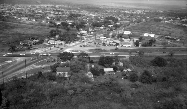
A highway loop around San Antonio was first proposed in 1932 as part of the "Arneson Plan" to improve state highways in Bexar County. That plan lined-out today's Loop 410 between San Pedro and I‑35 North, but had the remainder of the loop closer to downtown than today's route. On the West Side, Arneson's planned route would have used the Acme Rd. and Benrus Blvd. corridors and run between Kelly and Lackland Air Force Bases. On the South Side, most of Arneson's route ran a mile or so south of today's Military Dr., and on the East Side, his route was a bit east of WW White Rd.
Planning for what was often referred to as the "Military Loop" on the North Side during WWII showed the section west of NW Military Hwy. running slightly northwestward to meet Fredericksburg Rd. near Wurzbach Rd.
The city's 1950 master plan, also known as the "Lilly Report", moved that routing a little further south to meet Callaghan Rd. at Fredericksburg Rd. and then follow the Callaghan Rd. corridor — which at that time was still outside the city — from there to US 90. By 1955, however, that route had been scrapped and replaced with the present-day route from NW Military Hwy. around to US 90, then continuing along today's routing around the South Side. This route was chosen to avoid traversing Lackland and Kelly Air Force bases and the increasingly urbanized section of the existing Loop 13 (Military Dr.) on the South Side, and this was the route included in the 1955 blueprint for the Interstate Highway System known as the "Yellow Book".
The first sections to be built in the 1950s were signed as Loop 13 and re-designated as Interstate 410 in 1960. The section on the North Side between I‑10 and I‑35 was not initially included in the Interstate program reportedly due to a dispute over design standards as that section of the loop had already been planned for some time. However, for route number continuity, that section was designated and signed as State Loop 410 until it was finally added to the Interstate Highway System in 1968 and subsequently designated as I‑410 by the Texas Transportation Commission in July 1969.
Loop 410 is named the Connally Loop for Texas Governor John B. Connally. Connally, who served as governor from 1963 to 1969, was from the San Antonio area and was instrumental in helping the city during the HemisFair World's Fair in 1968.
Loop 410 was the first Interstate loop in Texas to be completed.
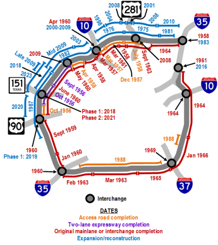
- September 1956: The section between Bandera Rd. Culebra Rd. opens as a two-lane expressway (i.e. one lane each way).
- October 1956: The segment from Culebra Rd. south to Marbach Rd. opens as a two-lane expressway, and the section from Marbach Rd. to US 90 opens as access roads.
- March 1957: Access roads between Vance Jackson Rd. and Cherry Ridge Dr. open along with the mainlanes from Cherry Ridge Dr. to Fredericksburg Rd.
- December 1957: Access roads from San Pedro Ave. to Vance Jackson Rd. open.
- ca. 1958: The section between McCullough Ave. and Blanco Rd. upgraded to a freeway including construction of a cloverleaf interchange at San Pedro Ave.
- April 1958: Access roads between Callaghan Rd. and Bandera Rd. open as well as the mainlanes from Fredericksburg Rd. to Callaghan Rd.
- July 1958: Access roads from Wetmore Rd. to McCullough Ave. open.
- 1960: Interstate 410 designated and signs along existing sections of Loop 13 on the northwest side west of I‑10 are changed to I‑410, while the section east of I‑10 is renumbered and signed as State Loop 410.
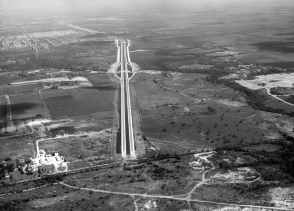
- September 1959: Freeway (mainlains and access roads) from US 90 to Old Pearsall Rd. completed.
- January 1960: Freeway from Old Pearsall Rd. to I‑35 opens including interchange at I‑35.
- April 1960: Interchange at I‑10 West completed.
- May 1960: Mainlanes from Callaghan Rd. to Bandera Rd. completed.
- June 1960: Freeway from Bandera Rd. to US 90 opens including interchange at US 90.
- March 1961: Mainlanes from NW Military Hwy. to Cherry Ridge Dr. completed.
- February 1963: Mainlanes from I‑35 South to Poteet-Jourdanton Fwy. open.
- March 1963: Mainlanes from Poteet-Jourdanton Fwy. to Roosevelt Ave. completed.
- September 1963: Mainlanes from Nacogdoches Rd. to San Pedro Ave. open.
- 1964: Mainlanes from I‑35 North to Nacogdoches Rd. opened, and freeway from Southcross Blvd. to Rittiman Rd. completed including interchange at I‑10 East.
- 1965: Mainlanes from Roosevelt Ave. to S Presa St. open.
- January 19, 1966: Freeway from S Presa St. to Southcross Blvd. opens with ribbon-cutting ceremony for entire Loop 410 completion.
- 1969: Interchange at I‑37 completed.
- July 1969: Interstate 410 designation finally extended to northern section of Loop 410.
- 1975: The section from Harry Wurzbach Rd. to San Pedro Ave. widened to six lanes.
- 1976: The segment from San Pedro Ave. to I‑10 West widened to six lanes.
- 1980-1983: Fratt Interchange rebuilt in a blockbuster project — the largest ever in the highway department's history at that time.
- 1981: The section from Perrin Beitel Rd. to Harry Wurzbach Rd. widened to six lanes.
- 1982: The segment from I‑10 West to Ingram Rd. widened to six lanes.
- 1987: The section from Ingram Rd. to Valley Hi Dr. widened to six lanes.
- 1988: Access roads from Somerset Rd. to Southton Rd. and from WW White Rd. to Southcross Blvd. built.
- 1994: Overpasses at Fredericksburg Rd. and at Cherry Ridge Dr. widened in preparatory projects to accommodate approaches to future I‑10 interchange flyovers.
- 1996: Additional westbound lane added from I‑10 West to Babcock Rd.
- 1998: The segment from Jackson-Keller Rd. to Cherry Ridge Dr. widened to ten lanes but only eight lanes marked to limit bottlenecking. This was the first project in a larger program to widen Loop 410 from I‑35 North to Culebra Rd.
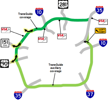
- 1999: First section of TransGuide coverage on Loop 410 installed from I‑35 North to Ingram Rd.
- 2000-2009: I‑10 interchange reconstructed including expanding Loop 410 to eight lanes through interchange.
- 2001: The section between US 281 and McCullough Ave. widened and prepared for the planned 281/410 interchange.
- 2003: The segment from I‑10 West to Callaghan Rd. expanded to ten lanes.
- 2004: The section from Blanco Rd. to Jackson-Keller Rd. widened to ten lanes (eight lanes provisionally marked).
- June 18th, 2007: First ramp in US 281 interchange opened to traffic.
- 2008: The segment from McCullough Ave. to Blanco Rd. widened to ten lanes, and the San Pedro interchange rebuilt. The previously-completed sections between Blanco Rd. and I‑10 West restriped to ten lanes.
- June 2008: US 281 interchange completed including widening Loop 410 to ten lanes from Nacogdoches Rd. to Jones-Maltsberger Rd.
- May 2009: Flyovers to/from Bandera Rd. opened.
- Mid 2009: The segment from Callaghan Rd. to Ingram Rd. widened to eight and ten lanes.
- Late 2009: The section from Ingram Rd. to Culebra Rd. widened to six lanes.
- 2010: The segment from Austin Hwy. to Nacogdoches Rd. widened to ten lanes. This was the last section to be widened as part of the larger Loop 410 widening program that started in 1997.
- 2011: SH 130 signs are added to the section of Loop 410 from I‑35 South to I‑10 East as part of an effort to extend the SH 130 designation from the SH 130 toll road near Seguin to I‑35 to provide a single route number for the entire bypass of I-35.
- 2018: The segment from Ingram Rd. to SH 151 widened to eight lanes, and the first phase of the SH 151 interchange completed.
- 2019: Phase 1 of the US 90 interchange completed.
- 2020: The segment from north of Marbach Rd. to US 90 was reconstructed and expanded to include auxiliary lanes in both directions.
- 2021: Phase 2 of the SH 151 interchange completed.
- 2023: The segment from Ingram Rd. to south of SH 151 expanded from eight to ten lanes. The first flyover — from northbound Loop 410 to eastbound I‑10 — in the upgraded I‑10 East interchange was opened.
|
More historical photos of Loop 410 are available here. |