|
||
|
|
||
This page last updated January 19, 2025 |

|
|
|
|
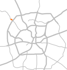
Location
Status
Timeline
|
|
ADVERTISEMENT |
On this page:
Summary
Here is a brief "PowerPoint" summary of this project:
- This project has converted the intersections along Bandera Rd. to "Restricted Crossing U‑turn" (RCUT) intersections from Legend Trail to Diamond K Trail.
- This has modified the intersections at Hausman/Leslie and Cedar Trail to force traffic on those cross streets to turn right, i.e. left turns and straight-through movements from those cross streets are blocked, but left turns from Bandera Rd. to those cross streets is still permitted.
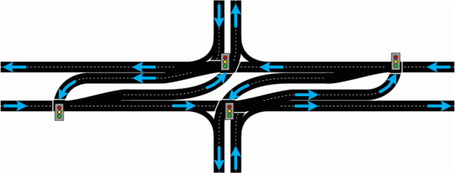
- Downstream turnarounds allow traffic from the cross street to make a U‑turn to return to their intended direction of travel. (See diagrams below.)
- This is the same configuration as at Bandera Rd. and FM 1560 South.
- Doing this reduces the number of traffic signal phases required to move traffic through the intersections, thereby allowing for longer green times for all movements without extending the overall cycle time, or multiple cycles in the same amount of time as one cycle previously. This allows for more traffic to move through the intersection in the same amount of time, thus reducing wait times and congestion. (See explanation below.)
- While it seems confusing at first, it's actually pretty easy to navigate.
- Studies of past RCUTs show both improved safety as well as reduced congestion.
- A new left turn (signalized) has been built from northbound Bandera Rd. to Legend Trail.
- The crossover at Diamond K Trail has been closed.
- Bandera Rd. has been widened to three lanes each direction between Hausman/Leslie and Circle A Trail.
- Based on community feedback, TxDOT directed their consultant to study possible changes at Circle A Trail, but that study determined that the changes desired by local residents would result in increased crashes and congestion due to the disruption that would be introduced by the signal timings required to facilitate left turns from Circle A Trail to SB Bandera Rd. (See further explanation below.)
Project description
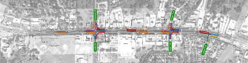
This project converted the intersections on Bandera Rd. at Hausman Rd./Leslie Rd. and Cedar Trail to "Restricted Crossing U‑turn" (RCUT) intersections, added signalized turnarounds at multiple intermediate locations, and closed the crossover at Diamond K Trail. It has also constructed a new signalized left turn from northbound Bandera Rd. to Legend Trail, expanded the southbound Bandera left turn to Hausman to two lanes, and has widened Bandera to three lanes in each direction between Hausman/Leslie and Circle A Trail.
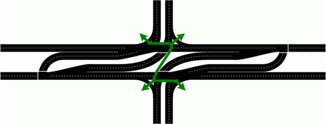
The RCUT intersections prevent traffic on Leslie/Hausman and Cedar Trail from going straight or turning left. Instead, all traffic must make a right turn, then use a signalized turnaround about 1,000 feet downstream to make a U‑turn and continue in the intended direction of travel. Left turns from Bandera Rd. to those cross streets is still allowed. To better visualize this, click on the following diagram.
This project also built an underground storm drainage system and added sidewalks throughout.
The intersection at FM 1560 South was converted to an RCUT configuration in 2018, and the intersection at Loop 1604 was converted to a displaced left turn (DLT) in 2019, so this will close the gap between these two improved intersections and complete the master plan for this section of Bandera Rd. TxDOT plans to eventually continue the RCUT configuration all the way to Triana Pkwy. as traffic warrants.
An RCUT intersection is also known as a "superstreet" or a "J-turn".
Based on resident feedback as part of the planning for the this project, TxDOT asked their engineering consultant to re-evaluate the Circle A Trail intersection to determine if it would be feasible to allow left turns from Circle A to southbound Bandera. While still physically possible, the analysis showed that doing so would be problematic from an overall operational standpoint. With the RCUT intersections, the signals in each direction of the corridor operate independently and therefore can be better timed for the respective traffic volumes, thus resulting in better overall traffic flow and fewer delays for all directions of travel. Converting the Circle A intersection to allow left turns would require the signals for northbound and southbound Bandera at that location to return to interdependent operation, thus complicating the coordination of the signals in one or both directions of the remainder of the corridor. This would nullify the benefits of the RCUTs and result in this intersection becoming a new bottleneck, the significance of which would increase over time as traffic in the corridor increases.
There were also safety issues with reintroducing left turn cross traffic conflicts at one location in a corridor that otherwise will not have any. The negative impacts to the overall corridor operation and safety were significant enough to outweigh the benefits for the relatively small volume of traffic from Circle A Trail.
It's worth noting that reducing congestion along Bandera benefits the residents of Helotes Park Estates and should reduce their overall travel time in the corridor even with the additional travel time required to execute the right-turn and U‑turn, and that there are many other locations where drivers are required to go a little out of their way for the benefit of overall efficiency and safety, including some long-time existing locations nearby along Bandera Rd.
How this project will help
The Bandera Rd./Hausman Rd./Leslie Rd. intersection experienced significant to severe recurring congestion during both the morning and evening rush hours and was the main choke point on Bandera outside Loop 1604. Converting the intersection to an RCUT has increased the throughput of the intersection and significantly reduced wait times and delays correspondingly in this section of the corridor.

|
If all of that sounds like technical gibberish, here's another way of explaining it: At a traditional intersection, drivers who arrive as the light turns red have to wait for three or four other directions to get a green light before their light turns green again. At an RCUT intersection, drivers only have to wait for one signal change before they get a green again. Drivers then needing to use the turnaround may have to subsequently wait for one more signal change, but that's still less than before. |
Additionally, with an RCUT, each half of the intersection operates independently of the other, so the signals along each direction of Bandera Rd. can be timed separately from the other direction, which means better coordination and synchronization are possible.
Modeling showed that this configuration is expected to provide good long-term congestion relief based on 20-year traffic projections.
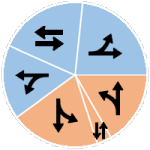
Example Bandera Rd. - Hausman Rd./Leslie Rd. signal timings
|
|
|
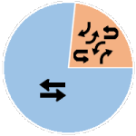
Previous (conventional)
|
RCUT*
|
|
Blue sections represent Bandera Rd. traffic * The orange slice in the RCUT used the largest orange slice from the conventional intersection and can be increased if needed. Read the fourth point in the explanation above for more details. |
|
|
For a deeper dive on how an RCUT functions and how it improves traffic flow, see the main Restricted Crossing U‑turn intersections page. |
** EARLY RESULTS **
Once the Leslie Rd./Hausman Rd. intersection was closed to cross traffic in early June 2024, positive results were seen immediately, with the typical morning inbound and afternoon outbound congestion on Bandera at that intersection evaporating overnight. Many observers attributed the congestion relief to the end of school (admittedly a fair assumption) with predictions that "things will be terrible" when school resumed in late August. However, after school started back up, the congestion did not return, and traffic flow was mostly smooth with the exception of numerous illegal U-turns being made at Cedar Trail. Additional signage was installed and enforcement efforts stepped-up.
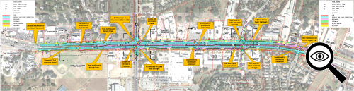
Perhaps the biggest early test of that intersection — and objective proof as to how well this design works — came on the afternoon of October 1st, 2024. Workers had the right lane of northbound Bandera closed at and just past Hausman Rd. until nearly 5:00 pm. This caused substantial congestion on both Bandera and Hausman (see Google Map image below.) (It's worth noting that this congestion was very similar to the afternoon congestion there prior to this project.) Within 15 minutes of the closure ending, the backup on Bandera was completely erased, and by 5:30 pm — the peak of rush hour, no less — the congestion on Hausman was also completely gone (see Google Map image below), thus demonstrating the substantial capacity and throughput these intersections provide. Prior to this project, that congestion would have persisted well into the evening.
|
5:00 pm 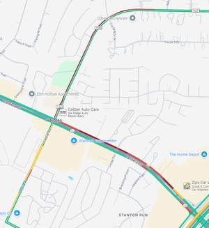
|
5:30 pm 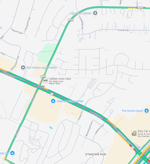
|
FAQ
- This looks confusing. It will cause lots of crashes.
This is always one of the first visceral assertions made when an unconventional intersection is introduced. With any change — even more conventional changes such as new signals or lanes — it naturally takes drivers a little time to adapt. With an RCUT, because all traffic on the intersecting street is forced to turn right, most confusion is quickly overcome instinctively once the driver has turned or as the driver follows other more experienced drivers through the intersection. Additionally, because all traffic is flowing in the same direction and is protected by signals, the likelihood of collisions is substantially reduced, even during the adjustment period. RCUTs also inherently improve safety by reducing conflict points (the point where vehicle paths cross) by half.
Statistics for RCUTs show improved safety. A study for the North Carolina DOT showed that RCUTs reduced traffic collisions by 46% and decreased injury crashes by 63%. A study of RCUT intersections in Missouri showed a 54% reduction in injury and fatal crashes. Many people predicted mayhem at the Bandera/1604 displaced left turn intersection, but, despite higher traffic volumes in 2021, the number of crashes was less than half of the number in 2017. - How does this crazy design improve traffic?
This intersection design improves traffic because, by forcing all traffic on the cross street to turn right, the green time for that can be overlapped with the green time for traffic turning left from Bandera onto the cross street. Since all traffic from the cross street turns right, this eliminates the green time needed for the through and left turn movements on the cross street which can then be reallocated to the remaining movements, thus moving more traffic through the intersection in the same amount of time. - How does adding even more traffic signals help?
Although this design adds more signals, they are all much more efficient because they only have to change twice per cycle instead of the four or five changes required at a traditional intersection. This means more traffic can get through the intersection in the same amount of time as a conventional intersection. And, because of this simplicity, the signals can also be much more easily coordinated. See the "How an RCUT works" section of the Restricted Crossing U‑turn intersections page for a deeper explanation of the RCUT "secret sauce." - All they have to do is adjust the signal timing and that will solve the problem.
It's a common belief that congestion can be solved by simply adjusting the signal timing. In some specific cases, that can be true, but at very busy intersections like Hausman and Bandera where there has to be sufficient green time for eight different movements on every cycle, the signals can only be optimized so much before the laws of physics win. For example, the green time on Hausman could be extended to help clear out the peak period backups that occur there, but that means the light will stay red longer for Bandera, which then increases the wait times and backups there. If the green time on Bandera is then increased to ease those backups, that means the light will stay red longer for Hausman and you're right back where you started. So as you can see, it's really not as easy as it sounds. - This causes people to have to go out of their way, which is inconvenient and will require more time to get across Bandera Rd.
Some folks understandably are peeved that to turn left or go straight from the cross street requires going out of one's way to accomplish. This is true and will always be perceived as an inconvenience by some drivers. While it is true that RCUTs can cause a slight increase in travel time for some movements during off-peak periods, the payoff comes periods of high traffic volumes where they have been shown to significantly decrease congestion and delays, reducing the time it takes to clear the intersection on all approaches, even when taking into account the additional distance required to use the turnaround. Also, keep in mind that there are many other examples where traffic wanting to make a left turn is prohibited from doing so due to a median, freeway, or one-way street and must therefore turn right first, then make a downstream U‑turn or series of left turns, so this situation is not unprecedented or unique to RCUTs. In fact, this was the case along much of this section of Bandera Rd. due to the existing median — for example, when leaving any of the businesses along Bandera between Hausman/Leslie and Cedar Trail, traffic had to turn right and then make a U-turn at the next intersection. - This benefits traffic on Bandera more than that on Hausman, Leslie, or Cedar Trail.
That's probably a fair assessment. Bandera Rd., after all, carries substantially more traffic than those other roads. But traffic on Hausman and Leslie still benefits. Those making a right turn onto Bandera see the most benefit, but even those turning left onto Bandera or crossing Bandera should still see some modest benefits due to overall reduction of wait times and congestion at the intersection and corresponding decreased travel times. Those same people almost certainly also use Bandera Rd. heading in other directions at some other point in their daily lives, so they'll realize those benefits as well. - This will increase emergency response times in the area.
TxDOT worked with the City of Helotes to mitigate concerns with response times. As a result, some adjustments to the plans were made to better accommodate emergency vehicles. Again, it's worth noting that most of this stretch of Bandera today did not previously have intermediate crossovers, so in some cases, emergency vehicles will actually have faster access than before. - Why are there signals to leave the turnarounds?
This is to prevent the significantly slower-moving vehicles making that U‑turn from entering the faster traffic stream and causing conflicts that could result in collisions or congestion. Accordingly, a left turn on red will not be allowed at those signals. - Am I able to make a right turn on red?
To turn from Bandera onto Hausman, Leslie, or Cedar Trail, there are channelized right-turn lanes with a yield sign, so traffic turning right is no longer controlled by the signal and simply has to yield when turning.
On Hausman, Leslie, and Cedar Trail, a right-on-red onto Bandera is only be allowed from the rightmost lane; the other lane(s) are not be allowed to turn right on red. This is primarily for both safety reasons.
At Legend Trail, traffic turning from Bandera onto Legend Trail is allowed to turn right on red, but traffic turning onto Bandera from Legend Trail not be allowed to do so. - If I'm headed south on FM 1560 (Hausman Rd.) and want to go to Wal-Mart, Starbucks, Bill Miller's, Kuentz ES, or O'Connor HS, or to head southbound on Bandera Rd., how do I get there?
At Bandera Rd., turn right, travel about 1,000 feet to the turnaround (just past Little Caesar's Pizza), make a U-turn, then head southbound on Bandera where you can turn right at Bill Miller's, Leslie Rd. (for the schools), Starbucks, or Wal-Mart, or continue straight on southbound Bandera. To return to Hausman Rd. from Bill Miller's, Kuentz, O'Connor, Starbucks, or Wal-Mart, turn right onto Bandera Rd. and use the turnaround just past Wal-Mart to return to Hausman Rd., which, in several of those scenarios, is actually more convenient than what was there previously. - Why not build overpasses instead?
Across the country, traffic engineers have discovered that innovative intersections like this can produce good congestion relief and safety at a fraction of the cost, disruption, construction time, and aesthetic impact of flyovers and other traditional grade-separated solutions. This allows limited transportation dollars to be saved and used for other needed projects.
The current and future traffic volumes and safety considerations along Bandera Rd. aren't sufficient to justify the construction of overpasses or conversion to a freeway, but they are in the "sweet spot" to support RCUTs. Furthermore, the right-of-way along Bandera Rd. is not wide enough for overpasses or a freeway, so the cost would be considerably higher as additional right-of-way would have to be obtained, which likely would result in the displacement of many businesses. - How do pedestrians cross Bandera Rd.?
There are signalized crossings to cross Bandera at Hausman/Leslie and at Cedar Trail. These new crossings should be a bit safer than the previous intersections because pedestrians will cross Bandera Rd. in four relatively short stages with refuge islands in between rather than the one long crossing that was there before. There are also signalized crossings to cross Hausman, Leslie, and Cedar Trail just as there were previously. A signalized crossing is also available to cross Legend Trail, but not to cross Bandera at that location. - Why don't they build a pedestrian overpass for students to cross Bandera Rd. at Hausman/Leslie?
Many people instinctively assume that pedestrian overpasses are inherently safer than signalized crossings, but studies have shown that not to be the case. And, studies have shown that most people will still cross a road at-grade even when a pedestrian overpass is available. Pedestrian bridges are really a last resort and typically only needed to cross roadways such as freeways.
Furthermore, there's not enough room at that intersection for a pedestrian bridge due to the length of the ramps that are required to be ADA compliant. The length of those ramps, by the way, is why most people will cross the road directly rather than using the overpass. - Will the Circle A Trail intersection be changed to allow left turns again?
No, that intersection is outside the scope of this project, although TxDOT did re-evaluate this intersection when planning this project; see the discussion of this in the "Circle A Trail intersection" section above. - Are there any other RCUTs in San Antonio?
Yes, there have been two other RCUT segments in San Antonio. One was on US 281 north of Loop 1604 and the other was nearby on Loop 1604 between Braun Rd. and Culebra Rd. Both were built as short-term solutions while approval and funding for freeway expansions was obtained. As intended, the Loop 1604 RCUT was replaced by a freeway in 2016, and the US 281 RCUT was replaced by a freeway in 2021. Unlike the 281 and 1604 RCUTs, which were built as short-term fixes, the RCUTs in Helotes are considered a long-term solution. RCUTs are now also proposed for Bandera Rd. inside Loop 1604 and for Loop 1604 from US 90 to Macdona Lacoste Rd., and have been constructed on a segment of Loop 337 in New Braunfels. - I heard that the US 281 "superstreet" was removed because it was not working well, so why build one here?
That is false. There had always been plans going back to 2000 to upgrade US 281 in that area to a freeway. However, multiple lawsuits by anti-toll activists and environmentalists, and a resulting requirement to conduct a lengthly environmental study, delayed the project for nearly two decades. In 2009, with congestion reaching severe levels, the "superstreet" (aka RCUT intersections) was proposed as a short-term "band-aid" to help provide some relief, which it did until construction on the freeway was finally able to get started in 2017. The expected future traffic volumes on US 281 exceed what RCUTs can optimally handle, so that would never have been planned as a permanent solution there. However, the current and projected traffic volumes on Bandera Rd. are in the "sweet spot" for RCUTs to have a significant long-term positive impact. For comparison, traffic volumes on the section of US 281 with the RCUTs ranged from 55,000 at Marshall Rd. to 100,000 at Redland Rd., while on Bandera they range from 23,000 just west of FM 1560 South to 43,000 at Loop 1604. - Who came up with this cockamamie design? This won't work and is just a waste of money.
The RCUT design and variations have been used in several US states for more than 20 years and has a proven track record of improving traffic wherever it has been implemented. Both the US 281 and Loop 1604 RCUTs showed appreciable improvements, and computer modeling shows that these RCUTs will do the same. An RCUT is one of several types of "innovative" or "alternative" intersection designs being implemented across the country at intersections where benefits from conventional intersection improvements would be short-lived but where conditions do not warrant more expensive traditional upgrades such as overpasses. Many people expressed similar skepticism about the nearby Bandera/1604 displaced left turn (DLT) intersection, but the new design has substantially reduced congestion and crashes there.
Schematic
Click on the image below to open the detailed schematic for this project from TxDOT with my own annotations added to help clarify and explain the various elements. The schematic will open in a new window that you can scroll and zoom.
Video
TxDOT has a good video that describes this project:
Other sites of interest
|
|
TxDOT - Virtual Public Meeting - SH 16 Helotes https://www.txdot.gov/projects/ |
|
|
Pape-Dawson "Superstreets in Texas" presentation https://drive.google.com/ |
|
|
NC Department of Transportation presentation on superstreets (Excellent explanation of all aspects of superstreets) https://www.partnc.org/ |
|
|
Wikipedia - Superstreet https://en.wikipedia.org/wiki/ |
|
|
Virginia Department of Transportation - Restricted Crossing U‑turn https://www.vdot.virginia.gov/ |
|
|
Federal Highway Administration - Restricted Crossing U‑turn Intersection Informational Guide https://safety.fhwa.dot.gov/ |
|
|
An Update on Superstreet Implementation and Research http://www.teachamerica.com/ |