|
||
|
|
||
This page last updated February 8, 2025 |


|
The proposals on this page are still in development The cities of San Antonio and Leon Valley and the Texas Department of Transportation are currently in the midst of a years-long study to determine how to improve this section of Bandera Rd. As a result, the details discussed below are subject to change. |
|
Looking for information on the RCUTs project in Helotes? See the Bandera Rd. RCUTs Helotes project page. |
Bandera Road (SH 16) between Loops 410 and 1604 in Leon Valley and Northwest San Antonio is one of the most congested roads in the region. About 70,000 vehicles a day use the southern half of the route, and about 40,000 use the northern half. To put that into perspective, the section of Loop 410 on the South Side between I‑35 and I‑37 carries about 50,000 vehicles per day, and the stretch of Loop 1604 between SH 151 and US 90 carries less than 40,000 vehicles per day. So improvements to Bandera Road are urgently needed and have been for decades, but the road has languished with only a few minor improvements since the mid '80s.
The problem hasn't been that officials haven't recognized this need; a freeway was actually planned for Bandera Rd. during the 1950s and 60s, and more recently, there have been at least seven studies and proposals to upgrade Bandera Rd. over the past three decades. The biggest snag has been finding improvements that are amenable to the City of Leon Valley. A flyover proposal by TxDOT back around 1990 was shot down by Leon Valley leaders, and an alternative plan that proposed building an elevated highway along Leon Creek and bypassing Leon Valley altogether also was nixed for other reasons. This schism has resulted in the repeated stalling of efforts to make major improvements to Bandera Rd.
In 2009, the Alamo Area Regional Mobility Authority (ARMA) included Bandera Rd. in their regional toll system plan. The conceptual proposal was an elevated tollway along the length of Bandera between the loops. However, subsequent feasibility studies — and simmering opposition from several constituencies — scuttled that plan. TxDOT subsequently took over studying other options to relieve congestion in the corridor.
|
ADVERTISEMENT |
On this page:
Current planning
As discussed above, various agencies have been studying a number of options to reduce congestion and improve safety on Bandera Rd. for many years. In 2018, the City of San Antonio joined those ongoing Bandera Rd. planning efforts and launched a "community planning process" to develop a overarching plan for transportation, land use, urban design, and economic development along Bandera Rd. The first public meeting in this combined planning effort was held April 29th, 2019, with additional meetings held in December 2019, June 2021, October 2022, and February 2025.
- Through traffic: Current studies indicate that about 9-15% of traffic on Bandera travels from Loop 410 to Loop 1604 or vice versa. However, with continuing growth along Bandera outside Loop 1604, it is expected that percentage will increase.
- Local traffic: This is traffic with origins and/or destinations in the Bandera Road corridor (i.e. local residents and/or patrons of local businesses).
- Cross traffic: This consists of traffic using a portion of Bandera for cross connectivity between the staggered thoroughfares on each side of Bandera. Analysis of traffic data revealed that there the three most significant movements in this category are:
- Eckhert Rd. ↔ Mainland Rd./Guilbeau Rd.
- Loop 410 ↔ Grissom Rd.
- Loop 1604 ↔ Prue Rd.
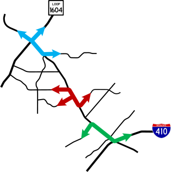
These cross-traffic movements create two unique problems:
- They inject a large amount of traffic onto Bandera for a short distance.
- They generate massive left turn movements at multiple intersections. Left turns are the most inefficient traffic movement and require substantially more signal time, which then reduces the amount of signal time available for the other movements.
The traffic study also looked at projected traffic volumes through the year 2047, which showed increases of around 40% south of Braun to over 85% north of there.
- Conventional widening: This plan would add one lane in each direction to the existing lanes (i.e. eight lanes from the Loop 410 ramps to Guilbeau and six lanes from there to Loop 1604), make conventional intersection improvements, and improve access management (i.e. limiting driveways).
- RCUT: This would convert all intersections in the corridor to "Restricted Crossing U-Turn" (RCUT) intersections. Additional through lanes could also be included in this plan. This option is discussed in more detail below.
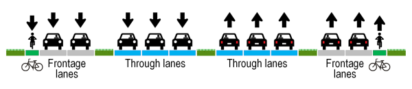
- Boulevard: This concept would add a two-lane frontage road on each side of the existing roadway, which would be rebuilt. This option is discussed in more detail below.
- Thoroughfare network improvements: TxDOT identified and modeled several possible arterial connections on either side of Bandera that could remove much of the cross-traffic. Of the options explored, a connector from Eckhert at Abe Lincoln to Bandera at Mainland and/or Guilbeau had the most promise. The City of San Antonio has agreed to study this further and would be responsible for building it should it be determined to be feasible.
- Reversible connector: This concept would build an elevated, reversible roadway to provide a direct express lane for one or more of the cross-traffic movements. It would be reversible, meaning it would change direction between the morning and afternoon rush hours to flow in the direction of peak traffic.
- Traditional freeway: This would build a standard freeway corridor with mainlanes, overpasses, ramps, and access roads.
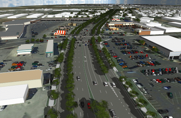
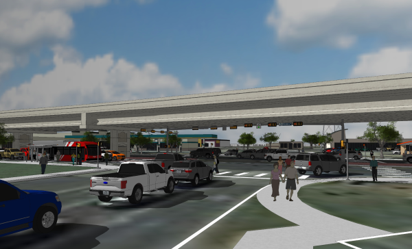
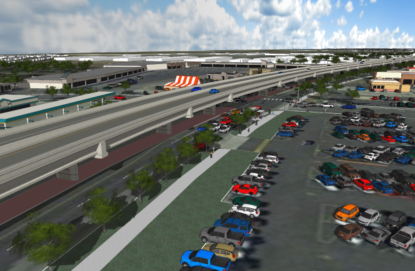
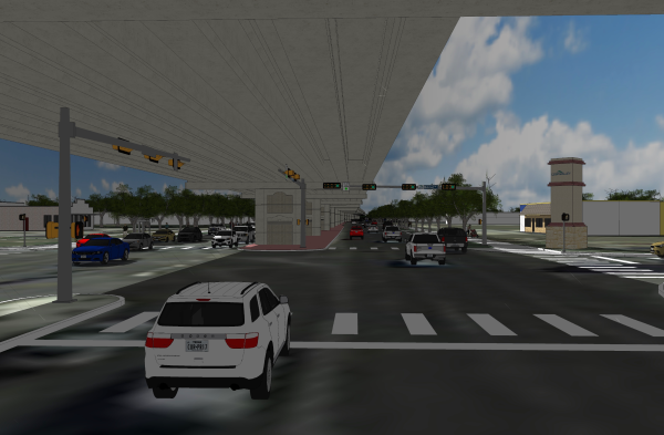
- Elevated throughway: This proposal, commonly-referred to as the "flyover" plan, would consist of building an elevated roadway on piers located in the center median. This elevated roadway, running from Loop 410 to Loop 1604, would cantilever over the surface lanes and consist of a single lane and a shoulder in each direction to carry through traffic, similar to the existing flyovers connecting Bandera and Loop 410, to which they would connect. Due to right-of-way constraints that limit possible "touch-down" locations for entrance and exit ramps, access points along the elevated section would be very limited. Although this was included as a possibility in a previous toll road plan, this option would not be tolled.
After the initial study, the options were winnowed down and refined to four:
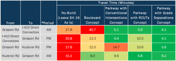
- Conventional widening and intersection improvements: This would widen Bandera to four lanes each way, add additional turn lanes at intersections, and eliminate the "split phasing" of the traffic signals at many of the intersections that allows only one direction of the cross street to have a green signal at a time. This option provided the second lowest reduction in congestion reduction, meeting only 62-66% of 2047 projected demand, mostly due to the remaining inherent inefficiencies of the intersections.
- Boulevard: This option is discussed in more detail below. Of the four options studied, this provided the least reduction in congestion, meeting only 57-64% of 2047 projected demand (again, mostly due to remaining inherent inefficiencies at the intersections), increased intersection conflicts because of the addition of frontage roads, and required the the most additional right-of-way.
- RCUT: This option is discussed in more detail below. It provided good congestion reduction, meeting 84% of projected 2047 demand.
- RCUT with grade separations: This would combine both the RCUT option along the entire corridor and the "flyover" plan from the Loop 410 connectors to Guilbeau. However, the flyover lanes would instead descend below ground level through Leon Valley to minimize the visual impact. This option had the best reduction of congestion, meeting 90-93% of projected 2047 demand. However, it was also by far the most expensive at $410 million, had the longest construction duration and impact, and had the most long-term maintenance costs, mostly due to the depressed segment needing stormwater pumping, air ventilation, and fire protection.
TxDOT branded all the options except the boulevard as "parkway" options, meaning that in addition to expansion, efforts would be made to beautify the corridor. (The boulevard proposal would also include beautification efforts, although they would be more limited than the other options due to the tight right-of-way.) All the options would also consolidate driveways and median crossovers.
With that decision, the next steps will be to finalize formal buy-in from the stakeholders, then move to advanced design and planning, environmental study and clearance, and final engineering. At the same time, efforts will be made to identify funding as there is currently none earmarked for this project. If all goes perfectly, construction could begin around 2024 and be complete around 2027, but it's more likely to be a couple or few years beyond that.
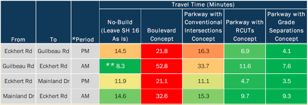
** The good No-build travel time on the Guilbeau Road to Eckhert Road (AM) segment is due to bottlenecking north of Guilbeau Road, which limits the volume of traffic that can reach this segment of SH 16 in the AM peak period, thus reducing congestion there.
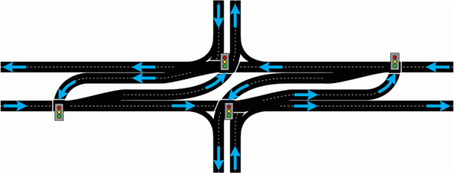
RCUT proposal
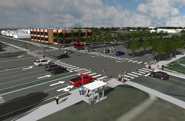
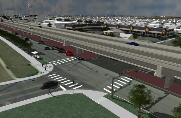
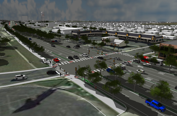
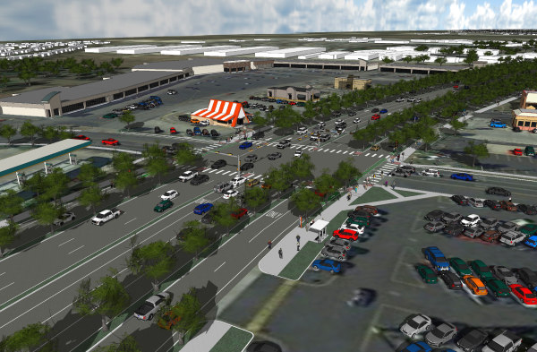
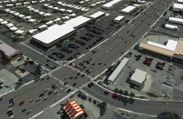
Of the four options studied, the RCUT concept was selected in 2022 as the preferred option to carry forward. This would convert the nearly all of the signalized intersections on Bandera Rd. to Restricted Crossing U-Turn (RCUT) intersections, add signalized turnarounds at multiple intermediate locations, close all of the unsignalized crossovers, and eliminate the signalized intersections at Reindeer Trail and Poss Rd. — they would become "right-in, right-out" intersections.
This plan would also widen Bandera to four lanes in each direction, consolidate many of the driveways along the corridor, add a shared pedestrian/bicycle path on both sides as well as other pedestrian/bike improvements, and add curbs and underground storm drains.
The RCUT intersections will prevent traffic on the intersecting roads from going straight or turning left. Instead, all traffic will make a right turn, then use a signalized turnaround typically 1000 or so feet downstream to make a U-turn and continue in the intended direction of travel. Left turns from Bandera Rd. to those cross streets will still be allowed.
An RCUT intersection is also known as a "superstreet" or a "J-turn".

|
If all of that sounds like technical gibberish, here's another way of explaining it: At a traditional intersection, drivers who arrive as the light turns red have to wait for three or four other directions to get a green light before their light turns green again. At an RCUT intersection, drivers only have to wait for one signal change before they get a green again. Drivers then needing to use the turnaround may have to subsequently wait for one more signal change, but that's still less than before. |
Additionally, with an RCUT, each half of the intersection operates independently of the other, so the signals along each direction of Bandera Rd. can be timed separately from the other direction, which means better coordination and synchronization are possible.
Modeling showed that this configuration is expected to provide good long-term congestion relief based on 25-year traffic projections. While traffic may still slow during peak periods, it should still move better than it does now, and notably, the corridor should experience little to no congestion outside of the peak periods when it often does today.
RCUTs have also been proven to improve safety. A study for the North Carolina DOT showed that RCUTs reduced traffic collisions by 46% and decreased crashes with injuries by 63%. A study of RCUT intersections in Missouri showed a 54% reduction in injury and fatal crashes. Many people predicted mayhem at the Bandera/1604 displaced left turn intersection, but, despite higher traffic volumes in 2021, the number of crashes was less than half of the number in 2017.
Example signal timings
|
|
|
Current
|
RCUT
|
|
Blue sections represent Bandera Rd. traffic |
|
|
|
For a deeper dive on how an RCUT functions and how it improves traffic flow, see the main Restricted Crossing U‑turn intersections page. |
NOTE: This is the 2025 schematic.
Flyover and boulevard proposals
(Note that both the flyover and boulevard proposals discussed below were dropped from consideration. They are included here for background.)
As with previous flyover proposals over the years, the most recent flyover proposals generated controversy in Leon Valley. Chief among the concerns of many leaders and residents there is that a flyover would speed traffic through the suburb and, it is asserted, would speed drivers past the businesses along Bandera, thus negatively affecting them. These businesses, of course, comprise an outsized portion of that city's tax base, so their concern is understandable. (Of course, congestion also negatively impacts those businesses, perhaps even more than a flyover would. Research shows a 10% reduction in average travel speeds in a corridor can result in a 20% loss of market area for nearby businesses.)
Additionally, there was great concern about the aesthetics of an elevated road, specifically that it would be unsightly and create a visual barrier that would divide the city and negatively impact property values. There was also angst about the noise that an elevated road would generate.
After researching other concepts, they developed a proposal for what is known as a "multi-way boulevard." As envisioned, this would be a 10 lane at-grade thoroughfare with signalized intersections in the same locations as today. The 10 lanes would include three main through lanes in each direction with two parallel frontage lanes on each side. The frontage lanes would be built in the area used today for the drainage culverts on the side of the road and would be physically separated from the through lanes by landscaped traffic islands. Just like the frontage roads along a freeway, the frontage lanes in this concept would provide access to adjacent properties, and would be the location for sidewalks, bus stops, and bike lanes. Traffic would move between the through lanes and frontage lanes via slip ramps located between intersections, just like smaller versions of the entrance and exit ramps from access roads to freeways.
The report listed the expected benefits of the boulevard concept as follows:
- By isolating slower local traffic to the frontage lanes, traffic in the through lanes can move faster and more safely.
- With 10 lanes, the corridor would have about 66% more lane capacity than today.
- The boulevard would be landscaped with trees and other foliage, making the corridor more pleasant and inviting especially for pedestrians and cyclists.
- Because there are no elevated structures, a boulevard would be much less obtrusive than an elevated highway, thus minimizing visual and sound impacts.
While the flyover proposal would require about 11 acres of additional right-of-way, the boulevard proposal would require about 30 acres of additional right-of-way.
(COMMENTARY: I get that there wasn't an easy way to determine this, but that seems to be an overly simplistic inference as there are many other variables and factors that would likely have played into the increased property values. To be fair, it would require much more extensive study to identify and control for those factors. But it is also well-known that improved access typically leads to an increase in property values. Furthermore, my own cursory analysis of several random properties in the shadow of the current flyover in the vicinity of Bandera and Wurzbach show that almost all of them increased in value over a five year window at roughly the same rate as other properties further down Bandera in Leon Valley. Again, to be fair, I was not able to compare the property values immediately before and after the flyovers were built nor do an extensive analysis. In closing, normally I would present the study's findings without editorial, but I felt these points needed to made. Reasonable people can disagree on this, and your mileage may vary.)
There is also evidence that increasing the walkability of an area increases adjacent property values.
A sincere thank you goes to the UTSA Center for Urban and Regional Planning Research and the City of Leon Valley for making these available.
FAQ
Below are some frequently-asked questions and comments about this corridor.
- RCUTs look confusing. They will cause lots of crashes.
This is always one of the first visceral assertions made when an unconventional intersection is introduced. With any change — even more conventional changes such as new signals or lanes — it naturally takes drivers a little time to adapt. With an RCUT, because all traffic on the intersecting street is forced to turn right, most confusion is quickly overcome instinctively once the driver has turned or as the driver follows other more experienced drivers through the intersection. Additionally, because all traffic is flowing in the same direction and is protected by signals, the likelihood of collisions is substantially reduced, even during the adjustment period. RCUTs also inherently improve safety by reducing conflict points (the point where vehicle paths cross) by half.
Statistics for RCUTs show improved safety. A study for the North Carolina DOT showed that RCUTs reduced traffic collisions by 46% and decreased injury crashes by 63%. A study of RCUT intersections in Missouri showed a 54% reduction in injury and fatal crashes. Many people predicted mayhem at the Bandera/1604 displaced left turn intersection, but, despite higher traffic volumes in 2021, the number of crashes was less than half of the number in 2017. - How does this crazy design (RCUTs) improve traffic? How does adding even more traffic signals help?
This intersection design improves traffic because, by forcing all traffic on the cross street to turn right, the green time for that can be overlapped with the green time for traffic turning left from Bandera onto the cross street. This essentially eliminates the green time that would be needed for the through and left turn movements on the cross street, so that time can then be reallocated to the remaining movements, thus moving more traffic through the intersection in the same amount of time. Although there are extra signals, they are all much more efficient and are better coordinated. See the "How an RCUT works" section of the Restricted Crossing U‑turn intersections page for a deeper explanation of the RCUT "secret sauce." - This causes people to have to go out of their way, which is inconvenient and will require more time to get across Bandera Rd.
Some folks understandably are peeved that to turn left or go straight from the cross street requires going out of one's way to accomplish. This is true and will always be perceived as an inconvenience by some drivers. While it is true that RCUTs can cause a slight increase in travel time for some movements during off-peak periods, the payoff comes periods of high traffic volumes where they have been shown to significantly decrease congestion and delays, reducing the time it takes to clear the intersection on all approaches, even when taking into account the additional distance required to use the turnaround. Also, keep in mind that there are many other examples where traffic wanting to make a left turn is prohibited from doing so due to a median, freeway, or one-way street and must therefore turn right first, then make a downstream U‑turn or series of left turns, so this situation is not unprecedented or unique to RCUTs. In fact, this has already been the case along much of this section of Bandera Rd. due to the existing median — for example, when leaving most of the businesses along there. - This will increase emergency response times in the area.
TxDOT will work with the City of Leon Valley to mitigate concerns with response times. The initial proposal includes a special traversable median and actuated traffic signals for emergency vehicles at El Verde. - Why not build overpasses instead?
Various flyover plans have been proposed over the years, but the City of Leon Valley has been and continues to be opposed to such plans due to various economic and aesthetic concerns. Therefore, engineers have had to look at alternatives. Across the country, traffic engineers have discovered that innovative intersections like RCUTs can produce good congestion relief and safety at a fraction of the cost and construction time of flyovers and other traditional grade-separated solutions. - Why are there signals to leave the turnarounds?
This is to prevent the significantly slower-moving vehicles making that U‑turn from entering the faster traffic stream and causing conflicts that could result in collisions or congestion. - Are there any other RCUTs in San Antonio?
Yes, there have been two other RCUT segments in San Antonio. One was on US 281 north of Loop 1604 and the other was nearby on Loop 1604 between Braun Rd. and Culebra Rd. Both were built as short-term solutions while approval and funding for freeway expansions was obtained. As intended, the Loop 1604 RCUT was replaced by a freeway in 2016, and the US 281 RCUT was replaced by a freeway in 2021.
An RCUT intersection was built at Bandera at FM 1560 South in Helotes in 2018, and two more RCUT intersections are under construction in Helotes. Unlike the 281 and 1604 RCUTs, which were built as short-term fixes, the RCUTs in Helotes are considered a long-term solution.
RCUTS have also been constructed on a segment of Loop 337 in New Braunfels, and they are planned for Loop 1604 from US 90 to Macdona Lacoste Rd. - I heard that the US 281 "superstreet" was removed because it was not working well, so why build one here?
That is false. There had always been plans going back to 2000 to upgrade US 281 in that area to a freeway. However, multiple lawsuits by anti-toll activists and environmentalists, and a resulting requirement to conduct a lengthly environmental study, delayed the project for nearly two decades. In 2009, with congestion reaching severe levels, the "superstreet" (aka RCUT intersections) was proposed as a short-term "band-aid" to help provide some relief, which it did until construction on the freeway was finally able to get started in 2017. The expected future traffic volumes on US 281 exceed what RCUTs can optimally handle, so that would never have been planned as a permanent solution there. However, the current and projected traffic volumes on Bandera Rd. are in the "sweet spot" for RCUTs to have a significant long-term positive impact. For comparison, traffic volumes on the section of US 281 with the RCUTs ranged from 55,000 at Marshall Rd. to 100,000 at Redland Rd., while on Bandera they range from 23,000 just west of FM 1560 South to 43,000 at Loop 1604. - Who came up with this cockamamie design? This won't work and is just a waste of money.
The RCUT design and variations have been used in several US states for more than 20 years and has a proven track record of improving traffic wherever it has been implemented. Both the US 281 and Loop 1604 RCUTs showed appreciable improvements, and computer modeling shows that these RCUTs will do the same. An RCUT is one of several types of "innovative" or "alternative" intersection designs being implemented across the country at intersections where benefits from conventional intersection improvements would be short-lived but where conditions do not warrant more expensive traditional upgrades such as overpasses. Many people expressed similar skepticism about the nearby Bandera/1604 displaced left turn (DLT) intersection, but the new design has substantially reduced congestion and crashes there. - Why can't they just synchronize the traffic signals on Bandera? This would fix the problem.
Actually, the signals on Bandera are already part of a coordinated system and are optimized. Many people think that just synchronizing (coordinating) signals is a magic solution to all congestion. While in many situations it can and does provide substantial benefits, the fact is that coordinated signals can only provide improvements up to the point where traffic volumes on a road reach the saturation point, and then the laws of physics (space and time) take over. Bandera Rd. well exceeds the saturation level at many times of the day. Here's a video I made showing the synchronization on Bandera Rd. and one reason it breaks down.
That video illustrates a basic reason why "just synchronizing the lights" on Bandera isn't the easy fix it's often thought to be. Another problem that is especially prevalent on Bandera Rd. is that there is a heavy volume of traffic that turns onto Bandera from the intersecting roadways. This traffic fills the breaks in the through traffic that is used to give green time for cross traffic on the downstream intersecting roads. In doing so, these "interlopers" essentially take the green time that was intended for the next group of through vehicles (known as a "platoon"), resulting in part or even all of that platoon getting stopped, making it seem like the signals aren't synchronized. With each cycle, the process repeats and the problems compound.
This shows the limitations of signal coordination. When this situation happens, the traditional solution is to upgrade the corridor to a freeway. However, a freeway is not politically-tenable on this corridor and would require significant new right-of-way. Thus, non-conventional solutions are needed.
For some other reasons signal synchronization may not appear to be working, see the answer to "Why aren't traffic signals in San Antonio synchronized?" on the San Antonio roads FAQ page. - Why did they build the flyovers at Loop 410? They don't really help and were a waste of money.
As is often the case, this perspective ignores the bigger picture. The flyovers at Loop 410 take the heaviest traffic movement at that location and remove it from two already-congested signalized intersections. While traffic coming from Loop 410 to Bandera regularly backs-up during the afternoon rush hour, it does so up and out of the way of the surface intersections. More importantly, before the flyovers were built, that traffic nearly always backed-up from the exit ramp and onto the Loop 410 mainlanes, which was a dangerous situation. Now, that traffic is stored safely out of the way. Meanwhile, traffic headed the other way enjoys a good five minutes or more of time savings during the morning rush hour. When Bandera Rd. through Leon Valley is eventually improved, commuters going from Loop 410 to Bandera Rd. during the afternoon rush hour will enjoy the full potential benefits of the existing flyover. While congestion at that location may make it seem like the flyovers don't help, the point that's often forgotten is this: How much worse would the congestion there be without the flyovers? - The existing flyovers caused several nearby businesses to go under.
The author of this site is only aware of one business that claimed it was harmed by the flyovers. Regardless, there is no objective data to support that claim. It could have been a case of that business already having difficulties that were exacerbated by the traffic changes, or, perhaps, the flyovers are being used as a scapegoat. The other established businesses in the area seem to be doing fine. Regardless, congestion is at least equally detrimental to businesses if not more so, so improvements need to be made. While nobody wants to see businesses fail, there will, unfortunately, always be trade-offs whenever a major change is made, and attempts are made to minimize those impacts. - Traffic has been bad on Bandera for decades — why hasn't anything been done?
As mentioned above, several attempts have been made over the years to improve Bandera Rd., including adding flyovers at major intersections and an elevated tollway, but the City of Leon Valley vetoed most of the proposals, ostensibly due to fears that those plans would hurt local businesses, which in turn would have a serious impact on the city. New leadership in Leon Valley in recent years has recognized the need for improvements and has indicated a willingness to find solutions, but there's still a long road ahead (pun intended). A new comprehensive planning effort that includes TxDOT and the cities of Leon Valley and San Antonio has been underway for several years with all parties now agreeing on the preferred solution.
Acknowledgments
Special thanks to the following for their assistance in providing information about these proposals:
- UTSA Center for Urban and Regional Planning Research
- City of Leon Valley
- Texas Department of Transportation
Other sites of interest
|
|
City of San Antonio - Bandera Road Corridor Plan https://www.sanantonio.gov/ |
|
|
TxDOT - SH 16 (Bandera Road) from I‑410 to Loop 1604 https://www.txdot.gov/ |