|
||
|
|
||
This page last updated November 8, 2025 |

|
|
|
|
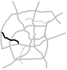
This page covers Texas State Highway (SH) 151 from US‑90 to Loop 1604 in western San Antonio. Length: 10 miles |
|
ADVERTISEMENT |
On this page:


Overview
SH 151 connects rapidly-growing far western Bexar County to Loop 410 and to downtown via US‑90. It is the main corridor through the Westover Hills area, which includes Sea World of Texas, the Hyatt Hill Country Resort, several major financial services companies, a National Security Agency campus, multiple large data centers, and Northwest Vista College. This route also serves the Southwest Research Institute and Texas Biomedical Research Institute. At the western end of the corridor is the sprawling Alamo Ranch development. Residential and commercial construction is booming in the corridor with major retail hubs at Loop 410 and Loop 1604.
Inside Loop 410, the majority of the land fronting the corridor is undeveloped, although the area near US‑90 has seen growing light to moderate industrial development, primarily warehouses. Outside of 410, much of the frontage is now a mix of suburban commercial and residential.
Roadway details
| LANES | |
|
|
|
|
| ACCESS ROADS |
|
| EXITS |
Click here for a list of SH 151 exits. |
| SPEED LIMITS | |
|
|

| AVERAGE DAILY TRAFFIC | |||||||
| LOCATION | 2002 | 2012 | 2017 | 2019 | 2021 | 2022 | '12-'22 % CHG |
| N of US‑90 | 36,000 | 60,000 | 73,640 | 86,656 | 84,625 | 75,946 | +26.58% |
| E of Callaghan Rd. | 79,202 | 72,917 | N/A | ||||
| E of Loop 410 | 21,000 | 65,000 | 71,659 | 82,678 | 79,979 | 74,005 | +13.85% |
| E of Potranco Rd. | 40,000 | 95,000 | 109,928 | 120,807 | 127,629 | 140,491 | +47.89% |
| W of Potranco Rd. | 31,000 | 85,000 | N/A | ||||
| W of Hunt Ln. | 78,000 | 93,988 | 105,118 | 106,950 | 114,247 | +46.47% | |
| E of Loop 1604 | 11,300 | 45,000 | 60,521 | 67,705 | 79,091 | 83,472 | +85.49% |
(NOTE: In 2021, TxDOT changed the location of several traffic counting stations. New stations will show no history prior to 2021.)
|
ADVERTISEMENT |
Media gallery
Click here for historical photos of this freeway.
Click here for video of this freeway.
Construction projects
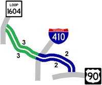
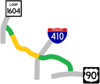
- Loop 410 to Loop 1604: This project is widening the freeway from four to six lanes and building a new connector to northbound Loop 1604. Click here for more information on this project.
Click here to view information for all projects in this corridor.
Future plans
A plan to to extend SH 151 all the way to SH 211 in far western Bexar County was once envisioned as part of the now-cancelled regional tollway system. However, regional thoroughfare plans do still show Alamo Ranch Parkway — which is a county road — eventually connecting to SH 211, although there are currently no plans to extend SH 151 itself over that route.
A future project will add the remaining flyovers at Loop 410, but there is currently no timeline for that.
A study is underway for possibly long-term improvements to Loop 1604 that could include additional direct connectors in the 151/1604 interchange.
History
SH 151 is authorized by Minute Order 81732 (March 14, 1984). The route is named for Raymond Stotzer Jr., a longtime TxDOT engineer and the head of the San Antonio TxDOT district from 1974 to 1986 who was instrumental in getting the route approved. It originally had the moniker "West Side Expressway." When it was first proposed, some maps mistakenly labeled the route as the "Northwest Expressway", but at the time, I‑10 northwest of downtown officially held that name. (I‑10 was subsequently renamed the "McDermott Freeway" in the mid '90s.)
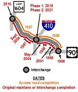
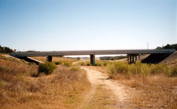
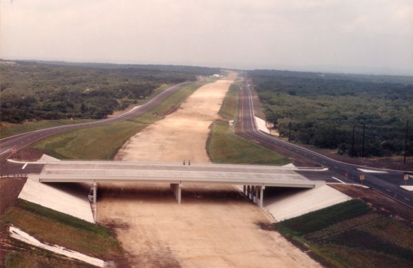
Like many freeways in Texas, the access roads were built first, then the mainlanes followed as traffic necessitated. On SH 151, the mainlanes were built in piecemeal fashion as traffic warranted and funding was available with short sections of freeway and overpasses at major intersections first, followed finally by the remainder of the mainlanes.
- 1983: Local real estate developer Marty Wender, noting that the fast-growing Northwest Side was the largest gap in the freeway system — and himself needing access to his planned Westover Hills development — pitched the idea of a freeway connecting Loop 1604 to US‑90. To help improve the chances of approval and expedite its construction, he coordinated the donation of 85% of the right-of-way and also donated funding to cover half the cost of the access roads.
- 1984: Texas Transportation Commission approves SH 151.
- 1985: SeaWorld announces they will build a park in Westover Hills. Construction of the frontage roads between Loop 410 and Loop 1604 begins including the overpasses over the future mainlanes at Military Dr., Westover Hills Blvd., and Wiseman Blvd.
- 1986: Construction of the access roads between Loop 410 and US‑90 begins.
- 1987: Access roads between Loop 410 and Loop 1604 opened.
- 1988: Access roads between Loop 410 and US‑90 completed as well as the interchange at US‑90.
- May 1988: SeaWorld opens.
- 1997: Construction completed on the first short segment of freeway mainlanes over Ingram Rd. and Potranco Rd.
- February 1998: Freeway mainlane overpass at Old Highway 90 opened.
- Summer 1998: Freeway mainlane overpass at Pinn Rd. completed.
- March 2001: Mainlanes between Callaghan Rd. and Old Highway 90 — including the overpass at Callaghan Rd. — completed.
- 2003: Modifications to the 151/1604 interchange made in conjunction with the Loop 1604/Culebra overpass project. As a result of a statewide directive, a study was initiated to determine the feasibility of tolling the new SH 151 mainlanes. However, due to local political pressure — and notably the fact that most of the right-of-way for SH 151 had been donated — the tollway proposal was subsequently dropped.
- May 2004: Mainlanes from Callaghan Rd. to Loop 410 completed.
- September 2004: Mainlanes from Loop 410 to Loop 1604 opened.
- July 2016: Flyover from southbound Loop 1604 to SH 151 completed.
- December 2016: Overpass from SH 151 to Alamo Ranch Parkway opened.
- 2018: Flyovers from southbound Loop 410 to SH 151 westbound and from eastbound SH 151 to Loop 410 northbound opened in April and May respectively.
- 2021: Flyovers from eastbound SH 151 to southbound Loop 410 and northbound Loop 410 to westbound SH 151 opened in September and October respectively.
|
More historical photos of SH 151 are available here. |