|
||
|
|
||
This page last updated February 5, 2024 |

|
|
|
|
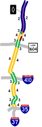
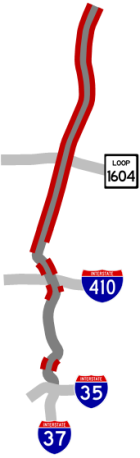
This page covers US 281 north of downtown San Antonio from the I‑35 interchange to the Comal county line. US 281 continues south of downtown concurrent (multiplexed) with I‑37. Length: 21 miles |
|
ADVERTISEMENT |
On this page:


Overview
This freeway is the spine for San Antonio's rapidly-growing North-Central area. The route serves The Pearl, Brackenridge Park, the San Antonio Zoo, Trinity University, the University of the Incarnate Word, Alamo Stadium, Olmos Basin Park, The Quarry and Lincoln Heights area, San Antonio International Airport, and the Stone Oak area, as well as the suburban cities of Alamo Heights, Olmos Park, Hollywood Park, and Hill Country Village.
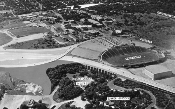
Traveling outbound from downtown, 281 crosses the booming lower Broadway corridor before snaking around the southern edge of the Brackenridge Golf Course. It then continues north shoehorned between the San Antonio Zoo and Alamo Stadium before crossing the Olmos Dam and sailing over the wooded Olmos Basin Park and flood control basin. North of Basse, the landscape becomes increasingly suburban in character, and dense commercial development is achieved near San Antonio International Airport at Loop 410 all the way to 1604 with a short break at the end of an airport runway between Rhapsody and Nakoma. North of 1604, the route passes through the rapidly developing suburban areas of northern Bexar County until the freeway ends at the Comal county line.

|
This section of freeway is occasionally mistakenly referred to as I‑37. While the freeway that is I‑37 and US 281 along the eastern edge of downtown seamlessly crosses I‑35 and continues north, I‑37 actually ends at I‑35 leaving only US 281 to continue north from there. |
Roadway details
| EXITS |
Click here for a list of US 281 North exits. |
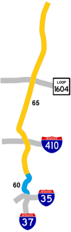
| SPEED LIMITS | |
|
|
|
|
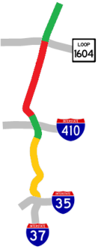
| AVERAGE DAILY TRAFFIC | |||||||
| LOCATION | 2002 | 2012 | 2017 | 2019 | 2021 | 2022 | '12-'22 % CHG |
| N of I‑35 | 130,102 | 129,380 | N/A | ||||
| S of Hildebrand Ave. | 133,592 | 138,119 | N/A | ||||
| N of Hildebrand Ave. | 135,000 | 155,000 | 169,425 | 169,830 | 136,247 | 139,941 | -9.72% |
| N of Basse Rd. | 116,220 | 136,000 | 139,741 | 150,024 | 119,366 | 120,476 | -11.41% |
| S of Sunset Rd. | 121,230 | 146,000 | 151,180 | 150,523 | 119,065 | 121,661 | -16.67% |
| S of Loop 410 | 83,000 | 87,000 | 90,915 | 93,899 | 83,882 | 98,867 | +13.64% |
| N of Loop 410 | 96,000 | 84,000 | 98,735 | 100,180 | 75,069 | 85,176 | +1.40% |
| N of Isom Rd. | 103,000 | 149,000 | 153,221 | 157,461 | N/A | ||
| S of Nakoma Rd. | 158,000 | 189,000 | 190,478 | 194,771 | 116,344 | 176,296 | -6.72% |
| S of Brookhollow Dr. | 124,000 | 146,000 | 163,542 | 169,159 | 173,472 | 155,645 | +6.61% |
| S of Loop 1604 | 111,000 | 114,000 | 102,250 | 106,685 | 101,021 | 158,128 | +38.71% |
| S of Sonterra Blvd. | 87,000 | 110,000 | 97,657 | 87,000 | N/A | ||
| S of Redland Rd. (ML only) | 89,000 | 100,732 | 99,587 | 89,075 | 92,059 | +3.44% | |
(NOTE: In 2021, TxDOT changed the location of several traffic counting stations. New stations will show no history prior to 2021, and discontinued stations will show no history for 2021 or thereafter.)
|
ADVERTISEMENT |
Media gallery
Click here for historical photos of this freeway.
Click here for video of this freeway.
Construction projects
There are currently no major construction projects in this corridor.
Future plans
In 2018, TxDOT announced plans to reconstruct the Jones-Maltsberger and Basse interchanges near the Alamo Quarry Market. A Diverging Diamond Interchange is proposed at Jones-Maltsberger. At Basse, the existing cloverleaf ramps would be removed, and a new southbound exit ramp and northbound entrance ramp added. These projects are currently not projected to start until after 2030.
A project to make several operational improvements in the Loop 410/US 281/San Pedro area will add a collector-distributor road along southbound US 281 between Nakoma and San Pedro and will close the northbound entrance ramp from Jones-Maltsberger north of the airport. More details on that project are here.
With the first HOV lanes now in operation north of Loop 1604, planners are working on long-term plans to extend those HOV lanes — along with other operational improvements — along US 281 to downtown. However, the geometry and right-of-way constraints along much of this route will complicate that planning.
Long-range plans are on the books to upgrade US 281 to a full freeway all the way to FM 306 at the Comal/Blanco county line. The first step toward that eventual plan upgraded 281 from a two-lane road to a four-lane divided highway from the Guadalupe River to FM 306; work on that project was completed in early 2015. Advanced planning is underway for the next expansion that will upgrade US 281 to a full freeway from the Bexar/Comal county line to SH 46. More details on that project are here.
History
Originally known during planning as the "North Expressway", US 281 from I‑35 to San Pedro Ave. is named for Walter McAllister, San Antonio's mayor when the freeway was proposed and one of the main leaders in getting it built.
The section north of Sandau Rd. was originally built as a two-lane road around 1934 as an extension of San Pedro Ave. to be used as the route for US 281 per the Arneson Plan to improve state highways in Bexar County. Prior to then, US 281 and its predecessors SH 66 and SH 108 ran along Nacogdoches, Wetmore, and Bulverde roads.
This corridor has been the subject of major controversy twice in its history. Its initial construction was one of the most controversial freeway projects in US history, requiring a literal act of Congress in order to get built. Plans in the first two decades of this century to extend the freeway north of Loop 1604 with toll lanes were equally contentious.
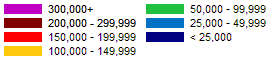
The US 281 corridor has been home to not one, but two freeway intersections that lacked full directional interchanges. Prior to 2008, traffic connecting between Loop 410 and US 281 had to exit and navigate overburdened access roads and/or surface streets to get from one freeway to the other. The lack of an interchange there was a result of the drawn-out battle over the original construction of the McAllister Freeway in the '60s and '70s. A blockbuster project starting in 2004 finally built the multi-level interchange that's there today, with the various flyovers opening in a one-year period between June 2007 and June 2008.
Further north at Loop 1604, a similar situation played-out. Prior to November 2012, all traffic connecting between US 281 and Loop 1604 was required to exit onto the access roads and traverse signalized intersections. The lack of an interchange here was more due to a lack of need until the late '90s, followed by a lack of funding in the early 2000s. However, the first flyovers in today's five-level interchange opened in November 2012 and provided direct connections from US 281 northbound to both directions of Loop 1604. The connectors from Loop 1604 to southbound US 281 opened in late December 2012. The remaining flyovers were constructed as part of the project to extend the US 281 freeway northward, with the connectors from southbound US 281 to both directions of Loop 1604 opening in August 2020, and the last two connectors opening in May 2021.
- 1955: Conceptual planning for the route begins.
- 1959: State begins in-depth route studies.
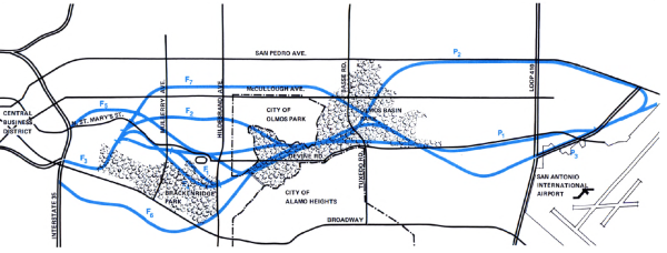
- 1960: No fewer than 12 possible alignments for the freeway between downtown and the airport area were under consideration. These routes were located in a corridor between San Pedro Ave. to the west and Broadway to the east (see map below.) A route that included San Pedro was dismissed because it did not provide direct access to San Antonio International Airport, and routes along Broadway and McCullough would require too much expensive right-of-way to be acquired. So this left mostly "greenfield" routes midway between Broadway and McCullough. The state's preferred route sliced between Trinity University and Alamo Stadium and cut through part of the City of Olmos Park before continuing north over the Olmos Basin. However, Olmos Park vetoed this route, so the Highway Department chose an alternate route that skirted around the eastern edge of the suburb. That route ran between Alamo Stadium, the Sunken Gardens and the San Antonio Zoo, but this forced it to cut through the Incarnate Word campus, which also created controversy. Additionally, the route would take some parkland in both Brackenridge Park and the Olmos Basin.
- January 10, 1961: San Antonio voters approve a bond issue for expressways (63% in favor) and to purchase new parkland to replace the parkland that would be taken for the freeway. (That replacement parkland is now McAllister Park.)
- 1963: Incarnate Word files suit to block the freeway. The suit is subsequently dismissed and a public hearing on the route is held.
- April 1964: The Federal Highway Administration approves the route.
- October 1966: The so-called "Yarborough Rule", named for Texas Senator Ralph Yarborough who sponsored it, was added to federal law and prohibited the taking of parklands for highways unless no other feasible route exists.
- November 1967: Lawsuit filed by the San Antonio Conservation Society asking for reconsideration of the federal approval of the project based on the new federal law, and the federal Secretary of Transportation orders a new analysis of routes for the freeway.
- 1968-1969: Negotiations between the Texas Highway Department and Federal Highway Administration over new routes fail.
- August 1970: After further negotiations, the federal government approves the undisputed northern and southern segments (north of Basse Rd. and south of Mulberry St.) with the stipulation that further study by an independent consultant be done for the middle segment.
- November 1970: The San Antonio Conservation Society requests a federal court to issue an injunction against the construction of the northern and southern segments. The judge rejects the request, and work on the those sections begins a week later.
- June 1971: The independent consultant's San Antonio North Expressway Study is released and recommends an alignment essentially the same as the state's 1960 preferred alignment that had been rejected by Olmos Park.
- June 23, 1971: After a freeway project in Memphis, Tennessee was struck-down by the US Supreme Court for violating the Yarborough Rule, the US 5th Circuit Court uses that precedent to revoke the federal funding for the North Expressway, which essentially renders it dead. Work on the northern and southern sections ceases immediately
- September 1971: The "Citizens Committee for Completion of North Expressway" is formed and, in less than two weeks, collects over 40,000 signatures on a petition calling for the completion of the North Expressway.
- October 1971: The state withdraws its request for federal funding for the project.
- November 1971: Petition drive surpasses 100,000 signatures.
- August 1973: The Federal-Aid Highway Act of 1973 passes that includes a provision sponsored by Texas senators John Tower and Lloyd Bentsen that removes the section of US 281 between I‑35 and Loop 410 from the federal system, thus allowing the city and state to build the freeway on their own without federal funding or oversight.
- December 10, 1973: After yet another legal challenge, the legislation removing all federal involvement in the project was upheld by the US Circuit Court, allowing the city and state to go it alone. Work resumes on the project's stalled northern and southern segments within 24 hours of the ruling. The US Supreme Court subsequently refuses to review the case.
- Mid 1974: A last-ditch lawsuit by the Conservation Society suspends the project for five more months.
- November 1974: Last court challenge is dismissed and work finally begins on the controversial center center section, which at $22.6 million is the largest highway contract in the state's history up to this time.
- February 7, 1978: The freeway between downtown and Sandau Rd. opens to traffic. Originally estimated in 1961 to cost $17 million, the final price tag came in at about $50 million.
- September 11, 1978: Route is certified by the federal government.
- 1980: The existing section of at-grade highway from Sandau Rd. to Bitters Rd. is upgraded to a freeway.
- 1981: The freeway is named by the American Association of State Highway and Transportation Officials as one of the nation's three most beautiful urban freeways.
- 1987: With suburban development continuing to surge northward, a project to upgrade the section from Bitters Rd. to just north of Loop 1604 is started. This project employs several innovative traffic-handling methods during construction which actually result in smoother traffic flow during the construction than before.
- April 1990: Project from Bitters Rd. to Loop 1604 is finished in just 24 months.
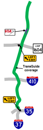
- 1995: TransGuide coverage was added south of St. Mary's St. as part of the original TransGuide project.
- October 1998: TransGuide coverage extended from St. Mary's St. to Basse Rd.
- April 2000: Sonterra Blvd. extended to US 281. Because the city's thoroughfare plan showed a future east-west arterial north of Loop 1604, what's now the Sonterra overpass had been built as part of the 1987-1990 freeway extension project. It was used by construction crews during the project but was inaccessible and unused for nearly a decade until Sonterra Blvd. was finally extended per those earlier plans.
- 2000: The overpass at FM 1863 in Bulverde completed.
- June 2001: Flyover from northbound 281 into the airport opens.
- Early 2004: An additional lane in each direction for most of the route between San Pedro Ave. and Loop 1604 is added by eliminating the inner shoulder and restriping the roadway.
- Late 2004: Work begins on clearing the right-of-way for the tolled expansion of 281 north of 1604 to Stone Oak Pkwy.
- January 2005: A lawsuit by opponents of the toll project stops work. (More detailed history on that project is at the US 281 North expansion project page.)
- Mid-2006: An extra lane in each direction from Hildebrand Ave. to Jones-Maltsberger Rd. near the Quarry is added as part of the 281/410 interchange project by restriping the existing pavement.
- June 18, 2007: The first flyover in the 281/410 interchange opens to traffic.
- June 9, 2008: The final flyovers in the 281/410 interchange open to traffic. The interchange project also adds additional lanes between Loop 410 and Nakoma Dr. and extends TransGuide coverage from Basse to Nakoma Dr. (Also see the History of the US 281/Loop 410 interchange page.)
- October 2010: Work completed to upgrade 281 to a "superstreet" from Encino Rio to Marshall Rd. as a short-term fix to ease congestion while the legal and administrative wrangling for the planned expansion project are settled. (See the superstreets page for more information.)
- November 2012: The first flyovers in the 281/1604 interchange open.
- Late 2015: Toll component removed from expansion plans north of Loop 1604 after Texas voters approve new highway funding.
- July 2017: Work begins to expand US 281 to a non-tolled freeway from Loop 1604 to Stone Oak Pkwy.
- March 2019: Construction to extend the freeway further north from Stone Oak Pkwy. to the county line starts.
- June 2020: Freeway mainlanes from Loop 1604 to Evans Rd. open.
- August 2020: Flyovers from southbound US 281 to Loop 1604 open.
- February 2021: Freeway mainlanes from Evans Rd. to Stone Oak Pkwy./TPC Pkwy. open.
- May 2021: Flyovers from Loop 1604 to northbound US 281 open.
- August 2021: HOV lanes from Evans Rd. to Stone Oak Pkwy./TPC Pkwy. open including ramp to Stone Oak Park & Ride. Ribbon-cutting is held to mark the completion for the first phase of expansion north of Loop 1604.
- May 2023: Freeway mainlanes from Stone Oak Pkwy./TPC Pkwy. to county line open.
|
More historical photos of US 281 North are available here. |