|
||
|
|
||
This page last updated January 29, 2026 |

|
|
|
|
This page covers Interstate 10 south and east of downtown San Antonio from I‑35 to Pfeil Rd. Two miles of I‑10 is concurrent (multiplexed) with I‑35 north of the western end of this segment; see the I‑35 South page for details on that segment. Interstate 10 then continues northwest of downtown; see the I‑10 West page for more info. Length: 11 miles |
|
ADVERTISEMENT |
On this page:


Overview
This unassuming freeway serves San Antonio's East Side neighborhoods as well as industrial areas south of downtown and around Loop 410. Residential areas line most of the route between I‑37 and E Houston St., while commercial and industrial uses front the corridor east of there and also between I‑35 and I‑37.
While the I‑10 frontage east of Foster Rd. is still mostly lightly developed, heavy residential and commercial development exists just north of I‑10 in the FM 78 corridor, and that development is now spreading southward to I‑10 all the way out to FM 1518, and, in the area around Loop 1604, now has even crossed over to the southern side of I‑10. As a result, commuter traffic is growing in this corridor. New industrial development is also occurring within and south of the I‑10 corridor in the Foster Rd. area, which has increased truck traffic in the corridor.
The corridor provides access to the Frost Bank Center and Freeman Coliseum, the San Antonio Missions Trail National Park, and the suburban cities of Kirby and Converse.
Roadway details
| LANES | |
|
|
|
|
| EXITS |
Click here for a list of I‑10 East exits. |
| SPEED LIMITS | |
|
|
|
|
 along entire route
 from I‑35 to Roland Ave.
 from Loop 410 east to Seguin
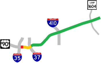
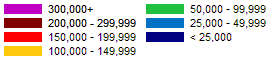
| AVERAGE DAILY TRAFFIC | |||||||
| LOCATION | 2002 | 2012 | 2017 | 2019 | 2021 | 2022 | '12-'22 % CHG |
| E of Loop 1604E | 33,500 | 37,000 | 54,629 | 56,317 | 60,663 | 56,744 | +53.36% |
| W of Loop 1604E> | 33,600 | 46,000 | 61,905 | 65,321 | 75,457 | 70,701 | +53.70% |
| E of Foster Rd. | 41,000 | 55,000 | 71,602 | 75,486 | 80,830 | 75,674 | +37.59% |
| E of Ackerman Rd. | 65,000 | 38,000 | 51,707 | 57,033 | 64,529 | 60,489 | +59.18% |
| E of WW White Rd. | 52,000 | 71,000 | 81,837 | 79,822 | 81,224 | 75,896 | +6.90% |
| W of WW White Rd. | 55,000 | 71,000 | 79,742 | 78,059 | 80,225 | 74,960 | +5.58% |
| E of Martin Luther King Jr. Dr. | 56,000 | 71,000 | 86,323 | 77,872 | 83,311 | 77,787 | +9.56% |
| W of Gevers St. | 72,000 | 86,000 | 91,302 | 88,996 | 100,519 | 93,944 | +9.24% |
| E of Probandt St. | 114,000 | 117,000 | 152,676 | 149,338 | 147,822 | 138,021 | +17.97% |
| W of Probandt St. | 116,000 | 120,000 | 154,537 | 149,616 | 146,320 | 151,312 | +26.09% |
|
ADVERTISEMENT |
Media gallery
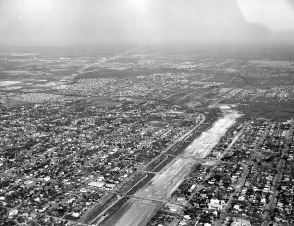
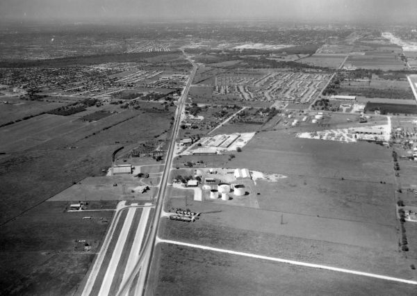
Click here for historical photos of this freeway.
Click here for video of this freeway.
Construction projects
- WW White Rd. to Ackerman Rd.: Replace cloverleaf interchange at Loop 410 with five-level "stack" interchange. Click here for details on this project.
- Loop 1604 to Pfeil Rd.: Expand to six-lane freeway. Click here for details on this project.
Click here to view information for all projects in this corridor.
Future plans
TxDOT has plans to upgrade both the Loop 410 and Loop 1604 interchanges. The first phase of a fully-directional, five-level "stack" interchange at Loop 410 is currently under construction. A future phase(s) will construct the remainder of the interchange.
A five-level "stack" interchange was proposed at Loop 1604 as part of an earlier Loop 1604 project, but it is now expected to be done as a standalone project.
A project to widen I‑10 through Seguin is started construction in early 2024. TxDOT plans to eventually widen all of I‑10 between San Antonio and Houston to six lanes.
History
US 90 and its predecessor SH 3 heading east to Seguin originally followed today's FM 78. A new alignment for US 90 that followed today's I‑10 east of Commerce St. was built in 1932 as part of the Arneson Plan to improve state highways in Bexar County. Most of that original alignment is where the westbound frontage road is today.
This freeway was originally called the "East Expressway" and was also known for a short time as the "Highland Park Expressway." It was renamed in 1994 for José Lopez, a Medal of Honor recipient. The designation as I‑10 was authorized on October 1, 1959.
The routing of the freeway between Loop 410 and downtown was subject to several revisions and some controversy before today's alignment was finalized in 1959. Planning for this route was done in conjunction with the planning for I‑37.
- 1945: The earliest expressway plans would have routed this freeway from the WW White Rd. area northwest to join I‑35 near Frost Bank Center Dr.
- 1952: An new proposal for this freeway would have used today's I‑10 and Commerce St. from Loop 410 to just west of Salado Creek. From there, the route would have followed the Aransas Ave. corridor to near New Braunfels Ave. where it would have turned west and followed the Indiana St. corridor. After crossing today's I‑37, it would have turned northwest and crossed Presa St. and St. Mary's St. at Sadie St. Continuing northwest, it would have crossed Alamo St., the King William District, and the San Antonio River between Sheridan St. and Beauregard St. It then would have continued along Arsenal St. and El Paso St. to an interchange with I‑35.
- 1956: The proposed alignment was shifted further south and included today's route between I‑35 and I‑37. From there, it would have continued east along the Bailey Ave. corridor to Clark Ave. before turning northeast to meet Houston St. just east of Commerce St. This route generated significant controversy.
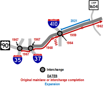
- 1959: The alignment for the route inside Loop 410 was finally settled. Meanwhile, the freeway segment from just inside Loop 410 to just west of FM 1516 was completed.
- 1962: The freeway from FM 1516 to the county line was completed.
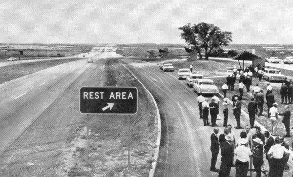
- 1963: The first Interstate rest area in Texas opens on I‑10 just west of FM 1518. (It was closed and removed sometime around 2006.)
- 1964: The section from Commerce St. to Loop 410 and the Loop 410 interchange were completed.
- 1967: The segment between I‑35 and I‑37 opened.
- 1968: The section from I‑37 to Commerce St. opened.
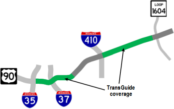
- 1995: TransGuide coverage was added from I‑35 to Roland Ave. as part of the original TransGuide project.
- 2009: Various operational improvements were made to the section between Loop 410 and Foster Rd.
- 2010: Operational improvements were made at the Loop 410 interchange.
- 2011: The Texas Transportation Commission approved extending the SH 130 designation along I‑10 from the terminus of the SH 130 toll road east of Seguin to Loop 410, then south along Loop 410 to I‑35 South. Signage was installed in 2013.
- 2021: The section from Loop 410 to Loop 1604 was widened to six lanes.
- 2023: The first flyover in the upgraded Loop 410 interchange — from northbound Loop 410 to eastbound I‑10 — was opened.
|
More historical photos of I-10 are available here. |