|
||
|
|
||
This page last updated February 29, 2024 |

|
|
|
|
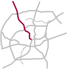
This page covers Interstate 10 northwest of downtown San Antonio from I‑35 to Ralph Fair Rd. Two miles of I‑10 is concurrent (multiplexed) with I‑35 south of this segment; see the I‑35 South page for details. Interstate 10 continues east of downtown; see the I‑10 East page for more info. Length: 16 miles |
|
ADVERTISEMENT |
On this page:


Overview
This segment of I‑10 serves the northwest corridor, one of the fastest growing areas of the city. A tremendous amount of the region's suburban office space is located in this corridor as are the headquarters for several large companies. The corridor also serves the bustling and continually-growing South Texas Medical Center district; Wonderland of the Americas mall (formerly known as Crossroads mall); the University of Texas at San Antonio's (UTSA) main and downtown campuses; Six Flags Fiesta Texas; Joint Base San Antonio Camp Bullis and Camp Stanley; and The Rim, La Cantera, Landmark, Colonnade, Huebner Oaks, and Fiesta Trails retail centers and mixed-use developments.
One suburban city, Balcones Heights, also lies within the corridor as does the unincorporated Leon Springs area. I‑10 continues northward to the booming outlying areas of Fair Oaks Ranch, Boerne, and Kendall County.
Inside Loop 410, the route is lined with light industrial and residential areas. Heavy commercial development dominates the landscape between Loop 410 and La Cantera Blvd., with moderate and growing commercial and residential development north of there all the way to Boerne.

|
While it is signed as east/west, this segment actually runs mostly north/south. To avoid confusion, many locals give directions as "inbound" or "outbound" (from downtown) instead; I use that convention here. |
Roadway details
| EXITS |
Click here for a list of I‑10 West exits. |
| SPEED LIMITS | |
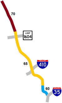
|
|
|
|
| SPECIAL FEATURES AND NOTES | |
|
|
|
|
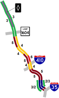
 concurrent (multiplexed) along entire route
| AVERAGE DAILY TRAFFIC | |||||||
| LOCATION | 2002 | 2012 | 2017 | 2019 | 2021 | 2022 | '12-'22 % CHG |
| W of I‑35 | 196,369 | N/A | |||||
| W of Frio St. | 160,000 | 195,000 | 186,907 | 187,306 | 178,837 | 187,233 | -3.98% |
| S of Hildebrand Ave. | 179,420 | 193,828 | N/A | ||||
| S of Crossroads Blvd. | 154,000 | 212,000 | 205,971 | 206,072 | 219,228 | 216,551 | +2.15% |
| N of Callaghan Rd. | 173,000 | 223,000 | 241,428 | 241,130 | 237,094 | 253,181 | +13.53% |
| N of Huebner Rd. | 133,000 | 211,000 | 184,794 | 182,384 | 183,673 | 205,973 | -2.38% |
| N of DeZavala Rd. | 159,000 | 226,000 | 204,596 | 199,029 | 202,353 | 208,179 | -7.89% |
| N of UTSA Blvd. | 111,000 | 177,000 | 158,415 | 156,092 | 183,419 | 183,748 | +3.81% |
| N of Loop 1604W | 71,000 | 121,000 | 117,410 | 121,393 | 150,152 | 154,479 | +27.67% |
| N of Dominion Dr. | 58,000 | 83,000 | 93,140 | 98,299 | 131,740 | 136,247 | +64.15% |
| N of FM 3351 | 45,000 | 56,000 | 66,205 | 80,745 | 81,446 | 84,329 | +50.59% |
(NOTE: In 2021, TxDOT changed the location of several traffic counting stations. New stations will show no history prior to 2021, and discontinued stations will show no history for 2021 and thereafter.)
|
ADVERTISEMENT |
Media gallery
Click here for historical photos of this freeway.
Click here for video of this freeway.
Construction projects
- DeZavala Rd. to Camp Bullis Rd.: Replace cloverleaf interchange with five-level "stack" interchange. Click here for details on this project.
Click here to view information for all projects in this corridor.
Future plans
TxDOT plans to add one general purpose lane and one HOV lane in each direction from Ralph Fair Rd. to Boerne. There is currently no funding or timeline for that expansion.
History
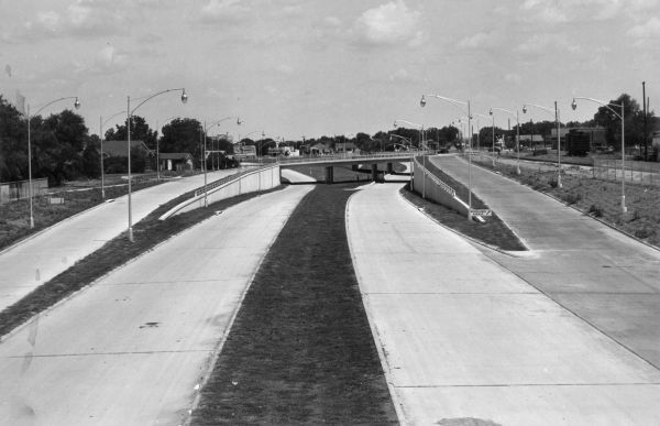
The section from Culebra Ave. to Fredericksburg Rd. at Woodlawn Ave. was San Antonio's first expressway.
Most of the route from just north of Huebner Rd. to Leon Springs was part of the original route of US 87 and its predecessors US 290, US 385, SH 9, and SH 27. The short section of Old Fredericksburg Rd. at Loop 1604 was bypassed by the current route in 1934 as part of the Arneson Plan to improve state highways in Bexar County. The section of I‑10 today north of Leon Springs was also built in 1934 as part of the Arneson Plan; prior to that, the state routes followed Boerne Stage Rd.
The first freeway sections to be built were simply called "US 87 Expressway". It was briefly called the "North Expressway" before being named the "Northwest Expressway" when planning began for the US 281 "North Expressway". The designation as I‑10 was authorized on October 1, 1959. The route was renamed as "McDermott Freeway" ca. 1995 for Robert F. McDermott, the former CEO of the USAA financial services corporation whose headquarters are located adjacent to the freeway south of Huebner Rd.
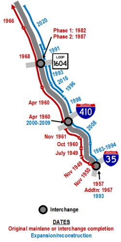
- Late 1930s: The section from I-35 to Woodlawn Ave. was included as part of the original three-legged expressway plan for San Antonio designed to provide bypass routes around downtown for through traffic on the various US and state highways. The United States' entrance into World War II delayed these plans until after the war.
- July 8, 1949: The section from Culebra Ave. to Fredericksburg Rd. at Woodlawn Ave. opened without fanfare. This was the first expressway in San Antonio and appears to be the second in Texas, coming less than a year after the Gulf Freeway opened in Houston and a month before the opening of Central Expressway in Dallas.
- November 28, 1949: The section from Frio St. to Culebra Ave. opened with the official ribbon-cutting for the entire Frio St. to Woodlawn Ave. section.
- November 1950: The segment from Martin St. to Frio St. was completed.
- June 1955: Alignment finalized for the routing of the section from Woodlawn Ave. to De Zavala Rd. A previous proposal in 1953 had I‑10 further east crossing Loop 410 at Vance Jackson Rd., and a plan from around 1951 showed it paralleling Fredericksburg Rd. roughly ⅔ of a mile to the east.
- 1957: "Downtown Y" interchange completed.
- April 1960: The section from Loop 410 to Fredericksburg Rd. north of Huebner Rd. was completed including the interchange at Loop 410.
- October 1960: The segment from Woodlawn Ave. to Fresno Dr. opened.
- November 1961: The section from Fresno Dr. to Loop 410 was completed.
- 1966: The section from Dominion Dr. to Boerne opened.
- 1967: The ramps connecting I‑35 North to and from I‑10 West in the "Downtown Y" interchange were completed. Prior to this, there were only direct connections between I‑35 South and I‑10 West. Traffic headed to and from I‑35 North had to exit and use the access roads
- 1968: The existing segment of US 81 from Fredericksburg Rd. near Huebner to Dominion Dr. was upgraded to a freeway.
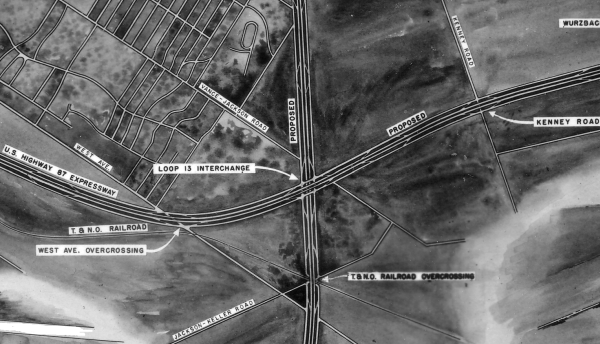
- 1982: First phase of Loop 1604 interchange completed.
- 1983-1994: Reconstruction and double-decking from I‑35 to Hildebrand Ave.
- 1987: Loop 1604 interchange completed.
- 1991: The segment from Loop 1604 to Camp Bullis Rd. widened from four to six lanes.
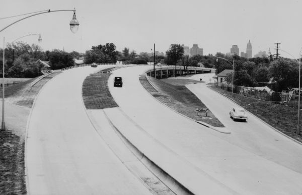
- 1992: The music group REM filmed the video for their song "Everybody Hurts" on the lower level at Woodlawn Ave. Producers had originally wanted to use US 281 North at Loop 1604, but decided it looked too wide in camera shots.
- 1993: The section from Fredericksburg Rd. (near Huebner) to Loop 1604 widened from four to six lanes.
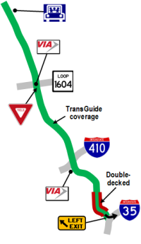
- 1995: TransGuide coverage added between I‑35 and Hildebrand Ave. as part of the original TransGuide project.
- 1996: The segment from Wurzbach Rd. north to Fredericksburg Rd. was expanded from four to eight lanes.
- 1998: The section from Callaghan Rd. to Wurzbach Rd. was widened from four to eight and 10 lanes.
- 1999: TransGuide coverage extended from Hildebrand Ave. to Camp Bullis Rd.
- 2000-2009: Loop 410 interchange reconstructed.
- 2008: The section from Fulton Ave. to Crossroads Blvd. was widened from six to 10 lanes.
- 2009: Dominion Dr. overpass completed and access roads between Camp Bullis Rd. and Dominion Dr. converted to one-way.
- 2011: Reconstruction from Camp Bullis Rd. to Dominion Dr. to raise and lengthen the Camp Bullis overpass and improve drainage was completed.
- 2016: The section from Ramsgate Dr. to Loop 1604 was widened from six to eight lanes.
- 2017: Conversion of access roads to one-way and other improvements from Dominion Dr. to Leon Springs completed.
- 2020: The section from La Cantera Blvd. to Ralph Fair Rd. widened to six lanes plus two HOV lanes.
|
More historical photos of I-10 are available here. |