|
||
|
|
||
This page last updated June 2, 2026 |

|
|
|
|
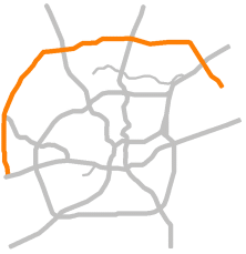
This page covers the freeway segment of Loop 1604 across North and West San Antonio from FM 78 in Converse to US 90 West. The remainder of the 94 mile loop — which is the longest loop in Texas — is non-freeway, most of which is a two-lane rural road. Length (freeway section): 39 miles |
|
ADVERTISEMENT |
On this page:


Overview
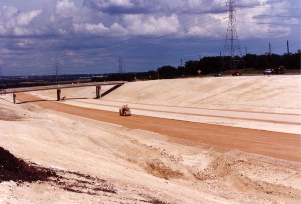
When the first segments were built in the 1960s, it would have been hard to fathom that Loop 1604 North would become the busy beltline that it is today. While the southern half remains mostly in its original configuration as a two-lane rural state highway (for now), the northern arc has been expanded to a four-lane freeway, with work now underway to expand it to 10 lanes.
Loop 1604 forms the outer of San Antonio's two beltways. The freeway portion serves Joint Base San Antonio Randolph and Camp Bullis, the Forum and Live Oak Town Center shopping centers, Rolling Oaks Mall, the Stone Oak area, the University of Texas at San Antonio's (UTSA) main campus, Six Flags Fiesta Texas, the Shops at La Cantera and the La Cantera development, The Rim development, the corporate headquarters campuses for Valero Energy and NuStar, the Alamo Ranch area, Sea World and the Westover Hills area, and the suburban cities of Converse, Universal City, Live Oak, Selma, Hollywood Park, Shavano Park, and Helotes.
The corridor runs through increasingly dense suburban residential areas interspersed with moderate to heavy commercial development, especially at the main nodes near I‑35, Bulverde Rd., US 281, Blanco Rd., I‑10, Bandera Rd., Culebra Rd./SH 151, and Potranco Rd. The area outside 1604 from Bandera Rd. to US 90 is expected to add roughly 200,000 people between 2020 and 2030.
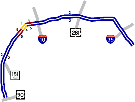
A five-level "stack" interchange exists at US 281 with cloverleaf interchanges at I‑10 and I‑35. There is a single flyover connector from southbound Loop 1604 to eastbound SH 151 as well as from southbound Loop 1604 to US 90 eastbound. Work to replace the cloverleaf at I‑10 is underway, as is a project to add a new direct connector from SH 151 to northbound Loop 1604.

|
Loop 1604 is sometimes mistakenly referred to as FM 1604. However, FM 1604 is in North Texas. (See the History section below for more info.) |
Roadway details
| EXITS |
Click here for a list of Loop 1604 exits. |
| SPEED LIMITS | |
|
|
|
|
| SPECIAL FEATURES AND NOTES | |
|
|
|
|
| AVERAGE DAILY TRAFFIC | |||||||
| LOCATION | 2002 | 2012 | 2017 | 2019 | 2021 | 2022 | '12-'22 % CHG |
| E of FM 78 | 23,000 | 31,000 | 41,129 | 41,903 | 40,724 | 43,030 | +38.81% |
| W of FM 78 | 43,000 | 55,000 | 67,174 | 67,555 | 61,928 | 61,606 | +12.01% |
| S of Pat Booker Rd. | 59,000 | 64,000 | 67,020 | 62,190 | 79,271 | 78,128 | +22.08% |
| N of Pat Booker Rd. | 59,000 | 72,000 | 98,853 | 102,231 | 84,141 | 82,167 | +14.12% |
| W of I‑35N | 67,000 | 91,000 | 123,230 | 126,780 | 111,655 | 110,652 | +21.60% |
| N of Lookout Rd. | 67,000 | 91,000 | 116,417 | 123,206 | 103,520 | 101,808 | +11.88% |
| N of Nacogdoches Rd. | 58,000 | 88,000 | 111,072 | 113,497 | 92,035 | 91,556 | +4.04% |
| W of O'Connor Rd. | 69,000 | 88,000 | 112,228 | 118,185 | 111,204 | 109,716 | +24.68% |
| E of Gold Canyon Rd. | 86,000 | 105,000 | 121,579 | 126,300 | 126,961 | 115,802 | +10.29% |
| W of US 281N | 104,000 | 120,000 | 125,989 | 131,146 | 100,343 | 125,841 | +4.87% |
| E of Bitters Rd. | 85,000 | 113,000 | 161,000 | 164,218 | 154,706 | 116,008 | +2.66% |
| W of NW Military Hwy. | 127,585 | 125,360 | N/A | ||||
| W of Vance Jackson Rd. | 85,000 | 128,000 | 142,249 | 146,905 | 126,819 | 119,379 | -6.74% |
| W of I‑10W | 71,000 | 113,000 | 131,409 | 134,730 | 116,488 | 112,733 | -0.24% |
| N of Hausmann Rd. | 61,000 | 100,000 | 114,499 | 116,399 | 101,084 | 104,741 | +4.74% |
| N of Bandera Rd. | 59,000 | 100,000 | 122,687 | 136,161 | 108,092 | 110,080 | +10.08% |
| S of Bandera Rd. | 41,000 | 83,000 | 89,976 | 102,305 | 115,987 | 120,361 | +45.01% |
| S of Braun Rd. | 108,514 | 112,745 | N/A | ||||
| N of Culebra Rd. | 24,000 | 74,000 | 97,685 | 119,406 | 128,082 | 130,444 | +76.28% |
| S of Culebra Rd. | 29,000 | 85,000 | 86,833 | 115,180 | 131,343 | 129,333 | +52.16% |
| S of SH 151 | 75,535 | 72,309 | N/A | ||||
| N of Potranco Rd. | 19,300 | 34,000 | 33,664 | 31,528 | 45,023 | 42,774 | +25.81% |
| S of Potranco Rd. | 67,160 | 63,280 | N/A | ||||
| N of US 90W | 16,300 | 26,000 | 27,402 | 41,185 | 45,285 | 45,557 | +75.22% |
(NOTE: In 2021, TxDOT changed the location of several traffic counting stations. New stations will show no history prior to 2021.)
|
ADVERTISEMENT |
Media gallery
Click here for historical photos of this freeway.
Click here for video of this freeway.
Construction projects
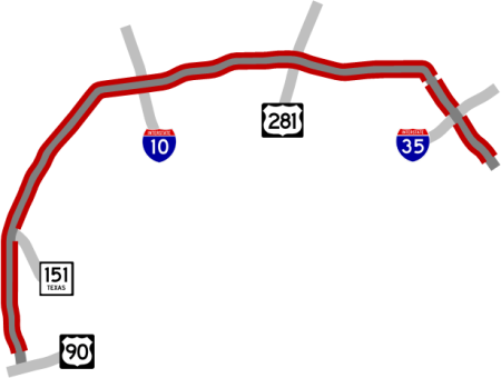
- Redland Rd. to Bandera Rd.: This project is expanding the freeway to 10 lanes including two HOV lanes and rebuilding the I‑10 interchange. Click here for more information on this project.
Click here to view information for all projects in this corridor.
Future plans
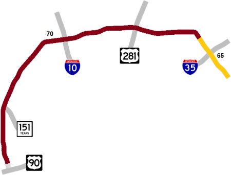
In 2018, plans were announced to upgrade the section from I‑10 East to FM 78 to a full freeway, which is now estimated to start after 2030. Details of those plans are here.
Plans had been in the works since around 2005 to expand Loop 1604 from I‑35 North to Bandera Rd. by adding tolled managed lanes in the median between the existing lanes. The environmental study for that project, however, was delayed several times over the years due to changes in its scope caused by the unexpected availability of funding for non-tolled expansions in the western corridor and, later, due to funding shortages for the study itself.
A study is currently underway on possible future improvements and expansions of the western segment from Bandera Rd. south to US 90.
TxDOT plans to eventually expand all of Loop 1604 south of US 90 to a four-lane divided highway. The first two projects are now complete. Two more projects are expected to start in the next decade. Click here for more information on these projects.
History
Loop 1604 was authorized by Transportation Commission Minute Order 72928 (June 30, 1977). It's named "Anderson Loop" for former Bexar County Judge Charles W. Anderson who advocated for an outer loop during the mid 1950s. Anderson served as Bexar County Judge from 1939 until his death in 1964.
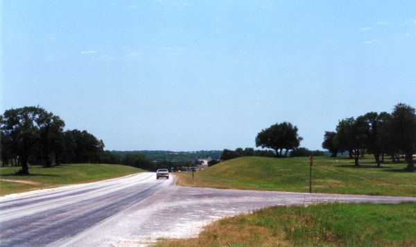
The first plans for an outer loop around San Antonio emerged in 1956, and ground was broken on the first segment — from US 281 to I‑10 on the North Side — on August 4th, 1960. Most of the northern half was built as new "greenfield" route, while most of the southern half usurped the existing routes of FM 2173 and FM 1518. As those southern sections were incorporated into the loop, improvements were made such as straightening some of the more crooked sections and building bypasses at Somerset, Elmendorf, and Lone Oak. The initial plan for the loop was to build a "starter" two-lane road, then come back later and expand to a four-lane divided highway, and the state acquired plenty of right-of-way for future expansions.
Loop 1604 was originally planned to be numbered Loop 26. In 1958, it was reportedly planned to be numbered Loop 334. However, as the route was initially built to Farm-to-Market road standards, the first sections were instead numbered FM 1604.
When the loop was nearing completion in 1977, state officials were ready to change the designation from FM to Loop. Because loops are typically assigned a one to three digit number, this should have resulted in a new number being assigned. But the route number 1604 had already become so ingrained with area residents that state officials decided to simply switch the route prefix from FM to Loop, keeping the route number as 1604. As a result, until 2020, Loop 1604 was the only four-digit loop and one of just four four-digit state highways in Texas that is not a Farm-to-Market road. (In 2020, Loop 1853 was approved for a bypass around Madisonville. Although it is a new-location route, the route number was requested by Madison County to commemorate the year the county was established.) The FM 1604 designation has since been recycled and is in use on a short route in Irene, Texas, east of Hillsboro. Regardless, many locals still continue to (incorrectly) refer to Loop 1604 as FM 1604.
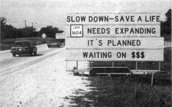
In the late '70s and most of the '80s, the northern and western sections of Loop 1604, which were still mostly two-lane farm road, became known as "The Death Loop" due to a high number of fatal accidents caused by the high volume of traffic — especially truck traffic, intersections, limited sightlines due to the hilly terrain, and dark stretches at night.
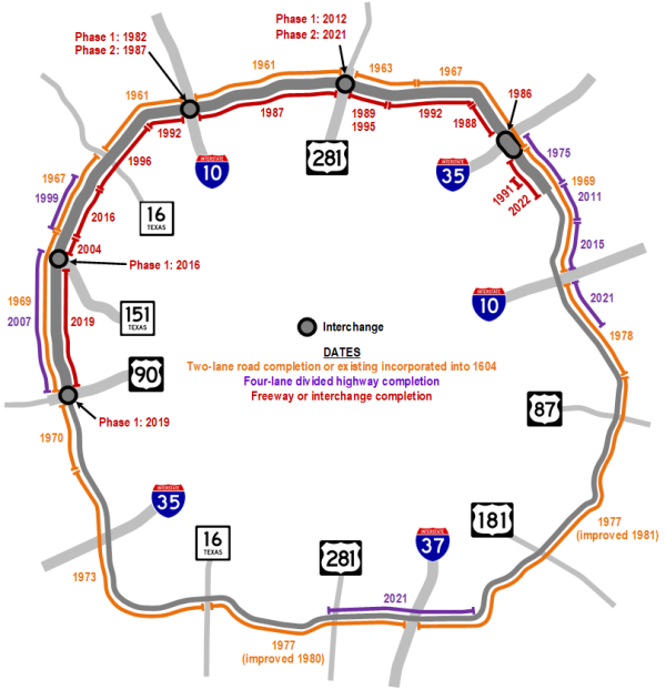
The opening dates below up to 1981 are for the original two-lane rural road.
- 1956: The general route that is Loop 1604 today appears in the master expressway plan for Bexar County.
- 1961: Section between US 281 North and I‑10 West is completed as FM 1604, followed by the segment from I‑10 West to Bandera Rd.
- 1963: Segment from Bulverde Rd. to US 281 is completed.
- 1967: Sections from Bandera Rd. to Culebra Rd. and from Pat Booker Rd. to Bulverde Rd. are completed.
- 1969: Segment from I‑10 East to Pat Booker Rd. is completed as well as the section from Culebra Rd. to US 90 West.
- 1970: Section from US 90 West to Macdona Lacoste Rd. is completed.
- 1972: FM 2173 from Macdona Lacoste Rd. to Somerset and FM 1518 from Somerset to SH 16 South is improved and renumbered as FM 1604.
- 1975: Section from FM 78 to I‑35 North is expanded to a four-lane divided highway.
- 1977: FM 1518 from SH 16 South to La Vernia Rd. is incorporated into 1604, and the route designation is changed from FM 1604 to Loop 1604.
- 1978: Segment from La Vernia Rd. to I‑10 East is opened, officially completing the loop.
- 1980: Section of FM 1518 from SH 16 South to I‑37 is straightened and improved.
- 1981: Section of FM 1518 from I‑37 to La Vernia Rd. is straightened and improved.
- 1982: The first half of the cloverleaf interchange at I‑10 West is completed.
- 1986: The current interchange at I‑35 North is completed.
- 1987: The remainder of the cloverleaf at I‑10 West is completed, and the section between US 281 North and I‑10 West is upgraded to a four-lane freeway except for the overpass at Lockhill-Selma Rd., which is completed in 1991.
- 1988: Segment from I‑35 North to Green Mountain Rd. is upgraded to a four-lane freeway.
- 1989: Section from Redland Rd. to US 281 North is upgraded to a four-lane freeway except for the mainlanes and overpass at Gold Canyon Rd.; those are completed in 1995.
- 1991: Overpass and interchange at Kitty Hawk Rd. is built, and the segment between Kitty Hawk Rd. and Pat Booker Rd. is improved.
- 1992: Sections from Redland Rd. to Green Mountain Rd. and from Babcock Rd. to I‑10 West are upgraded to a four-lane freeway.
- 1996: Segment from Babcock Rd. to Braun Rd. is upgraded to a four-lane freeway.
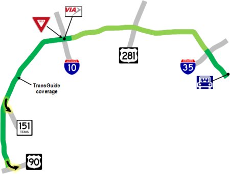
- 1999: Section from Braun Rd. to near Culebra Rd. is expanded to a four-lane divided highway, and TransGuide coverage is added to the section between Tradesman Dr. and Babcock Rd.
- 2002: Access roads between Bitters Rd. and NW Military Hwy. are completed.
- 2003: TransGuide coverage is extended from Babcock Rd. to Bandera Rd.
- 2004: Overpass and interchange at Culebra Rd. is completed.
- 2007: Section from SH 151 to US 90 West is expanded to a four-lane divided highway. TxDOT and the Alamo Regional Mobility Authority announced a $1.8 billion mega-project to upgrade and expand Loop 1604 across northern San Antonio from I‑10 East around to Military Dr. West. This project would have added tolled freeway lanes where there were no freeway lanes (i.e. south of Braun Rd. and south of FM 78). Between FM 78 and Braun Rd., the project would have added new tolled managed lanes in the median between the existing non-tolled freeway lanes, which would have remained non-tolled. Additionally, it would have built new interchanges at SH 151, I‑10 West, US 281 North, I‑35 North, and I‑10 East. That project was eventually broken-up into smaller, non-tolled projects.
- 2009: Congress approves a national economic "stimulus" plan that pours additional federal money into road construction projects. The Metropolitan Planning Organization (MPO) approves allocating San Antonio's share of transportation stimulus funding to be used as matching funds to leverage state funding for first half of a 281/1604 interchange.
- 2011: The segment from Lower Seguin Rd. to FM 78 is expanded to a four-lane divided highway. The section from Shaenfield Rd. to Guilbeau Rd. is upgraded to a "superstreet" as an interim measure to ease congestion while funding for an upgrade to a freeway is pending.
- 2012: Local officials identify funding to construct new non-tolled freeway lanes from Bandera Rd. south to SH 151. After a funding swap to remove federal funding from the project, it is removed from the on-going federal environmental study for the entire 1604 corridor, which allows the state to begin construction after a state environmental approval.
- Late 2012: Flyovers in Phase 1 of the US 281/Loop 1604 interchange open.
- 2013: Overpass at Vance Jackson Rd. is completed.
- 2014: TxDOT and ARMA officials announce funding had been secured to extend the non-toll freeway south from SH 151 to US 90 and build an elevated direct connector from southbound Loop 1604 to eastbound US 90.
- 2015: Section from I‑10 East to Lower Seguin Rd. is expanded to a four-lane divided highway.
- 2016: Freeway lanes from Braun Rd. to SH 151, the flyover from southbound Loop 1604 to SH 151, and the overpass from SH 151 to Alamo Ranch Parkway all open.
- 2018: MPO votes to remove toll lanes from planned expansion from I‑35 North to Bandera Rd. after additional state funding for the project is forecast.
- 2019: Section from SH 151 to US 90 West is upgraded to a four-lane freeway, and the flyover from southbound Loop 1604 to eastbound US 90 opens.
- 2020: Flyovers from southbound US 281 to Loop 1604 open.
- 2021: Flyovers from Loop 1604 to northbound US 281 open. The segments from Martinez Creek to I‑10 East and from US 281 South to FM 1303 are expanded to a four-lane divided highway.
- 2022: The section from FM 78 to Pat Booker Rd. is upgraded to a full freeway.
- 2026: The section from Bandera Rd. to I‑10 West is expanded.
|
More historical photos of Loop 1604 are available here. |